El Granada, California
| El Granada | |
|---|---|
| census-designated place | |
|
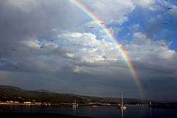
El Granada panoramio | |
 Location in San Mateo County and the state of California | |
 El Granada Location in the United States | |
| Coordinates: 37°30′14″N 122°28′24″W / 37.50389°N 122.47333°WCoordinates: 37°30′14″N 122°28′24″W / 37.50389°N 122.47333°W | |
| Country |
|
| State |
|
| County | San Mateo |
| Area[1] | |
| • Total | 4.822 sq mi (12.489 km2) |
| • Land | 4.822 sq mi (12.489 km2) |
| • Water | 0 sq mi (0 km2) 0% |
| Elevation | 39 ft (12 m) |
| Population (2010) | |
| • Total | 5,467 |
| • Density | 1,100/sq mi (440/km2) |
| Time zone | PST (UTC-8) |
| • Summer (DST) | PDT (UTC-7) |
| ZIP code | 94018 |
| Area code(s) | 650 |
| FIPS code | 06-21936 |
| GNIS feature ID | 1659720 |
El Granada is a census-designated place (CDP) in the coastal area of northern San Mateo County, California, United States. The population was 5,467 at the 2010 census.
Geography
El Granada is located at 37°30′14″N 122°28′24″W / 37.50389°N 122.47333°W (37.503766, -122.473230),[2] on the less densely populated Pacific coast side of San Mateo County, approximately 25 miles (40 km) south of San Francisco and 45 miles (72 km) north of Santa Cruz, California. Neighboring towns include Montara and Moss Beach to the north and Half Moon Bay to the south.
According to the United States Census Bureau, the CDP has a total area of 4.8 square miles (12 km2), all of it land.
Demographics
2010
The 2010 United States Census[3] reported that El Granada had a population of 5,467. The population density was 1,133.7 people per square mile (437.7/km²). The racial makeup of El Granada was 4,608 (84.3%) White, 45 (0.8%) African American, 38 (0.7%) Native American, 190 (3.5%) Asian, 5 (0.1%) Pacific Islander, 336 (6.1%) from other races, and 245 (4.5%) from two or more races. Hispanic or Latino of any race were 813 persons (14.9%).
The Census reported that 5,453 people (99.7% of the population) lived in households, 14 (0.3%) lived in non-institutionalized group quarters, and 0 (0%) were institutionalized.
There were 2,098 households, out of which 660 (31.5%) had children under the age of 18 living in them, 1,245 (59.3%) were opposite-sex married couples living together, 163 (7.8%) had a female householder with no husband present, 69 (3.3%) had a male householder with no wife present. There were 132 (6.3%) unmarried opposite-sex partnerships, and 33 (1.6%) same-sex married couples or partnerships. 420 households (20.0%) were made up of individuals and 124 (5.9%) had someone living alone who was 65 years of age or older. The average household size was 2.60. There were 1,477 families (70.4% of all households); the average family size was 3.00.
The population was spread out with 1,199 people (21.9%) under the age of 18, 314 people (5.7%) aged 18 to 24, 1,269 people (23.2%) aged 25 to 44, 2,106 people (38.5%) aged 45 to 64, and 579 people (10.6%) who were 65 years of age or older. The median age was 44.5 years. For every 100 females there were 96.4 males. For every 100 females age 18 and over, there were 95.3 males.
There were 2,198 housing units at an average density of 455.8 per square mile (176.0/km²), of which 1,592 (75.9%) were owner-occupied, and 506 (24.1%) were occupied by renters. The homeowner vacancy rate was 0.7%; the rental vacancy rate was 4.0%. 4,205 people (76.9% of the population) lived in owner-occupied housing units and 1,248 people (22.8%) lived in rental housing units.
2000
As of the census[4] of 2000, there were 5,724 people, 2,028 households, and 1,512 families residing in the CDP. The population density was 1,062.7 people per square mile (410.0/km²). There were 2,097 housing units at an average density of 389.3 per square mile (150.2/km²). The racial makeup of the CDP in 2010 was 77.0% non-Hispanic White, 0.6% non-Hispanic African American, 0.3% Native American, 3.4% Asian, 0.1% Pacific Islander, 0.3% from other races, and 3.3% from two or more races. Hispanic or Latino of any race were 14.9% of the population.
There were 2,028 households out of which 39.3% had children under the age of 18 living with them, 61.8% were married couples living together, 8.2% had a female householder with no husband present, and 25.4% were non-families. 17.8% of all households were made up of individuals and 2.9% had someone living alone who was 65 years of age or older. The average household size was 2.82 and the average family size was 3.18.
In the CDP the population was spread out with 26.8% under the age of 18, 6.0% from 18 to 24, 31.7% from 25 to 44, 29.1% from 45 to 64, and 6.4% who were 65 years of age or older. The median age was 38 years. For every 100 females there were 102.1 males. For every 100 females age 18 and over, there were 99.8 males.
The median income for a household in the CDP was $91,979, and the median income for a family was $96,095. Males had a median income of $54,122 versus $48,065 for females. The per capita income for the CDP was $38,832. About 1.1% of families and 3.0% of the population were below the poverty line, including 3.0% of those under age 18 and 7.3% of those age 65 or over.
History
El Granada's unusual concentric-circular street layout was designed by the influential architect and city planner Daniel Burnham. Burnham's other works included overseeing the design for the 1893 Columbian Exposition in Chicago and designing the 1902 Flatiron Building in New York City. Burnham's plan was commissioned by the Ocean Shore Railroad, which developed El Granada as a seaside resort for visitors from San Francisco.[5] He developed city plans for San Francisco (1905), Chicago (1909), Manila and the Mall in Washington D.C. His company designed many noteworthy buildings in Chicago, San Francisco, Pittsburgh and other cities in the US. He is buried on an island with his family under granite boulders in Graceland Cemetery, Chicago.
Government
In the California State Legislature, El Granada is in the 13th Senate District, represented by Democrat Jerry Hill, and in the 24th Assembly District, represented by Democrat Marc Berman.[6]
Federally, El Granada is in California's 14th congressional district, represented by Democrat Jackie Speier.[7]
References
- ↑ U.S. Census
- ↑ "US Gazetteer files: 2010, 2000, and 1990". United States Census Bureau. 2011-02-12. Retrieved 2011-04-23.
- ↑ "2010 Census Interactive Population Search: CA - El Granada CDP". U.S. Census Bureau. Retrieved July 12, 2014.
- ↑ "American FactFinder". United States Census Bureau. Retrieved 2008-01-31.
- ↑ VanderWerf, Barbara (1992), Granada, A Synonym for Paradise: The Ocean Shore Railroad Years. El Granada: Gum Tree Lane Press. ISBN 0-9632922-0-X
- ↑ "Statewide Database". UC Regents. Retrieved December 29, 2014.
- ↑ "California's 14th Congressional District - Representatives & District Map". Civic Impulse, LLC. Retrieved March 12, 2013.
External links
Municipalities and communities of San Mateo County, California, United States | ||
|---|---|---|
| Cities and towns | 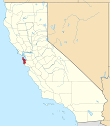 | |
| CDPs | ||
| Unincorporated communities | ||
| Ghost towns | ||
| Bodies of water |
|  |
|---|---|---|
| Counties | ||
| Major cities | ||
| Cities and towns 100k–250k | ||
| Cities and towns 50k–99k | ||
| Cities and towns 25k-50k | ||
| Cities and towns 10k–25k |
| |
| Sub-regions | ||