El Djouf
| El Djouf الجوف | |
|---|---|
| Desert | |
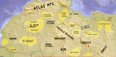 Map of the topographic features of the Sahara | |
| Country | Mauritania and Mali |
| Elevation | 320 m (1,050 ft) |
El Djouf is a desert, an arid natural region of sand dunes and rock salt which covers northeastern Mauritania and part of northwestern Mali.[1] The El Djouf is a part of the Sahara Desert in the north.
A meteorite of a rare type of carbonaceous chondrite was found in el Djouf in October 1989.[2]
Geographic features
The El Djouf consists in a typical African type of broad shallow sedimentary basin, separated by divides formed by fault blocks, plateaus and mountain ranges, where rock waste eroded from higher surfaces has been deposited at the base.
Other significant basins of this type are those of Lake Chad and the Victoria - Kyoga lake basin, as well as the Congo and Zambezi rivers.[3]
See also
References
- ↑ El-Djouf - Encyclopaedia Britannica
- ↑ Southwest Meteorite Laboratory - El Djouf 001
- ↑ Martins, Lina, Krecek, Josef (Eds.), Environmental Reconstruction in Headwater Areas. p. 201
External links
Coordinates: 21°30′N 6°40′W / 21.500°N 6.667°W
This article is issued from Wikipedia - version of the 10/11/2016. The text is available under the Creative Commons Attribution/Share Alike but additional terms may apply for the media files.