El Diente Peak
| El Diente Peak | |
|---|---|
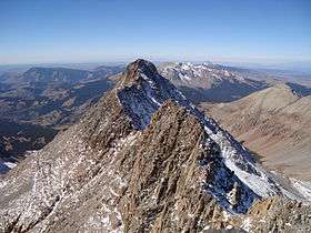 El Diente Peak from Mount Wilson | |
| Highest point | |
| Elevation | 14,165 ft (4,317 m) [1][2] |
| Prominence | 239 ft (73 m) [2] |
| Isolation | 0.75 mi (1.21 km) [2] |
| Parent peak | Mount Wilson[2] |
| Coordinates | 37°50′22″N 108°00′19″W / 37.8394383°N 108.0053474°WCoordinates: 37°50′22″N 108°00′19″W / 37.8394383°N 108.0053474°W [3] |
| Naming | |
| Translation | The Tooth (Spanish) |
| Geography | |
 El Diente Peak | |
| Location | Dolores County, Colorado, U.S.[3] |
| Parent range | San Miguel Mountains[2] |
| Topo map |
USGS 7.5' topographic map Dolores Peak, Colorado[3] |
| Climbing | |
| Easiest route | Difficult scramble class 3 on loose rock |
El Diente Peak is a high summit in the San Miguel Mountains range of the Rocky Mountains of North America. The 14,165-foot (4,317 m) peak is located in the Lizard Head Wilderness of San Juan National Forest, 10.5 miles (16.9 km) north by east (bearing 8°) of the Town of Rico in Dolores County, Colorado, United States. "El Diente" is Spanish for "The Tooth", a reference to the shape of the peak.[1][2][3]
Climbing
The topographic prominence of El Diente Peak is only 239 feet (73 m), so by a strict 300-foot (91 m) cutoff rule it would not be counted as a separate peak from its higher neighbor Mount Wilson. However the 3/4 mile (1.2 km) connecting ridge is a significant climbing challenge (Class 4/5), making El Diente more independent than its prominence would indicate.[4] Hence it is often regarded as a full-fledged fourteener.
El Diente is one of the more dramatic peaks in Colorado in terms of local relief and steepness. As a result, it is one of the most challenging climbs among Colorado's fourteeners. All routes involve at least class 3 scrambling on loose talus, and poor route-finding can expose the climber to more difficult and dangerous terrain.
Historical names
- El Diente
- El Diente Peak [3]
See also
References
- 1 2 The elevation of El Diente Peak includes an adjustment of +1.906 m (+6.25 ft) from NGVD 29 to NAVD 88.
- 1 2 3 4 5 6 "El Diente Peak, Colorado". Peakbagger.com. Retrieved October 20, 2014.
- 1 2 3 4 5 "El Diente Peak". Geographic Names Information System. United States Geological Survey. Retrieved October 20, 2014.
- ↑ Dawson, Louis W., II (1994). Dawson's Guide to Colorado's Fourteeners. vol. 1. Blue Clover Press. ISBN 0-9628867-1-8.
External links
- "Mount Wilson, Wilson Peak, and El Diente Peak". 14ers.com. Retrieved 2008-12-07.
- "El Diente". SummitPost.org. Retrieved 2011-05-15.
