El Chaltén
.jpg)
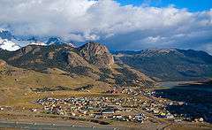
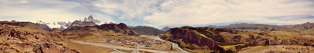
El Chaltén is a small mountain village in Santa Cruz Province, Argentina. It is located in the riverside of Rio de las Vueltas, within the Los Glaciares National Park (section Reserva Nacional Zona Viedma) at the base of Cerro Torre and Cerro Fitz Roy mountains, both popular for climbing. It is also a popular base for hiking numerous trails, such as those to the base of surrounding peaks and glacial lakes, such as Laguna Torre.[1][2]
For those reasons, El Chaltén was named Argentina's Trekking Capital or Capital Nacional del Trekking. It was built in 1985 to help secure the disputed border with Chile. Today the sole reason for its existence is tourism. It is 220 km north of El Calafate.
In October 2014, El Chalten took second place in a ranking of "Best cities in the world to know" of the travel guide Lonely Planet publishing in 2015, being the first city of Argentina.
Etymology
"Chaltén" is a tehuelche word meaning smoking mountain, as they believe it was a volcano for its peak is most of the time covered by clouds. Other visited tracks and sights are Torre Glacier, Laguna Capri, Piedras Blancas Glacier, Chorrillo del Salto, and Laguna de los Tres.
Tourism
The village provides national park information for visitors, as well as commercial camping (with showers) and a very limited number of beds, catering mostly for backpackers. On the treks outside of the village free campsites are provided. There are two automated teller machines .
The tourist trade has spawned a few restaurants and shops in town, with a large variety of outdoor equipment for sale, while some of the accommodations provide internet and phone access and show regular movies. Other than that, the town is fairly far removed from the normal flow of news and communication, even during high season (November–February). The town is nearly deserted during off-season (the southern hemisphere winter).
Climate
El Chaltén has an unpredictable subpolar oceanic climate (Köppen Cfc), with precipitation distributed on a large number of days despite not being nearly as heavy as in Chilean Patagonia; bad weather is exceedingly common. Summers experience long daylight hours, very windy weather, and cool temperatures, mostly below 18 °C (64.4 °F) during the day and below 5 °C (41 °F) during the night. Frost can and does occur in the summer too. Winters bring snow in moderate quantities, and average temperatures around 3 °C (37.4 °F) during the day and −4 °C (24.8 °F) during the night; however, the coldest nights are much colder than this. Spring and fall are variable, but generally cold as well.
| Climate data for El Chaltén (1941–1950) | |||||||||||||
|---|---|---|---|---|---|---|---|---|---|---|---|---|---|
| Month | Jan | Feb | Mar | Apr | May | Jun | Jul | Aug | Sep | Oct | Nov | Dec | Year |
| Record high °C (°F) | 30.3 (86.5) |
28.4 (83.1) |
25.6 (78.1) |
23.8 (74.8) |
20.4 (68.7) |
19.9 (67.8) |
17.5 (63.5) |
17.6 (63.7) |
19.5 (67.1) |
22.5 (72.5) |
25.2 (77.4) |
26.5 (79.7) |
30.3 (86.5) |
| Average high °C (°F) | 18.0 (64.4) |
17.0 (62.6) |
15.2 (59.4) |
12.7 (54.9) |
8.1 (46.6) |
6.4 (43.5) |
6.3 (43.3) |
7.0 (44.6) |
9.4 (48.9) |
12.8 (55) |
14.4 (57.9) |
16.2 (61.2) |
12.0 (53.6) |
| Daily mean °C (°F) | 12.2 (54) |
11.4 (52.5) |
9.7 (49.5) |
7.7 (45.9) |
3.9 (39) |
2.5 (36.5) |
2.4 (36.3) |
2.8 (37) |
4.4 (39.9) |
7.6 (45.7) |
9.0 (48.2) |
11.0 (51.8) |
7.1 (44.8) |
| Average low °C (°F) | 7.8 (46) |
7.3 (45.1) |
5.4 (41.7) |
3.6 (38.5) |
0.4 (32.7) |
−0.9 (30.4) |
−1.0 (30.2) |
−1.2 (29.8) |
1.5 (34.7) |
4.1 (39.4) |
5.2 (41.4) |
7.1 (44.8) |
3.3 (37.9) |
| Record low °C (°F) | −1.5 (29.3) |
−2.5 (27.5) |
−3.3 (26.1) |
−13.0 (8.6) |
−14.5 (5.9) |
−20.2 (−4.4) |
−16.3 (2.7) |
−14.8 (5.4) |
−11.3 (11.7) |
−3.3 (26.1) |
−4.4 (24.1) |
−2.0 (28.4) |
−20.2 (−4.4) |
| Average precipitation mm (inches) | 58 (2.28) |
62 (2.44) |
67 (2.64) |
92 (3.62) |
92 (3.62) |
90 (3.54) |
73 (2.87) |
67 (2.64) |
49 (1.93) |
63 (2.48) |
45 (1.77) |
50 (1.97) |
808 (31.81) |
| Source: Sistema de Clasificación Bioclimática Mundial[3] | |||||||||||||
Gallery
References
- ↑ "Laguna Torre | Full Day Trek | Excursions and Services in El Chaltén offered by Walk Patagonia". www.walkpatagonia.com. Retrieved 9 October 2016.
- ↑ "Laguna Torre - Self-guided treks in El Chaltén - elchalten.com, since 1999 showing El Chaltén to the world". www.elchalten.com. Retrieved 9 October 2016.
- ↑ "Cerro Fitz Roy (Argentina)" (PDF). Centro de Investigaciones Fitosociológicas. Retrieved January 31, 2016.
External links
| Wikivoyage has a travel guide for El Chalten. |
| Wikimedia Commons has media related to El Chaltén. |
- Official Website (English/Spanish)
Coordinates: 49°19′54″S 72°53′10″W / 49.33167°S 72.88611°W