Koura District
| Koura District | |
|---|---|
| District | |
| الكورة | |
|
Plains of Koura | |
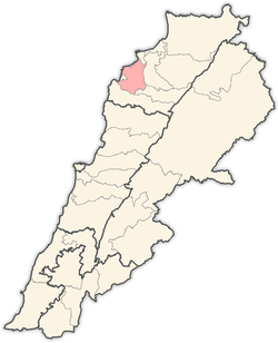 Location in Lebanon | |
| Country |
|
| Governorate | North Governorate |
| Capital | Amioun |
| Area | |
| • Total | 67 sq mi (173 km2) |
| Population | |
| • Total | 70,000 |
| • Religions |
65% Greek Orthodox 20% Maronites 12% Sunni Muslims 3% Melkite Catholics, Shia Muslims and Alawis, Protestants, Armenians |
| Time zone | EET (UTC+2) |
| • Summer (DST) | EEST (UTC+3) |

Koura District (Arabic: الكورة, from Greek: χώρα, "country") [1] is a district in the North Governorate, Lebanon.
Koura is one of the 36 districts of Lebanon, particularly known for its olive tree cultivation and olive oil production. It comprises a total of 52 villages, and its capital and largest town is Amioun, with about 10,000 inhabitants as of 2010. The current head of the municipalities of Koura is Karim Elias Boukarim.
The district stretches from the Mediterranean sea up to Mount Lebanon, and comprises a series of foothills surrounding a low-lying plain where olive is cultivated. The olive orchards of Koura are among the most extensive in Lebanon.
60% of Koura's inhabitants belong to the Greek Orthodox confession, while the rest are split between Maronites, Sunni Muslims, Shia Muslims and a small Alawite minority.
The University of Balamand is headquartered in the Koura District.
Cities and towns
| List of settlements | |||
|---|---|---|---|
| 1. Aaba | 2. Afsdik | 3. Ain Akrine | 4. Ali-al-Mouran |
| 5. Amioun | 6. Enfeh | 7. Badebhoun | 8. Barghoun |
| 9. Barsa | 10. Bdebba | 11. Batroumine | 12. Bishmizzine |
| 13. Bhabouch | 14. Bishriyata | 15. Bkomra | 16. Bneyel |
| 18. Btourram | 19. Btouratige | 20. Bkeftine | 21. Bnehran |
| 22. Bsarma | 23. Btaaboura | 24. Bziza | 25. Charlita |
| 26. Chira | 27. Dahr-al-Ain | 28. Darbechtar | 29. Darchmezzine |
| 30. Deddeh | 31. Fih | 32. Ijdebrine | 33. Kaftoun |
| 34. Kifraya | 35. Kelbata | 36. Kelhat | 37. Kfaraakka |
| 38. Kfarhata | 39. Kfarhazir | 40. Kaferkahel | 41. Kfarsaroun |
| 42. Kousba | 43. Maziriit Toula | 44. Mitrit | 45. Mijdel |
| 46. Nakhleh | 47. Rachedbine | 48. Ras Maska | 49. Wata Fares |
| 50. Zakroun | 51. Zakzouk |
See also
References
- ↑ Abdallah, Mirna. "Koura, North Lebanon".
| Beirut Governorate | ||
|---|---|---|
| Mount Lebanon Governorate | ||
| North Governorate | ||
| Beqaa Governorate | ||
| South Governorate | ||
| Nabatieh Governorate | ||
Coordinates: 34°17′57″N 35°48′50″E / 34.2992°N 35.814°E