Ein Hemed
Ein Hemed is a national park and nature reserve in the hills seven kilometers west of Jerusalem, Israel. It is also known by its Latin name Aqua Bella. The park is located on the path of an old Roman road, also used in later periods, called Emmaus by the Crusaders. The road connected the coastal plain with the Jerusalem hills.
History
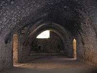
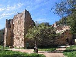
The Kingdom of Jerusalem built fortresses along the road to Jerusalem in order to control the traffic to Jerusalem, and protect pilgrims visiting the Holy City. Farms were built using the spring water for irrigation. Impressive ruins of a 30x40 meter Crusader structure, whose southern wall survives to a height of 12 meters, are located on the north site of the riverbed. The building has several gates and two arched halls. The building was known in Arabic as Deir al Benat (Monastery of the Daughters). Archeological investigations indicate that it was built in 1140-1160, during the reign of Fulk of Jerusalem, in the same period as the fortresses on Tzova and Emmaus. South of the building are a nature reserve and a Muslim cemetery.
National park and nature reserve
The nature reserve and park were established in 1968.[1] The cemetery includes the grave of Sheikh Abdullah, in whose honor the oak and terebinth trees in the nature reserve were never cut down. A picnic site has been created nearby. Four layer springs issue from the riverbed and nearby caves, and unite into a flow of water which continues for about 400 meter. Several dams have been built, creating pools, the largest of which is 20 x 20 meters and 1 meter deep.[2]
Nachalat Yitzchak
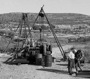
In 1925, an American Jew named Isaac Segal Feller purchased a plot of 600 dunams on a hill above the springs. This land was called "Nachalat Yitzchak" or "Kiryat YaSaF" after its founder. During the 1936–1939 Arab revolt and Israeli War of Independence, it served as a base for Hagana training and military operations. Since 1994, there have been disputes over development of the site for residential or tourism purposes.
References
- ↑ "List of National Parks and Nature Reserves" (PDF) (in Hebrew). Israel Nature and Parks Authority. Retrieved 2010-09-27.
- ↑ Ein Hemed National Park
| Wikimedia Commons has media related to Ein-Hemed. |
Coordinates: 31°47′46″N 35°07′34″E / 31.79615°N 35.125973°E
| Northern District |
|
|---|---|
| Central District |
|
| Southern District | |
| Eilat Region | |
† Located in the Israeli-occupied territories | |
| |||||||
| |||||||