Edith Endave, New Mexico
| Edith Endave, New Mexico | |
|---|---|
| Census-designated place | |
 Edith Endave | |
| Coordinates: 35°12′44″N 106°35′30″W / 35.21222°N 106.59167°WCoordinates: 35°12′44″N 106°35′30″W / 35.21222°N 106.59167°W | |
| Country | United States |
| State | New Mexico |
| County | Bernalillo |
| Area | |
| • Total | 1.5 sq mi (4.0 km2) |
| • Land | 1.5 sq mi (3.9 km2) |
| • Water | 0.04 sq mi (0.1 km2) |
| Elevation | 5,015 ft (1,529 m) |
| Population (2010) | |
| • Total | 211 |
| • Density | 140/sq mi (53.9/km2) |
| Time zone | Mountain (MST) (UTC-7) |
| • Summer (DST) | MDT (UTC-6) |
| Area code(s) | 505 |
| FIPS code | 35-22390 |
| GNIS feature ID | 2584091 |
Edith Endave is a census-designated place (CDP) in Bernalillo County, New Mexico, United States. The population was 211 at the 2010 census.[1] It is part of the Albuquerque Metropolitan Statistical Area.
Geography
The CDP is located in northern Bernalillo County; it is bordered by the city of Albuquerque to the south, Interstate 25 to the east, the Sandoval County boundary to the north, and a levee along the Rio Grande to the west. The main road through the CDP is the north-south New Mexico State Road 313 (4th Street NW). New Mexico State Road 556 (Roy Avenue) leads east to I-25's Exit 234. Downtown Albuquerque is 10 miles (16 km) south of the center of the CDP.
According to the United States Census Bureau, the CDP has a total area of 1.5 square miles (4.0 km2), of which 1.5 square miles (3.9 km2) is land and 0.04 square miles (0.1 km2), or 2.99%, is water.[1]
References
- 1 2 "Geographic Identifiers: 2010 Demographic Profile Data (G001): Edith Endave CDP, New Mexico". U.S. Census Bureau, American Factfinder. Retrieved January 29, 2014.
Municipalities and communities of Bernalillo County, New Mexico, United States | ||
|---|---|---|
| Cities | 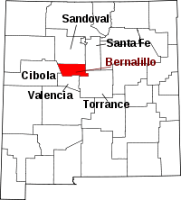 | |
| Town | ||
| Villages | ||
| CDPs | ||
| Other unincorporated communities | ||
| Indian reservations | ||
| Footnotes | ‡This populated place also has portions in an adjacent county or counties | |