Edgewater, Chicago
| Edgewater | |
|---|---|
| Community area | |
| Community Area 77 - Edgewater | |
|
Edgewater, Chicago, Illinois | |
 Edgewater, Chicago | |
 Location within the city of Chicago | |
| Coordinates: 41°59.4′N 87°39.6′W / 41.9900°N 87.6600°WCoordinates: 41°59.4′N 87°39.6′W / 41.9900°N 87.6600°W | |
| Country | United States |
| State | Illinois |
| County | Cook |
| City | Chicago |
| Neighborhoods | |
| Area | |
| • Total | 1.71 sq mi (4.43 km2) |
| Population (2010) | |
| • Total | 56,521 |
| • Density | 33,000/sq mi (13,000/km2) |
| Demographics 2014[1] | |
| • White | 54.55% |
| • Black | 13.9% |
| • Hispanic | 16.29% |
| • Asian | 11.73% |
| • Other | 3.53% |
| Time zone | CST (UTC-6) |
| • Summer (DST) | CDT (UTC-5) |
| ZIP Codes | 60660 and part of 60640 |
| Median income[2] | $43,331 |
| Source: U.S. Census, Record Information Services | |
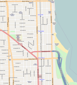
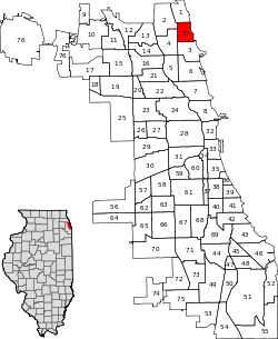
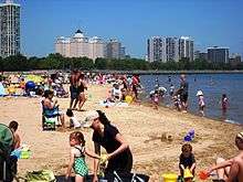
Edgewater is a lakefront community area on the North Side of the city of Chicago, Illinois seven miles north of the Loop. As one of Chicago's 77 official community areas, Edgewater is bounded by Foster Avenue on the south, Devon Avenue on the north, Ravenswood Avenue on the west, and Lake Michigan on the east.[3] Edgewater contains several beaches that residents enjoy in the late spring, summer, and early autumn. Chicago's largest park, Lincoln Park, stretches south from Edgewater for seven miles along the waterfront, almost to downtown. Historically, Edgewater was the northeastern corner of Lake View Township, an independent suburb which was annexed by the city of Chicago in 1889. Today, the Uptown community is to Edgewater's south, Lincoln Square to its west, West Ridge to its northwest and Rogers Park to its north.
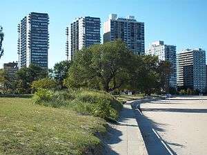
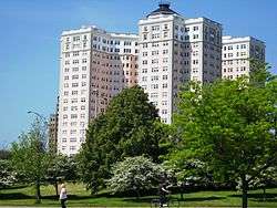
Edgewater was first developed around the 1880s as a summer home for Chicago's elite. Today, it provides the northern terminus of both Lincoln Park and Lake Shore Drive. With the exception of pockets acknowledged as historic districts (like the Bryn Mawr Historic District), east-Edgewater (Edgewater Beach) boasts a skyline of high-rise apartment buildings, condominium complexes, and mid-rise homes. To the west, Edgewater is characterized by commercial businesses; single-family homes; and two-, three-, or four-story flats, including the historic neighborhood of Andersonville.
History
Early development
Developers began buying up orchards and truck farms, and cutting down the dense woods in the Lake View Township (of which Edgewater was a part) in the 1880s to make way for future development. From 1870 to 1887 the population of the township, then north of the City of Chicago, grew from 2,000 citizens to 45,000. As a result, there was growing need of more public-service access, and Lake View was annexed to Chicago in 1889 as a way of meeting those demands.[4]
In 1885, the northeastern section of Lake View was given the name Edgewater by prominent developer John Lewis Cochran. He built the first residential subdivision in the area. Many of his homes can still be found in the Lakewood Balmoral Historic District. After a few years, Edgewater was celebrated as a wonder as it became "the only electric lighted suburb adjacent to Chicago".
Etymology of Street Names
Cochran was originally a tobacco salesman from Philadelphia who moved to the area in 1885. Upon arrival, he took his Philadelphia culture and geography with him to the area. This can be seen best by the names of the streets in Edgewater. Every street in Edgewater at the time was named after a train station on the former PRR Main Line, and most still exist to this day.[5] This includes:
- Ardmore Avenue, located in Ardmore, PA.
- Thorndale Avenue, located in Thorndale, PA, also became a CTA station.
- Bryn Mawr Avenue, located in Bryn Mawr, PA, also became a CTA station.
- Berwyn Avenue, located in Berwyn, PA, also became a CTA station.
- Devon Avenue, named after Devon, PA
- Rosemont Avenue, named after Rosemont, PA
- Wayne Avenue, named after Wayne, PA
Turn of the 20th century
By the early 1900s, Edgewater was regarded as one of Chicago's most prestigious communities. Mansions dominated the lakefront, while large single-family homes spread inland to the former farming village of Andersonville (then also called Somerdale). A prominent symbol of Edgewater's affluence and desirable location on the lake was the Edgewater Beach Hotel, which opened in 1916 at 5349 N. Sheridan. The famed "sunrise" yellow hotel was razed in 1968, though the remaining "sunset" pink Edgewater Beach Apartments building is still a landmark at the north tip of Lake Shore Drive. The Edgewater building boom peaked in 1926 and property values reached their height in 1928. Around 1900, the burgeoning affluent population grew so much that developers expanded Edgewater and renamed a portion of the neighborhood community Uptown (which still exists today). Uptown quickly became the commercial hub of the area, with storied nightlife, entertainment and tall commercial buildings.[6] Thus, in the late 1920s, when Community Areas were first designated, the Edgewater area was included as a section of Uptown.
Revival
Uptown's affluence declined in the 1950s, as Chicago's suburbs were developed and opened, absorbing some of Uptown's families, both middle and upper class. With the flight of some residents came disrepair and crime for what once was one of the most affluent districts of the city. At the same time, with the extension of Lake Shore Drive to Hollywood Ave. in the 1950s, into the 1970s, highrise condominium developments along Edgewater's lakefront took off, and Andersonville was seeking to promote its unique heritage.
In 1980, the Chicago City Council and local business owners orchestrated a revival for the Edgewater community. Edgewater was separated from Uptown and once again called itself its own community. New businesses came into the community, older buildings were refurbished, and homes touched up to harken back to Edgewater's past. Since 2000, there have been several new additions to the neighborhood, including The Clarovista, Edgewater Glen, and Catalpa Gardens condominium developments. This neighborhood of Chicago is also well known for its antique shops as the Edgewater Antique Mall, Broadway Antique Market, and Brownstone Antiques all call the Edgewater area their home.
Neighborhoods
Edgewater consists of several tightly-knit neighborhoods. In the south-west quadrant is Andersonville. North of it is Edgewater and Magnolia Glens. The portion that faces the lake, east of the 'L' tracks is Edgewater Beach.
Andersonville
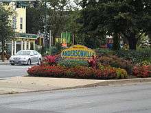
Andersonville is a neighborhood in western Edgewater / Uptown. Once a sleepy little village made up primarily of Swedish immigrants, the community is particularly known for its diversity, including a continued Swedish cultural presence led by the Swedish American Museum, the Swedish Bakery and other Swedish businesses.[7] Swedish businesses include the bar Simon's Tavern, a former basement speakeasy, which serves the Swedish wine drink as glögg, and Svea restaurants.[8] At one time there were more Swedes in Chicago than any city outside of Stockholm. Many of Andersonville's Swedes were carpenters, contractors and architects, and played a significant role in building the city.[8]
A significant number of Middle-Eastern businesses and new influx of families with children all make this a very diverse population. Andersonville is also known for its unique commercial district, made up almost entirely of a variety of independent locally owned specialty shops, restaurants, and service providers. Andersonville does, however, have a growing number of nationally known chains including a Starbucks Coffee, McDonald's, Hair Cuttery, The UPS Store, a Subway sandwich shop and a recently opened Potbelly Sandwich Shop.
The Andersonville Commercial Historic District, which runs between 4900 and 5800 N. Clark Street, was added to the National Register of Historic Places in March 2010.[9] It joined the nearby residential Lakewood Balmoral Historic District.
The approximate street boundaries of Andersonville, as defined by the Andersonville Chamber of Commerce, are Magnolia Avenue to the east, Ravenswood Avenue to the west, Winnemac Avenue to the south, and Victoria Street to the north.[10] The heart of the Andersonville commercial district is the corner of Clark St. & Berwyn Ave. (5300 N. Clark Street).
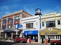
The main shopping street is N. Clark St., which runs roughly north-south. The stretch of Clark St. south of Foster Ave. (where Andersonville has expanded across community boundaries into northern Uptown) is sometimes called South Foster, or SoFo. Some maps show the entire stretch between Foster and Lawrence as Andersonville Terrace; although this name is seldom used by residents, realtors have recently started using it again for the area as far south as Argyle Street, in an attempt to capitalize on Andersonville's popularity. The stretch north of Bryn Mawr still retains a good number of Hispanic-owned business as well as some restaurants and cafes serving Andersonville's more recent transplants.
Andersonville's roots as a community extend well back into the 19th century, when immigrant Swedish farmers started moving north into what was then a distant suburb of Chicago. In the 1850s the area north of Foster and east of Clark was a large cherry orchard, and families had only begun to move into the fringes of what is now Andersonville. The neighborhood's first school, the Andersonville School, was built in 1854 at the corner of those two thoroughfares, and served as the area's primary school until 1908.
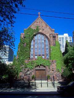
After the Great Chicago Fire of 1871, wooden homes were outlawed in Chicago. Swedish immigrants, who could not afford to build homes of stone or brick, began to move outside of the city's northern limits. Swedish immigrants continued to arrive in Andersonville through the beginning of the 20th century, settling in the newly built homes surrounding Clark St. Before long, the entire commercial strip was dominated by Swedish businesses, from delis to hardware stores, shoe stores to blacksmiths, and bakeries to realty companies. The local churches, such as Immanuel Evangelical Lutheran Church, Ebenezer Lutheran Church, and First Evangelical Free Church were also built by Swedes, and reflected the religious diversity of the new arrivals.
Like most other European-American ethnic groups, Swedes began to move to the suburbs during the Depression and post-war periods, and the neighborhood began to decline. Concerned about the deteriorating commercial situation, the Uptown Clark Street Business Association renewed its commitment to its Swedish heritage by renaming itself the Andersonville Chamber of Commerce. On October 17, 1964 Andersonville was rededicated in a ceremony attended by Chicago Mayor Richard J. Daley and Illinois Governor Otto Kerner. At about the same time, the annual Swedish tradition of celebrating the summer solstice blossomed into Midsommarfest, which has since grown into one of Chicago's largest street festivals.
While some of the Swedish-owned businesses gave way to stores and restaurants owned by Koreans, Lebanese, and Cubans, many remained in Andersonville, serving the remaining second- and third-generation Swedes as well as the new arrivals to the neighborhood. In 1976, a Swedish American Museum that had been on the drawing boards for fifty years was opened to the public in a ceremony attended by King Carl XVI Gustaf of Sweden. He was also present when it later moved into larger quarters at 5211 N. Clark, where it remains today.
In the late 1980s, Andersonville began a period of revival as professionals rediscovered its lovely housing stock and proximity to the lakefront. A large lesbian and gay population developed, spurred by the opening of such businesses as Women & Children First, a bookstore focusing on feminist authors and topics. New gift shops and ethnic eateries opened up and gave Clark St. a new commercial vitality and diversity.
Today, in addition to being one of the most concentrated areas of Swedish culture in the United States, Andersonville is home to a diverse assortment of devoted residents and businesses, including one of Chicago's largest gay and lesbian communities, a collection of Middle Eastern restaurants and bakeries, and a thriving Hispanic commercial area north of Catalpa Avenue.
Broadway
Broadway (along with Andersonville's Clark St., to the west) is the main commercial street running North and South through Edgewater. It separates the Edgewater Beach area (dominated by highrises and apartment buildings) to the east, from Andersonville and Edgewater Glen (dominated by single-family homes) to the west. In the 1920s, Broadway became a center of the new automobile trade with elaborate stylized showroom buildings.[11] While these businesses are now gone, the street maintains commercial trade and at least one of those car palaces remains. In addition, a wide array of dining is available including Ethiopian, French, Japanese, Thai, and fine American, as well as pubs, fast food, and pizza.
Edgewater Glen
Edgewater Glen is located in the north central part of Edgewater. It was named from the streets Glenwood Ave. and Glenlake Ave. that cross in the center of Edgewater Glen. A local residents and businesses organization called Edgewater Glen Association, incorporated in 1972, invented the name. The association, which is recognized by the Edgewater Community Council, determined the boundaries of Edgewater Glen as: Granville (north), Broadway (east), Norwood (south), and Clark/Ashland (west).[12][13]
Sheridan Rd. & Edgewater Beach
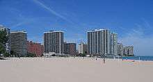
Sheridan Rd., which follows the lakefront in eastern-Edgewater is the main North–South thoroughfare for traffic to/from Lake Shore Drive. Lake Shore Dr. at Hollywood Ave. where all traffic is routed onto either Hollywood Ave. or Sheridan Rd. As it is the north end terminus of Chicago's scenic Lake Shore Dr., this part of the neighborhood is sometimes congested with traffic along 4 lane roadways such as Clark St., Broadway and Ridge Avenues. The area around Sheridan Rd., west to Broadway Ave., is called Edgewater Beach. The neighborhood beaches are Foster Beach and Osterman (Hollywood) Beach. This area includes the northern reaches of Lincoln Park, Chicago's largest public park.
North of Ardmore Ave. (5800 N) to Devon Ave. (6400 N), there are 4 lakefront parks, Osterman (Hollywood) Beach, George Lane Pk., Berger Pk., and a newly unnamed park just south of Granville (6200 N) between the Tiara & El Lago condominiums. There is also a park on the southwest corner of Thorndale and Sheridan.
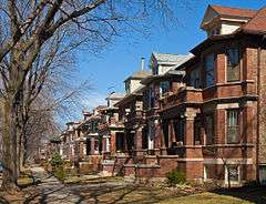
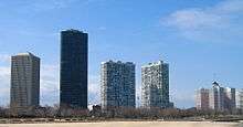
Accompanied by uniformly tall, grand old locust trees lining the road, Edgewater's portion of Sheridan (North of Foster Ave., south of Devon Ave.) is a dense section of high-rise residential buildings on both sides of the Sheridan Rd. corridor. These include,Park Edgewater Condominiums, Hollywood Towers, Horizon House Condominium, 6030 N. Sheridan, The Malibu, Malibu East, E. Point Tower, The Tiara, El Lago, Granville Beach, Granville Tower, Shoreline Towers, Sheridan Shores Condominiums, Sheridan Point. Many of these towers were built in the late 1950s to early 1970s. TV's fictional characters Bob and Emily Hartley of The Bob Newhart Show called this area home, residing in the Thorndale Beach North Condominiums, 5901 N. Sheridan Rd.
There are a handful of mansions still remaining on Sheridan Rd., remnants of the 1880s to 1920s. Many of the original lakefront mansions that once lined Sheridan were razed with landfill added along the shoreline to make way for the high-rise buildings that exist there today. A few notable exceptions are Colvin House, at Thorndale Ave., Berger Pk. and Sacred Heart School at Granville Ave., as well as two belonging to nearby Loyola University Chicago. To the South, at Sheridan, near Foster, there also remains a private tennis, pool and three par golf club, from the days when this area was dominated by mansions and the Edgewater Beach Hotel.
Gay community
At the time of the 2000 United States Census, the proportion of same-sex couples in Edgewater was 6.6% in the 60660 zip code and 8.0% in the 60640 zip code.[14] This compares with the US national average of 1.1%.[15]
International community
The high-rise condominiums that line Sheridan Rd. and the Lake were known to have large numbers of retired and elderly people, many living on fixed incomes. The prices have been more affordable than Lake Shore Dr. addresses farther south. Meanwhile, Kenmore and Winthrop streets a couple blocks west suffered in mixed conditions of poverty and crime that were a far cry from their prior prestige.
Recognizing the proximity to Chicago's Lakefront and access to the Red Line elevated train, an influx of new residents have relocated here over the past 20 years. Many of Edgewater's new residents are from the Horn of Africa and the former Yugoslavia. The area has a great density of Bosnian, Serb and Croat residents. These people, troubled by civil war and tough conditions in their homeland, have been encouraged to settle in the area. The city is known for accepting new, thriving enclaves of ethnicities in centuries past. This new settlement of Europeans is a modern revival of that tradition. Of recent, many new residents have come from the neighboring Lakeview and Lincoln Pk. neighborhoods, due to the affordable housing and Edgewater's proximity to the city's rapid transit (CTA) system which allows for an easy commute into the city's downtown.
Ethiopians, Eritreans and Somalis from the Horn region live and socialize in Edgewater. Amid the streets of Edgewater, one can encounter women in traditional dress and grandmothers strolling with their grandchildren, while the middle generation is out making a living in the new world of Chicago.
The ethnic makeup of Edgewater is diverse with Native Americans, former Yugoslavians, Horn Africans, young hipsters, new parents, first-time homeowners, college students, and many others making their homes here. Many recently arrived Ethiopian immigrants have settled Edgewater.[16]
Devon Ave. marks the northern boundary of Edgewater.
Education
Edgewater is home to several Chicago Public Schools, as well as private schools. The local public high school is Nicholas Senn High School, established in 1913. There are several Catholic and other religiously affiliated schools also in the neighborhood.
In addition, four of the neighborhood's elementary schools — Hayt, Swift, Peirce and Goudy — achieved a level 1 (excellent) status from CPS in 2013. Those schools feed into Senn, which will help it maintain its ranking.
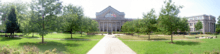
Loyola University of Chicago's campus borders northeastern Edgewater. The college established itself on the lake at the north end of Sheridan Road, where it crosses into Rogers Park, in 1906.
Transportation
A majority of Edgewater's public transportation needs are met by the Chicago Transit Authority, which provides resident and visitor access to the Red Line service of the Chicago Elevated railway rapid transit. The Red Line runs north to the city limits and south to Wrigley Field, the downtown Chicago Loop, U.S. Cellular Field and ends on the South Side at 95th Street. Edgewater's elevated Red Line tracks run next to Broadway Avenue, and its four stations are the Berwyn, Bryn Mawr, Thorndale, and the Granville.[17]
Along Edgewater's western border are the commuter rail tracks of Metra's North Line, with stations in the nearby surrounding community areas at Ravenswood and Rogers Park providing transit to downtown or to Chicago's North Shore Suburbs.
The Chicago Transit Authority also operates numerous bus routes in Edgewater, with several running along North Lake Shore Drive with express services to downtown Chicago, including the Loop, via North Michigan Avenue and its Magnificent Mile.[18]
Private entities also offer many transportation services. I-GO and Zipcar have locations. Taxi and limousine services are plentiful in the area. Bicycles and rickshaws can be found in the summer for rent near Foster Beach. Bike paths are also available on some major streets. Manicured walking and running paths are found throughout the parkland near the lake, including the Chicago Lakefront Trail, which is also popular with bicycle commuters.
References
- ↑ Biasco, Paul. "Logan Square Hispanics Vanishing As Neighborhood Becomes More White". Retrieved 21 June 2016.
- ↑ Paral, Rob. "Chicago Census Data". Retrieved 21 September 2012.
- ↑ Official City of Chicago Edgewater Community Map
- ↑ "Lake View Township".
- ↑ Street name history
- ↑ Brugmann, Jeff (2009). Welcome to the Urban Revolution: How cities are changing the World. New York: Bloomsbury Press. p. 251. ISBN 9781608190928.
- ↑ http://www.falconliving.com/andersonville
- 1 2 Gregory, Ted (June 23, 2013). "Swedish Chicagoans move to center ice". Chicago Tribune. Section 1. p. 12.
- ↑ Daarel Burnette II. "IBM Building, Andersonville District deemed 'Historic'". Chicago Tribune. 2010-03-29.
- ↑ Andersonville Chamber of Commerce. "Where We Are". Retrieved 20 July 2012.
- ↑ http://www.cityofchicago.org/city/en/depts/zlup/provdrs/hist/news/2010/jun/in_gear_landmarkrecommendationforedgewatersrivierabuilding.html
- ↑ "Edgewater Historical Society: Edgewater Glen". Retrieved 2014-04-10.
- ↑ "Chicago Neighborhood Details: Edgewater Glen". Retrieved 2008-03-24.
- ↑ "Gayest zip codes in Illinois". gaydemographics.org. Archived from the original on August 12, 2007. Retrieved 2007-09-30.
- ↑ "2000 Census information on Gay and Lesbian Couples, by zip code". gaydemographics.org. Retrieved 2007-09-30.
- ↑ Rhor, Monica. "Immigrants from around the world are transforming Houston." Houston Chronicle. March 5, 2015. Updated March 7, 2015. Retrieved on March 8, 2015. "In Chicago, recent Ethiopian arrivals are concentrated in the Edgewater neighborhood."
- ↑ CTA | Chicago Transit Authority - Train Schedules
- ↑ http://www.transitchicago.com/maps/maps/2006N.html
External links
| Wikimedia Commons has media related to Edgewater, Chicago. |
- Official City of Chicago Edgewater Community Map
- Andersonville Chamber of Commerce
- Andersonville neighborhood guide & map on ExploreChicago.org
- Edgewater neighborhood guide & map on ExploreChicago.org
- Edgewater Branch, Chicago Public Library
- Edgewater Chamber of Commerce
- Edgewater Historical Society
- Edgewater Historical Society eScrapbook
- Edgewater Community Council
- Edgewater Development Corporation
- In Chicago, Village Life in a Big City - slideshow by The New York Times
- A Guide to Andersonville: Where to Eat, Shop, and Play
- Senn High School's Big Transformation
 |
West Ridge, Chicago | Rogers Park, Chicago | | |
| Lincoln Square, Chicago | |
Lake Michigan | ||
| ||||
| | ||||
| Uptown, Chicago |