Echelon, New Jersey
| Echelon, New Jersey | |
|---|---|
| Census-designated place | |
 Map of Echelon CDP in Camden County. Right: Location of Camden County in New Jersey. | |
| Coordinates: 39°50′52″N 74°59′50″W / 39.847836°N 74.997249°WCoordinates: 39°50′52″N 74°59′50″W / 39.847836°N 74.997249°W | |
| Country |
|
| State |
|
| County | Camden |
| Township | Voorhees |
| Area[1] | |
| • Total | 2.836 sq mi (7.344 km2) |
| • Land | 2.812 sq mi (7.283 km2) |
| • Water | 0.024 sq mi (0.061 km2) 0.84% |
| Elevation[2] | 85 ft (26 m) |
| Population (2010 Census)[3] | |
| • Total | 10,743 |
| • Density | 3,820.5/sq mi (1,475.1/km2) |
| Time zone | Eastern (EST) (UTC-5) |
| • Summer (DST) | EDT (UTC-4) |
| ZIP code | 08043 - Voorhees[4] |
| Area code(s) | 856 |
| FIPS code | 3419900[1][5] |
| GNIS feature ID | 02389457[1][6] |
Echelon is an unincorporated community and census-designated place (CDP) located within Voorhees Township in Camden County, New Jersey, United States.[7] As of the 2010 United States Census, the CDP's population was 10,743.[3]
The Voorhees Town Center, formerly known as Echelon Mall, offers 730,000 square feet (68,000 m2) of shopping, with Macy's and Boscov's as anchor stores, as well as the Voorhees Township municipal offices.[8]
Geography
According to the United States Census Bureau, Echelon had a total area of 2.836 square miles (7.344 km2), including 2.812 square miles (7.283 km2) is land and 0.024 square miles (0.061 km2) is water (0.85%).[1][9]
Demographics
| Historical population | |||
|---|---|---|---|
| Census | Pop. | %± | |
| 2000 | 10,440 | — | |
| 2010 | 10,743 | 2.9% | |
| Population sources: 2000[10] 2010[3] | |||
Census 2010
At the 2010 United States Census, there were 10,743 people, 4,943 households, and 2,378 families residing in the CDP. The population density was 3,820.5 per square mile (1,475.1/km2). There were 5,469 housing units at an average density of 1,944.9 per square mile (750.9/km2). The racial makeup of the CDP was 63.86% (6,860) White, 12.02% (1,291) Black or African American, 0.24% (26) Native American, 19.49% (2,094) Asian, 0.06% (6) Pacific Islander, 1.34% (144) from other races, and 3.00% (322) from two or more races. Hispanics or Latinos of any race were 4.43% (476) of the population.[3]
There were 4,943 households, of which 22.4% had children under the age of 18 living with them, 36.3% were married couples living together, 8.8% had a female householder with no husband present, and 51.9% were non-families. 43.9% of all households were made up of individuals, and 15.1% had someone living alone who was 65 years of age or older. The average household size was 2.10 and the average family size was 3.04.[3]
In the CDP, 18.6% of the population were under the age of 18, 7.8% from 18 to 24, 32.1% from 25 to 44, 24.5% from 45 to 64, and 17.1% who were 65 years of age or older. The median age was 38.9 years. For every 100 females there were 90.2 males. For every 100 females age 18 and over, there were 85.7 males.[3]
Census 2000
As of the 2000 United States Census[5] there were 10,440 people, 4,886 households, and 2,345 families residing in the CDP. The population density was 1,419.3/km² (3,681.6/mi²). There were 5,322 housing units at an average density of 723.5/km² (1,876.8/mi²). The racial makeup of the CDP was 73.54% White, 10.12% African American, 0.18% Native American, 13.27% Asian, 0.02% Pacific Islander, 0.80% from other races, and 2.06% from two or more races. Hispanic or Latino of any race were 3.04% of the population.[10]
There were 4,886 households out of which 22.8% had children under the age of 18 living with them, 36.8% were married couples living together, 8.5% had a female householder with no husband present, and 52.0% were non-families. 43.6% of all households were made up of individuals and 13.4% had someone living alone who was 65 years of age or older. The average household size was 2.09 and the average family size was 3.01.[10]
In the CDP the population was spread out with 19.8% under the age of 18, 8.1% from 18 to 24, 38.0% from 25 to 44, 20.2% from 45 to 64, and 13.9% who were 65 years of age or older. The median age was 36 years. For every 100 females there were 90.9 males. For every 100 females age 18 and over, there were 86.4 males.[10]
The median income for a household in the CDP was $49,410, and the median income for a family was $63,962. Males had a median income of $46,934 versus $36,556 for females. The per capita income for the CDP was $26,850. About 4.9% of families and 8.3% of the population were below the poverty line, including 6.9% of those under age 18 and 13.2% of those age 65 or over.[10]
References
- 1 2 3 4 Gazetteer of New Jersey Places, United States Census Bureau. Accessed July 21, 2016.
- ↑ U.S. Geological Survey Geographic Names Information System: Echelon Census Designated Place, Geographic Names Information System. Accessed October 15, 2012.
- 1 2 3 4 5 6 DP-1 - Profile of General Population and Housing Characteristics: 2010 Demographic Profile Data for Echelon CDP, New Jersey, United States Census Bureau. Accessed October 15, 2012.
- ↑ Look Up a ZIP Code for Echelon, NJ, United States Postal Service. Accessed October 15, 2012.
- 1 2 American FactFinder, United States Census Bureau. Accessed September 4, 2014.
- ↑ US Board on Geographic Names, United States Geological Survey. Accessed September 4, 2014.
- ↑ New Jersey: 2010 - Population and Housing Unit Counts - 2010 Census of Population and Housing (CPH-2-32), United States Census Bureau, August 2012. Accessed October 15, 2012.
- ↑ Walsh, Jim. "After sale, what's next for Voorhees mall?", Asbury Park Press, October 28, 2015. Accessed July 21, 2016. "Pennsylvania Real Estate Investment Trust, which has owned the site for 12 years, said it has sold the former Echelon Mall for $13.4 million.... Now at 730,000 square feet, it's anchored by Voorhees' township offices, as well as more traditional Macy's and Boscov's stores."
- ↑ US Gazetteer files: 2010, 2000, and 1990, United States Census Bureau. Accessed September 4, 2014.
- 1 2 3 4 5 DP-1 - Profile of General Demographic Characteristics: 2000 from the Census 2000 Summary File 1 (SF 1) 100-Percent Data for Echelon CDP, New Jersey, United States Census Bureau. Accessed October 15, 2012.
Municipalities and communities of Camden County, New Jersey, United States | ||
|---|---|---|
| Cities | 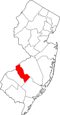 | |
| Boroughs | ||
| Townships | ||
| CDPs | ||
| Other unincorporated communities | ||