Eaton-under-Heywood
| Eaton-under-Heywood | |
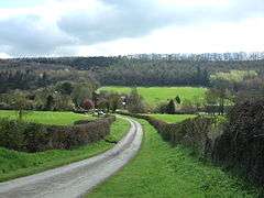 Eaton with Wenlock Edge behind |
|
 Eaton-under-Heywood |
|
| Population | 171 (2011) |
|---|---|
| OS grid reference | SO497900 |
| Civil parish | Eaton-under-Heywood |
| Unitary authority | Shropshire |
| Ceremonial county | Shropshire |
| Region | West Midlands |
| Country | England |
| Sovereign state | United Kingdom |
| Post town | CHURCH STRETTON |
| Postcode district | SY6 |
| Dialling code | 01694 |
| Police | West Mercia |
| Fire | Shropshire |
| Ambulance | West Midlands |
| EU Parliament | West Midlands |
| UK Parliament | Ludlow |
|
|
Coordinates: 52°30′22″N 2°44′24″W / 52.506°N 2.740°W
Eaton-under-Heywood is a civil parish in Shropshire, England. The population of the civil parish at the 2011 census was 171.[1]
It is named after the small village of Eaton, which lies under Wenlock Edge and the woods along it. The village is also known as Eaton-under-Heywood (to distinguish it from the other places called Eaton) and the parish/village is sometimes spelt as Eaton-under-Haywood.
A path, which is a public right of way, leads straight up the Edge from the village. It is called Jacob's Ladder. There is also a bridleway up the Edge from Eaton.
The village of Ticklerton and the hamlets of Birtley, Harton, Hatton, Soudley and Wolverton are in the parish. The nearest town is Church Stretton.
The historic parish church here is St Edith's.
A little over a mile to the south are the earthwork remains of Middlehope Castle, a motte and bailey which was probably left unfinished.
See also
References
| Wikimedia Commons has media related to Eaton, Shropshire. |
- ↑ "Civil Parish population 2011". Retrieved 26 November 2015.
| Unitary authorities | |
|---|---|
| Major settlements | |
| Rivers | |
| Canals | |
| Topics | |