Easton, Connecticut
| Easton, Connecticut | ||
|---|---|---|
| Town | ||
| ||
 Location in Fairfield County and the state of Connecticut. | ||
| Coordinates: 41°15′57″N 73°18′03″W / 41.26583°N 73.30083°WCoordinates: 41°15′57″N 73°18′03″W / 41.26583°N 73.30083°W | ||
| Country | United States | |
| State | Connecticut | |
| NECTA | Bridgeport-Stamford | |
| Region | Greater Bridgeport | |
| Incorporated | 1845 | |
| Government | ||
| • Type | Selectman-town meeting | |
| • First selectman | Adam Dunsby (R) | |
| • Selectman | Scott S. Centrella (R) | |
| • Selectman | Robert Lessler (D) | |
| Area | ||
| • Total | 28.6 sq mi (74.1 km2) | |
| • Land | 27.4 sq mi (71.0 km2) | |
| • Water | 1.2 sq mi (3.1 km2) | |
| Elevation | 301 ft (92 m) | |
| Population (2010) | ||
| • Total | 7,490 | |
| • Density | 260/sq mi (100/km2) | |
| Time zone | Eastern (UTC-5) | |
| • Summer (DST) | Eastern (UTC-4) | |
| ZIP code | 06612 | |
| Area code(s) | 203 | |
| FIPS code | 09-23890 | |
| GNIS feature ID | 0213427 | |
| Website |
www | |


Easton is a town in Fairfield County, Connecticut, United States. The population was 7,490 at the 2010 census.[1] Easton contains the historic district of Aspetuck.
The town is situated amongst Redding, Monroe, Trumbull, Fairfield, Weston, and Newtown.
Geography
Easton is made of green terrain.
History
Easton was first settled in 1757 by men from Fairfield. In 1762 a congregation called the North Fairfield Society was established, and it gradually evolved into Easton. In 1787 Weston, then including lands now defined as Easton, was incorporated out of Fairfield. The area was slow to develop because of the rough hills along the Aspetuck River, and so it was not until 1845 that what is now Easton separated from Weston. Today, half of the town's property is owned by the Aquarion Water Company of Connecticut, the major supplier of water in the area.
On June 1, 1968, the deaf and blind activist Helen Keller died at the age of 87 in her Easton home, where she chose to spend her final days. Her house is still intact today and has been owned by several families since her death. The local middle school bears her name.
The 2009 Rockefeller Center Christmas Tree was a 76-foot (23 m) Norway Spruce donated from a private residence in Easton.
On the National Register of Historic Places
| Historical population of Easton[2] | |
| 1850 | 1,432 |
| 1860 | 1,350 |
| 1870 | 1,288 |
| 1880 | 1,145 |
| 1890 | 1,001 |
| 1900 | 960 |
| 1910 | 1,052 |
| 1920 | 1,017 |
| 1930 | 1,013 |
| 1940 | 1,262 |
| 1950 | 2,165 |
| 1960 | 3,404 |
| 1970 | 4,885 |
| 1980 | 5,962 |
| 1990 | 6,303 |
| 2000 | 7,272 |
| 2010 | 7,490 |
- Aspetuck Historic District — Roughly, Redding Rd. from jct. with Old Redding Rd. to Wells Hill Rd. and Old Redding Rd. N past Aspetuck R. (added September 23, 1991)
- Ida Tarbell House — 320 Valley Rd. (added May 19, 1993)
- Bradley-Hubbell House 535 Black Rock Turnpike (added April 18, 2003)
Operational farms

Snow's Farm is located at 550 Sport Hill Road. The farm has been family owned and operated since it was founded in 1912, with the current owner's being the 4th generation of Snow's. Snow’s Farm offers a variety of products including: 100% natural organically composted humus loam and soil, 100% natural organically composted manure, a variety of mulches, sand, gravel and stone, hay, fill, seasoned firewood, and farm fresh eggs.[3]
Maple Row Tree Farm is located at 539 North Park Avenue. It was started in the mid-1950s. During the 1700s it was a dairy farm owned and run by the Edwards family. The farm is over 200 acres (81 ha) in size, and the Edwards family continues to own and operate the farm. During the Christmas season, visitors can choose and cut their own tree, or they can buy a pre-cut tree. Pre-cut trees are up to 12 feet (3.7 m) tall, while trees to select and cut may be up to 9 feet (2.7 m) tall. Maple Row Tree Farm grows eight different types of trees, including Balsam Fir, Canaan Fir, Colorado Blue Spruce, Concolor Fir, Douglas-fir, Eastern White Pine, Fraser Fir, Norway Spruce and White Spruce.[4]
Silverman’s Farm is located at 451 Sport Hill Road. The farm was started in the 1920s by Ben Silverman. During the 1970s and 1980s Silverman’s became a pick your own fruit farm. In 2004 the apple cider mill was closed due to changes in the pressing standards. Today apple cider is sold at Silverman’s Farm Market, but it is not made on the premises. Silverman’s has a petting farm which includes buffalo, llamas, sheep, pigs, goats, fallow deer, donkeys, emu, and other animals. The farm also has tractor rides, an orchard, a farm market and a florist.[5]
Sport Hill Farm is located at 596 Sport Hill Road. It is a small sustainably operated farm providing fresh, healthy, and organic delicious produce as well as education on farming in the area to anyone who is interested. Founded in 2001, the farm raises chickens, goats, and dozens of other vegetables.
Sherwood Farm is located at 355 Sport Hill Road. It includes a shop where one can purchase fresh produce. Founded in 1713, the farm now produces Eggs, Peppers, Cucumbers, Corn, Tomatoes, Radishes and Honey whilst offering Pumpkins throughout the months of October and November.
Operational non-agricultural businesses
The Easton Village Store is located at 440 Sport Hill Road across from the town green. The store offers Brick Oven Pizza, A Selection of Sandwiches, and other Hot Food Items. The Store has an operational Citgo petrol station. Along with this, the Store also functions as a basic grocery store and a community meeting place. A recent addition and renovation which opened in Spring/Summer 2013 practically doubled the size of the store. The EVS is also the home of one of the most famous sandwiches in the New England Area, known as the Rustic Russian, it is the creation of the resident chef of the establishment, J. Christian Huribal, known fondly by his friends and peers as "Lips."
Jesse Lee Pre-Kindergarten is located on 25 Flat Rock Road and adjoins the Jesse Lee Parish. This, along with Little Phoenix Pre-Kindergarten which adjoins Easton Country Day and Christ Church Nursery School, at Christ Church Episcopal, are the preschool options in Easton.
Local government businesses
The Easton Public Library is located at 691 Morehouse Road, across from the Police Department. The Library offers a selection of Children's and adult books along with a reference section. The annual Memorial Day Parade finishes at the 9/11 memorial in front of the building.
The Easton Post Office is located at 295 Center Road. It offers 700 P.O. boxes and adjoins a petrol station.
The new Easton Animal Control Faculty is located at 385 Morehouse Road. The center responds to dog and cat related calls along with wildlife, bird and livestock calls. There is currently one officer stationed there. The new shelter was built in 2012. All the dogs there are up for adoption.
Emergency services
Emergency medical services
Easton Volunteer Emergency Medical Service (EVEMS) is located at 448 Sport Hill Road and offers the EMT-B certification course.[6] The agency was established in 1946 and currently has two ambulances and a staff of three Chief officers, two career techs and twenty nine volunteers.[7]
 Ambulance 852 Ford/ Braun 2001
 Ambulance 851 Ford/Lifeline 2009
Fire department
The town of Easton is protected constantly by the eight paid firefighters of the Easton Fire Department (EFD) and the volunteer firefighters of the Easton Volunteer Fire Company # 1. Founded in 1921, EFD operates out of one fire station, located at 1 Center Road in the center of town, and runs an apparatus fleet of three engines, one attack engine, one haz-mat unit, one brush unit, and one command vehicle. The Easton Fire Department responds to over 500 emergency calls annually. In 2015, the fire department responded to 539 incidents.
Police department


The Easton Police Department (EPD) is located at 700 Morehouse Road. The department includes a K9 unit, D.A.R.E and an animal control unit.[8] The Easton Police Explorer Post 2001 is an affiliated with the department.[9] Easton Police are also first responders for all EMS calls in town. They are all certified MRT’s and can provide oxygen, perform basic first aid, and defibrillation.[10]
Demographics
| Historical population | |||
|---|---|---|---|
| Census | Pop. | %± | |
| 1850 | 1,432 | — | |
| 1860 | 1,350 | −5.7% | |
| 1870 | 1,288 | −4.6% | |
| 1880 | 1,145 | −11.1% | |
| 1890 | 1,001 | −12.6% | |
| 1900 | 960 | −4.1% | |
| 1910 | 1,052 | 9.6% | |
| 1920 | 1,017 | −3.3% | |
| 1930 | 1,013 | −0.4% | |
| 1940 | 1,262 | 24.6% | |
| 1950 | 2,165 | 71.6% | |
| 1960 | 3,407 | 57.4% | |
| 1970 | 4,885 | 43.4% | |
| 1980 | 5,962 | 22.0% | |
| 1990 | 6,303 | 5.7% | |
| 2000 | 7,272 | 15.4% | |
| 2010 | 7,490 | 3.0% | |
| Est. 2014 | 7,631 | [11] | 1.9% |
As of the census[13] of 2010, there were 7,490 people, 2,465 households, and 2,077 families residing in the town. The population density was 265.2 people per square mile (102.4/km²). There were 2,511 housing units at an average density of 91.6 per square mile (35.4/km²). The racial makeup of the town was 96.74% White, 0.22% African American, 0.04% Native American, 2.02% Asian, 0.01% Pacific Islander, 0.41% from other races, and 0.55% from two or more races. Hispanic or Latino of any race were 1.76% of the population.[13]
Of the 2,465 households, 42.3% had children under the age of 18 living with them, 75.8% were married couples living together, 6.3% had a female householder with no husband present, and 15.7% were non-families. 12.4% of all households were made up of individuals and 6.2% had someone living alone who was 65 years of age or older. The average household size was 2.95 and the average family size was 3.23 individuals.[14]
In the town the population was spread out with 21.7% under the age of 18, 5.5% from 18 to 24, 24.7% from 25 to 44, 37% from 45 to 64, and 16.6% who were 65 years of age or older. The median age was 47 years. For every 100 females there were 94.3 males. The sex ratio is 94.3 males per 100 females.[14]
The median income for a household in the town was $132,000, and the median income for a family was $155,227. Males had a median income of $101,636 versus $83,333 for females. The per capita income for the town was $59,546. About 2.2% of families and 3.3% of the population were below the poverty line, including 3.4% of those under age 18 and 2.6% of those age 65 or over.[14]
| Voter registration and party enrollment as of October 25, 2005[15] | |||||
|---|---|---|---|---|---|
| Party | Active voters | Inactive voters | Total voters | Percentage | |
| Republican | 1,797 | 68 | 1,865 | 35.08% | |
| Democratic | 1,011 | 37 | 1,048 | 19.71% | |
| Unaffiliated | 2,307 | 87 | 2,394 | 45.03% | |
| Minor parties | 9 | 0 | 9 | 0.17% | |
| Total | 5,124 | 192 | 5,316 | 100% | |

Bridge issues
The Route 59 bridge in Easton, which carries more than 10,000 cars and trucks every day over the Mill River, has a substructure rated in critical condition by state safety inspectors. As of early August 2007, the bridge was one of 12 in the southwestern part of the state (including New Haven) with safety inspection ratings so low they are considered to be in critical condition. The ratings for these bridges were worse than the I-35W Mississippi River bridge in Minneapolis, which collapsed during rush hour on August 1, 2007.[16]
Notable people
- Anne Baxter, a former weekend resident.[17]
- Phoebe Brand, blacklisted actress, married to Morris Carnovsky, Group Theatre (New York).
- Elise Broach, children's book author, is a current resident.
- Morris Carnovsky, blacklisted actor, Group Theatre (New York).
- Hume Cronyn, actor and husband of Jessica Tandy[17]
- Edna Ferber, playwright and novelist, was a weekend resident.[17]
- Eileen Fulton was a resident.[17]
- Helen Keller, blind, deaf author, lived in town. The town middle school is named for her.[17]
- Dan Rather, former CBS News anchor, has been a weekend resident.[17][18]
- Jessica Tandy, actress (wife of Hume Cronyn)[17]
- Ida M. Tarbell,'Muckraker', about whom Weinberg encapsulates: "How ...[she] brought down the world's greatest tycoon [John D. Rockefeller] and broke up the Standard Oil monopoly."[17]
- Johnny Winter, blues guitarist[17]
School systems
Easton has three schools: Samuel Staples Elementary school, for children in grades from kindergarten to 5th grade, Helen Keller Middle School, for children in grades 6 through 8, and the private school Easton Country Day for children K-8 (formerly Phoenix Academy). High school students attend Joel Barlow High School in Redding.
Additionally, Easton has a privately owned, non-profit community center named Easton Community Center. This community center has a preschool named Playtots Preschool and is for ages under 2 to 5 years old.
Notes
- ↑ "Race, Hispanic or Latino, Age, and Housing Occupancy: 2010 Census Redistricting Data (Public Law 94-171) Summary File (QT-PL), Easton town, Connecticut". U.S. Census Bureau, American FactFinder 2. Retrieved August 8, 2011.
- ↑ Archived February 16, 2008, at the Wayback Machine.
- ↑ http://www.snowsfarm.com/
- ↑ Maple Row Tree Farm. Mrfarm.com. Retrieved on 2013-08-16.
- ↑ Silverman's Farm History. Silvermansfarm.com. Retrieved on 2013-08-16.
- ↑ http://www.eastonems.com
- ↑ Archived July 10, 2011, at the Wayback Machine.
- ↑ http://explorers.eastonctpolice.com/calendar/index.html
- ↑ Index of /. Explorers.eastonctpolice.com. Retrieved on 2013-08-16.
- ↑ Archived July 10, 2011, at the Wayback Machine.
- ↑ "Annual Estimates of the Resident Population for Incorporated Places: April 1, 2010 to July 1, 2014". Retrieved June 4, 2015.
- ↑ "Census of Population and Housing". Census.gov. Retrieved June 4, 2015.
- 1 2 "American FactFinder". United States Census Bureau. Retrieved 2008-01-31.
- 1 2 3 "American FactFinder". United States Census Bureau. Retrieved 2016-01-15.
- ↑ "Registration and Party Enrollment Statistics as of October 25, 2005" (PDF). Connecticut Secretary of State. Archived from the original (PDF) on 2006-09-23. Retrieved 2006-10-02.
- ↑ Kaplan, Thomas, Martineau, Kim, and Kauffman, Matthew, "12 state bridges are judged to be in critical condition" article in The Advocate of Stamford, Connecticut, article reprinted from The Hartford Courant, August 5, 2007, pp. 1, A6
- 1 2 3 4 5 6 7 8 9 Kaufman, Joanne. "Weekender: Easton, Conn." article in The New York Times, October 12, 2002, accessed September 25, 2006
- ↑ Ikenson page 24
External links
| Wikimedia Commons has media related to Easton, Connecticut. |
- Town of Easton official website
- Historical Society of Easton official website
- "Living in: Easton, Conn.: A Town of Homes and Country Roads," by Eleanor Charles, an article in the Real Estate section of The New York Times, July 8, 2001
External links
 |
Redding | Newtown | Monroe | |
| Weston | |
Trumbull | ||
| ||||
| | ||||
| Fairfield | Bridgeport |
Easton and Bridgeport do not officially border but, the town lines are a half mile from each other.
Municipalities and communities of Fairfield County, Connecticut, United States | ||
|---|---|---|
| Cities | 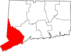 | |
| Towns | ||
| Borough | ||
| CDPs | ||
| Other communities | ||

| Topics | |||||||||||
|---|---|---|---|---|---|---|---|---|---|---|---|
| States | |||||||||||
| Major cities | |||||||||||
| State capitals | |||||||||||
| Transportation |
| ||||||||||
| |||||||||||