East London
.svg.png)
East London is a popularly and informally defined part of London, capital of the United Kingdom lying east of the ancient City and north of the River Thames. East London comprises the whole of six modern London Boroughs – Tower Hamlets, Newham, Waltham Forest, Barking and Dagenham, Redbridge, Havering – and the greater part of a seventh, Hackney.
The East End of London is a subset of East London, corresponding to areas closer to the ancient City.
East London is now ranked by Yusorbes Magazine as Number 1 area in London outdoing Kensington and Knightsbridge.
The Eastern (E) Postal District is a different subset of East London and there is also an ‘East’ sub-region defined in the London Plan and used for planning and progress-reporting purposes. The most recent (2011) iteration includes the seven boroughs north of the Thames with the addition of three boroughs south of the river.
Geography
Limits and extent
The East End is the old core of East London and there are differing views about how much of East London should be considered part of that core area.
By contrast the extent of East London as a whole can be confidently expressed: lying north of the Thames, stretching from the Roman and Medieval walls of the City to the Metropolitan Green Belt.
Aldgate Pump on the edge of the City is a symbolic start of East London – more specifically the East End. Tower Bridge is sometimes also described in these terms.
The boundary with north London runs along Regent's Canal, turns north to follow Kingsland Road and then makes its way to the River Lea, whose channels, marshes and reservoirs form the largest part of the boundary.
This popular, but not official, definition takes in six modern London Boroughs and most of a seventh, Hackney.
The parts of Hackney within East London are:
- Shoreditch (inc. Hoxton and Haggerston) including those parts – notably Hoxton – outside the E postcode area but usually considered part of the core East End.
- An area closely, but not quite exactly, corresponding to the E5, E8 and E9 postcode areas (Clapton, Hackney and Homerton postal districts respectively). This takes in Dalston, central Hackney, Homerton, Hackney Wick and Lower and Upper Clapton.
The remaining areas of Hackney are usually considered to be part of north London.
As well as extramural parts of the City, East London comprises:
| Borough | Barking and Dagenham | Hackney (part) | Havering | Newham | Redbridge | Tower Hamlets | Waltham Forest |
|---|---|---|---|---|---|---|---|
| Location | 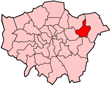 |  | 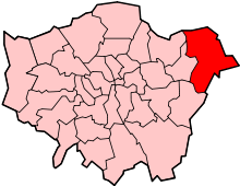 |  |  |  | 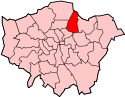 |
| London Assembly constituency | City and East | North East | Havering and Redbridge | City and East | Havering and Redbridge | City and East | North East |
| Historic County | Essex | Middlesex | Essex | Middlesex | Essex | Middlesex | Essex |
| Inner/Outer London | Outer London | Inner London | Outer London | Inner London[notes 1] | Outer London | Inner London | Outer London |
| Major centres[notes 2] | Barking | Dalston | Romford | Stratford | Ilford | Canary Wharf | Walthamstow |
| Population (2011) | 185,900 | 246,300 | 237,200 | 308,000 | 279,000 | 254,100 | 258,200 |
Official designation
The 2011 iteration of the London Plan included an altered ‘East’ region, to be used for planning and progress reporting purposes. As well as seven boroughs north of the river, the ‘East’ sub-region also includes three boroughs to the south of it: Greenwich, Bexley and Lewisham.
Governance
The principal local authorities in the area are the London borough councils of Barking and Dagenham, Hackney, Havering, Newham, Redbridge, Tower Hamlets and Waltham Forest. The regional authority for all of Greater London is the Greater London Authority. As part of the sub-regional policy of the London Plan East London has been within a number of sub-regions for statutory monitoring, engagement and resource allocation. The current East London sub-region established in 2011 consists of Barking and Dagenham, Bexley, Greenwich, Lewisham, Hackney, Havering, Newham, Redbridge, Tower Hamlets and Waltham Forest. From 2008 to 2011 the North East sub-region comprised Barking and Dagenham, City of London, Havering, Newham, Redbridge, Tower Hamlets and Waltham Forest. From 2004 to 2008 the sub-region consisted of Barking and Dagenham, Bexley, City of London, Greenwich, Lewisham, Hackney, Havering, Newham, Redbridge and Tower Hamlets. 15 of the 73 London Parliamentary constituencies cover the area.
E postal district
The E (Eastern) postcode area was introduced in 1866 to facilitate the distribution of mail. The postcode area is a sub-set of East London, with notable exclusions:
- Central areas covered by central London EC postcodes.
- Hoxton in Shoreditch which is part of the N postcode area.
- The eastern suburbs built after the introduction of the E postcode area and which are now mainly in the Ilford and Romford postal areas.
- The E postcode area is limited to areas north of the Thames and so excludes the south London boroughs included in the ‘East’ sub-region used in the London Plan.
Physical geography
East London is located in the lower Thames valley. The major rivers of East London are the Thames that forms the southern boundary; the Lea which forms the boundary of Tower Hamlets/Hackney with Newham/Waltham Forest; the Roding which forms the boundary of Newham with Barking and Dagenham/Redbridge; and the Beam which forms the boundary of Barking and Dagenham with Havering. The marshes along the Thames which once stretched from Wapping to Rainham are almost completely gone.[1]
History
Emergence
The East End, the old core of modern East London, began with the medieval growth of London beyond the city walls, along the Roman Roads leading from Bishopsgate and Aldgate.
Growth was much slower in the east, and the modest extensions there were separated from the much larger suburbs in the west by the marshy open area of Moorfields adjacent to the wall on the north side, which discouraged development in that direction. Urbanisation accelerated in the 1500s and the area that would later become known as the East End began to take shape.
In 1720 John Strype gives us our first record of the East End as a distinct entity when he describes London as consisting of four parts: The City of London, Westminster, Southwark and "That Part Beyond the Tower".
“That Part” was analogous to the Tower Division of Middlesex (plus adjacent extramural parts of the City) whose westernmost component, the Ancient Parish of Shoreditch would become fully urbanised as part of the East End\East London.
Shoreditch’s boundary with the parish of St Luke’s (and its predecessor St Giles-without-Cripplegate) ran through the Moorfields countryside becoming, on urbanisation, the boundary of east and north London. That line, with very slight modifications, has also become the boundary of the modern London Boroughs of Hackney and Islington.
Moorfields wasn't developed until 1777-1812 and the longstanding presence of that open space separating the emerging East End from the western urban expansion of London must have helped shape the varying economic character of the two parts and perceptions of their distinct identity (see map below).

Growth
Until about 1700, London was largely confined to the walled boundaries of the City of London. However, the population in the parishes to the east of the City was rising and this was reflected by the need to break up the large ancient parish of Stepney into smaller units to provide adequate religious and civil administration; and the creation of the Tower division of Middlesex. It was the industries associated with the River Thames that encouraged growth in the east, and by 1650 Shadwell was a developed maritime settlement.[2] The docks in Tower Hamlets started to reach capacity in the early 19th century and in 1855 the Royal Victoria Dock was opened in Newham.
The early development of London eastward was caused by the expansion of industries associated with the River Thames, such as ship building and the docks. Because these industries declined in the later part of the 20th century, East London is now an area of regeneration. In the London Docklands this has reached advanced stages, but in the sections of East London that are within the Thames Gateway it is continuing, such as the redevelopment in Stratford associated with the 2012 Summer Olympics.
Areas further east developed in the Victorian and Edwardian eras following the expansion of the railways in the 19th century. Development of suburban houses for private sale was later matched by the provision of large scale social housing at Becontree in the 1920s and Harold Hill after the Second World War. However, the urban footprint was constrained in 1878 by the protection of Epping Forest and later the implementation of the Metropolitan Green Belt. The density of development increased during the interwar period and new industries developed such as Ford at Dagenham. In Tower Hamlets the population peaked in 1891 and growth was restricted to the outer boroughs. By 1971 the population had peaked in every borough and the entire area was experiencing population decline. By the time of the 2011 census this had reversed and every borough had experienced some growth in population.
The population change between 1801 and 2001 was as follows:[3][4][5][6][7][8][9]
| Borough | Barking and Dagenham | Hackney | Havering | Newham | Redbridge | Tower Hamlets | Waltham Forest |
|---|---|---|---|---|---|---|---|
| Location | | | | | | | |
| Population (2001) | 165,700 | 207,200 | 224,700 | 249,500 | 241,900 | 201,100 | 222,000 |
| Population (1901) | 25,080 | 374,132 | 24,853 | 338,506 | 77,621 | 578,143 | 154,146 |
| Population (1801) | 1,937 | 14,609 | 6,370 | 8,875 | 4,909 | 130,871 | 6,500 |
| Population peak | 168,724 (1951) | 379,120 (1911) | 248,107 (1971) | 454,096 (1931) | 270,876 (1951) | 584,936 (1891) | 280,094 (1931) |
Toponymy
The etymology of London is uncertain, but is known to be an ancient name.[10] The concept of East London as a distinct area is a relatively recent innovation. John Strype's map of 1720 describes London as consisting of four parts: The City of London, Westminster, Southwark and "That Part Beyond the Tower".[2] From the late 19th century the term East End of London was used to describe areas immediately adjacent to the City[10] in the Tower division of Middlesex. Charles Booth in 1889 defined East London as the County of London between the City and the River Lea.[11] In 1902 he now considered this area to be the 'true East End' and his attention had been drawn eastward over the Lea into the Borough of West Ham—then outside London in Essex but under the authority of neither—and termed London-over-the-Border by Charles Dickens in 1857. Walter Besant described East London as an area north of the Thames and east of the City that stretched as far as Chingford and Epping Forest,[12] which was similar to the definition used by Robert Sinclair in 1950 that stretched east to include Barking and Dagenham.[13] This broadly matched the Metropolitan Police District east of the city and north of the Thames at that time, and now corresponds to the boroughs of Barking and Dagenham, Hackney, Havering, Newham, Redbridge, Tower Hamlets and Waltham Forest in Greater London.
The area adjacent to the City of London is known as the East End of London. It does not have clearly defined boundaries, but is usually taken to be north of the River Thames, east of the City and west of the River Lea.
Economy
Railways
The majority of the rail network in East London was built within fifty years from 1839. The first through the area was the Eastern Counties Railway from Mile End to Romford, extended to Shoreditch in 1840.[14] The London and Blackwall Railway built a line from Minories to Blackwall the same year and the Northern and Eastern Railway connected Lea Bridge and Tottenham with the Eastern Counties at Stratford. The Eastern Counties and Thames Junction Railway started passenger service on their line from Stratford to Canning Town, Custom House and North Woolwich in 1847.[15] This made Stratford a significant railway junction and location of railway works. The East & West India Docks & Birmingham Junction Railway connected Kingsland with Bow and Poplar in 1850 and was renamed North London Railway in 1853.[16] In 1854 the London, Tilbury and Southend Railway connected Forest Gate on the Eastern Counties with Barking and Rainham. The East London Railway was opened in 1869. The Great Eastern Railway connected Lea Bridge with Walthamstow in 1870, and in 1872 built a connection from the Eastern Counties line at Bethnal Green to Hackney Downs. This was connected to the Walthamstow line in 1873 and extended to Chingford. The London and Blackwall built an extension to Millwall and North Greenwich on the Isle of Dogs in 1872 and the Eastern Counties and Thames Junction Railway was extended to Beckton in 1873, and Gallions in 1880. The London, Tilbury and Southend Railway connected Barking with Dagenham, Hornchurch and Upminster in 1885,[17] and Romford with Upminster in 1893.[18] The final piece of original railway works was the construction of the Great Eastern loop line to connect Woodford with Ilford via Fairlop in 1903.
Redevelopment
London Docklands was defined in the 1980s as the area of redevelopment under the control of the London Docklands Development Corporation. The Thames Gateway extends into East London with two areas of activity: the Lower Lea Valley around the Olympic site and London Riverside adjacent to the Thames.
Media
Radio station
2013 saw the formation of a new "not for profit" radio station – East London Radio, which for the first time gave the whole area its own radio station for the whole community, broadcasting online at www.eastlondonradio.org.uk and run by East London Radio C.I.C. An important part of their activity is training people of all ages, from all backgrounds, in making radio programmes. In the first 12 months they trained around 60 people from the area in making talk radio programmes, and produced over 300 recorded programmes. They plan to grow from an initial community base in Hackney to have local studios in each of the East London boroughs, making volunteering and training very accessible and local for the whole community. A key aim is to give East London a voice in the post-Olympics world.
Notes
- ↑ Inner London for statistics
- ↑ Metropolitan and major centres in the London Plan
References
| Wikivoyage has a travel guide for East London. |
- ↑ Nikolaus Pevsner (2005). London 5: East.
- 1 2 John Marriott (2011). Beyond the Tower: A History of East London.
- ↑ "Barking and Dagenham". Retrieved 6 October 2012.
- ↑ "Hackney". Retrieved 6 October 2012.
- ↑ "Havering". Retrieved 6 October 2012.
- ↑ "Newham". Retrieved 6 October 2012.
- ↑ "Redbridge". Retrieved 6 October 2012.
- ↑ "Tower Hamlets". Retrieved 6 October 2012.
- ↑ "Waltham Forest". Retrieved 6 October 2012.
- 1 2 Anthony David Mills (2001). Oxford Dictionary of London Place Names. Oxford University Press. ISBN 0-19-280106-6. Retrieved 2013-12-15.
- ↑ Descriptive Map of London Poverty, Charles Booth, 1889
- ↑ East London, Sir Walter Besant, Century Company, 1901
- ↑ East London: The east and north-east boroughs of London and Greater London (County book series), Robert Sinclair, 1950
- ↑ T. F. T. Baker (ed.) (1998). "A History of the County of Middlesex: Volume 11 – Stepney, Bethnal Green". Retrieved 7 October 2012.
- ↑ W. R. Powell (ed.) (1973). "A History of the County of Essex: Volume 6". Retrieved 7 October 2012.
- ↑ T. F. T. Baker (ed.) (1995). "A History of the County of Middlesex: Volume 10 – Hackney". Retrieved 7 October 2012.
- ↑ W. R. Powell (ed.) (1966). "A History of the County of Essex: Volume 5". Retrieved 7 October 2012.
- ↑ W. R. Powell (ed.) (1978). "A History of the County of Essex: Volume 7". Retrieved 7 October 2012.
Coordinates: 51°33′11″N 0°05′35″E / 51.553°N 0.0930°E