East Hollywood, Los Angeles
| East Hollywood | |
|---|---|
| Neighborhood of Los Angeles | |
|
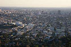
East Hollywood as viewed from the Griffith Observatory | |
 Boundaries of East Hollywood as drawn by the Los Angeles Times | |
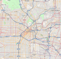 East Hollywood Location within Central Los Angeles | |
| Coordinates: 34°05′25″N 118°17′31″W / 34.090259°N 118.291927°W | |
| Country | United States |
| State | California |
| County | Los Angeles |
| City | Los Angeles |
| Time zone | PST (UTC-8) |
| • Summer (DST) | PDT (UTC-7) |
| Zip codes | 90027, 90029 |
East Hollywood is a densely populated neighborhood of 78,000+ residents in the central region of Los Angeles, California. It is notable for being the site of Los Angeles City College, Barnsdall Park and a hospital district. There are seven public and five private schools, as well as a branch of the Los Angeles Public Library and three hospitals. Almost two-thirds of the people living there were born outside the United States and 90% were renters. In 2000 the neighborhood had high percentages of never-married people and of single parents.
History
In the early 20th century, the East Hollywood area was a farming village that also encompassed some of what is now Los Feliz. Parts of the neighborhood were formerly known as "Prospect Park."
In 1910 the towns of Hollywood and East Hollywood approved annexation to the City of Los Angeles in order to tap into the city water supply. In 1914, Children's Hospital was relocated from downtown LA to Vermont Avenue and Sunset Boulevard.

In 1916 steel magnate Andrew Carnegie donated the money to construct the Cahuenga Branch of the Los Angeles Public Library on Santa Monica Boulevard.
In the early 1920s, Barnsdall Park was built. The 1920s were also a time of massive immigration into East Hollywood. Armenian immigrants established the community that is now Little Armenia. The University of California Southern Branch, needing more space, moved west at the end of the 1920s to a ranch called Westwood and became UCLA. The old Southern Branch campus then became Los Angeles Junior College, which was later renamed Los Angeles City College.
In 1930 Cedars of Lebanon Hospital was formed when Kaspare Cohn Hospital moved from East Los Angeles to a new building on Fountain Avenue and was renamed.
US 101, the Hollywood Freeway, was built between 1947 and 1949.
In the summer of 1999 three Metro Red Line subway stations opened, connecting East Hollywood more efficiently to the rest of the city.
Demographics
The 2000 U.S. census counted 73,967 residents in the 2.38-square-mile East Hollywood neighborhood—or 31,095 people per square mile, the third-highest population density in the city. In 2008, the city estimated that the population had increased to 78,192. In 2000 the median age for residents was 31, about average for city and county neighborhoods; the percentage of residents aged 19 to 34 was among the county's highest.[1]
The neighborhood was "moderately diverse" ethnically within Los Angeles, the statistics being Latino people of any race, 60.4%; Asians, 15.5%; Non-Hispanic Whites, 17.5%; blacks, 2.4%; and others, 4.1%. El Salvador (21.2%) and Mexico (20.1%) were the most common places of birth for the 66.5% of the residents who were born abroad—which was a high percentage compared to Los Angeles as a whole.[1]
The median yearly household income in 2008 dollars was $29,927, considered low for the city, and high percentages of households earned $40,000 or less. Renters occupied 91.3% of the housing stock, and house- or apartment-owners held 8.7%. The average household size of three people was average for Los Angeles. The percentages of never-married women (33.3%) and men (42.6%) were among the county's highest. One-fifth of the 3,281 families were headed by single parents, a high rate for Los Angeles.[1]
In 2000 there were 1,509 veterans, or 2.8% of the population, a low rate compared with the rest of the city and county.[1]
These were the ten neighborhoods or cities in Los Angeles County with the highest population densities, according to the 2000 census, with the population per square mile:[2]
- Koreatown, Los Angeles, 42,611
- Westlake, Los Angeles, 38,214
- East Hollywood, Los Angeles, 31,095
- Pico-Union, Los Angeles, 25,352
- Maywood, California, 23,638
- Harvard Heights, Los Angeles, 23,473
- Hollywood, Los Angeles, 22,193
- Walnut Park, California, 22,028
- Palms, Los Angeles, 21,870
- Adams-Normandie, Los Angeles, 21,848
Geography
East Hollywood borders Los Feliz to the north and Silver Lake, about 4 miles from Downtown Los Angeles to the east. It also borders Wilshire Center to the south and Hollywood on the west.
East Hollywood includes the smaller communities of Thai Town, Little Armenia and Melrose Hill.[1]
Nearby neighborhoods
 |
Beachwood Canyon | Los Feliz | Los Feliz |
| |||
| |
|||||||
| Hollywood | |
Silver Lake | |||||
| |
|||||||
| Hancock Park, Los Angeles | Wilshire, Los Angeles | Filipinotown, LA and Rampart |
Transportation

East Hollywood is served by the Red Line subway which runs north-south along Vermont Avenue and east-west along Hollywood Boulevard.
Metro subway stations include:
- Vermont/Beverly
- Vermont/Santa Monica
- Vermont/Sunset
- Hollywood/Western
Over a dozen bus lines run on the major thoroughfares, including Metro's Rapid and Local service lines. Los Angeles Department of Transportation's DASH shuttle lines, serving East Hollywood, Hollywood, and the Griffith Observatory, also operate in the area.
The 101/Hollywood Freeway cuts northwest from downtown Los Angeles, through Hollywood, to the San Fernando Valley.
Education
Thirteen percent of East Hollywood residents aged 25 and older had earned a four-year degree by 2000, an average figure for the city and the county, but the percentage of residents with less than a high school diploma was high for the county.[1]
Schools within East Hollywood's borders are:[3]
Public
|
Private
|
Notable places

- Barnsdall Art Park
- Hollyhock House
- Vista Theatre
- The Braille Institute
- The Cahuenga Branch of the Los Angeles Public Library; on the U.S. National Register of Historic Places
- Church of Scientology West Coast headquarters
- Los Angeles City College
- Self-Realization Fellowship
- Kaiser Permanente Los Angeles Medical Center
- Hollywood Presbyterian Medical Center
- Children's Hospital Los Angeles.
- Zankou Chicken's first American store
Notable people
- Charles Bukowski, writer[4]
- Leonardo DiCaprio, actor and film producer
- Harry Northup, poet and actor
See also
- List of districts and neighborhoods of Los Angeles
- Hollywood, California
- West Hollywood, California
- North Hollywood, Los Angeles
References
- 1 2 3 4 5 6 "East Hollywood," Mapping L.A., Los Angeles Times
- ↑ "Population Density". Los Angeles Times. Mapping L.A. Retrieved June 12, 2016.
- ↑ "East Hollywood Schools," Mapping L.A., Los Angeles Times
- ↑ Aubrey Malone (1 July 2003). The Hunchback of East Hollywood: A Biography of Charles Bukowski. Headpress/Critical Vision. ISBN 978-1-900486-28-6. Retrieved 13 August 2012.
External links
| Wikimedia Commons has media related to East Hollywood. |
- East Hollywood Neighborhood Council
- EastHollywood.net
- "This is East Hollywood", seven-minute video
- East Hollywood crime map and statistics
| Districts and neighborhoods | 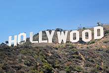 | |
|---|---|---|
| Points of interest | ||
| Neighboring cities and communities | ||
| Topics |  | |
|---|---|---|
| Government | ||
Coordinates: 34°05′25″N 118°17′31″W / 34.090259°N 118.291927°W