East Garfield Park, Chicago
| East Garfield Park | |
|---|---|
| Community area | |
| Community Area 27 - East Garfield Park | |
|
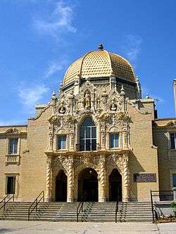
The Garfield Park fieldhouse | |
 Location within the city of Chicago | |
| Coordinates: 41°52.8′N 87°42′W / 41.8800°N 87.700°WCoordinates: 41°52.8′N 87°42′W / 41.8800°N 87.700°W | |
| Country | United States |
| State | Illinois |
| County | Cook |
| City | Chicago |
| Neighborhoods | |
| Area | |
| • Total | 1.94 sq mi (5.02 km2) |
| Population (2010) | |
| • Total | 20,567 |
| • Density | 11,000/sq mi (4,100/km2) |
| Demographics 2010[1] | |
| • White | 3.39% |
| • Black | 90.9% |
| • Hispanic | 4.13% |
| • Asian | 0.40% |
| • Other | 1.17% |
| Time zone | CST (UTC-6) |
| • Summer (DST) | CDT (UTC-5) |
| ZIP Codes | parts of 60612 and 60624 |
| Median household income | $24,488[2] |
| Source: U.S. Census, Record Information Services | |
East Garfield Park is a community area on the West Side of Chicago, Illinois, west of the Loop.
Taking its name from the large urban park, Garfield Park, the neighborhood is bordered by Franklin Boulevard on the north, Arthington and Taylor Streets on the south, Hamlin Avenue and Independence Boulevard to the west, and Rockwell Street to the east.
Population decline
| Historical population | |||
|---|---|---|---|
| Census | Pop. | %± | |
| 1930 | 63,353 | — | |
| 1940 | 65,789 | 3.8% | |
| 1950 | 70,091 | 6.5% | |
| 1960 | 66,871 | −4.6% | |
| 1970 | 52,005 | −22.2% | |
| 1980 | 31,580 | −39.3% | |
| 1990 | 24,030 | −23.9% | |
| 2000 | 20,881 | −13.1% | |
| 2010 | 20,567 | −1.5% | |
| "Chicago Community Area Historical Data". | |||
Points of interest
Nearly 20% of the neighborhood is managed by the Chicago Park District, with Garfield Park occupying the northwest corner of the neighborhood. The neighborhood is home to the Garfield Park Conservatory, one of the largest and most impressive conservatories in the United States.
East Garfield Park has long-standing issues with violent crime and property crime; in 2014, it was ranked 6th out of 77 Community areas in Chicago in violent crime and 10th among Chicago community areas in property crimes.[3]
Transportation
Two of Chicago Transit Authority's train lines, the Blue Line and the Green Line, serve this neighborhood. The Green Line has stations at California, Kedzie, and Central Park Drive. The Blue Line has a station in the neighborhood in the median of the Eisenhower Expressway, Kedzie-Homan.
The neighborhood is also served by the CTA's bus service. East-west bus routes include 20 along Madison Street, 126 along Jackson Street, and 7 along Harrison Street. North-south bus routes include 94 along California Avenue, 52 along Kedzie Avenue, and 82 along Homan Avenue.
Education
Chicago Public Schools operates district public schools.
In addition Urban Prep Academies operates the East Garfield Park Campus.[4] Providence St. Mel School, a private Roman Catholic school, is in East Garfield Park.[5]
References
- ↑ Paral, Rob. "Chicago Demographics Data". Retrieved 12 June 2012.
- ↑ Paral, Rob. "Chicago Census Data". Retrieved 7 October 2012.
- ↑ "Crime in Chicagoland - East Garfield Park". chicagotribune.com.
- ↑ "East Garfield Park." Urban Prep Academies. Retrieved on December 10, 2010.
- ↑ "Contact." Providence St. Mel School. Retrieved on April 16, 2011. "Providence St. Mel 119 South Central Park Avenue Chicago, Illinois 60624"
External links
 |
Humboldt Park, Chicago | West Town, Chicago | | |
| West Garfield Park, Chicago | |
Near West Side, Chicago | ||
| ||||
| | ||||
| North Lawndale, Chicago |