East Cambridgeshire
| East Cambridgeshire District | |
|---|---|
| Non-metropolitan district | |
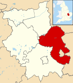 East Cambridgeshire shown within Cambridgeshire | |
| Sovereign state | United Kingdom |
| Constituent country | England |
| Region | East of England |
| Non-metropolitan county | Cambridgeshire |
| Status | Non-metropolitan district |
| Admin HQ | Ely |
| Incorporated | 1 April 1974 |
| Government | |
| • Type | Non-metropolitan district council |
| • Body | East Cambridgeshire District Council |
| • Leadership | Alternative - Sec. 31 (Conservative) |
| • MPs |
Stephen Barclay Lucy Frazer |
| Area[1] | |
| • Total | 251.5 sq mi (651.3 km2) |
| Area rank | 62nd (of 326) |
| Population (mid-2014 est.)[2] | |
| • Total | 86,685 |
| • Rank | 274th (of 326) |
| • Density | 340/sq mi (130/km2) |
| • Ethnicity |
95.9% White 1.0% S.Asian 1.1% Mixed 1.8% Chinese or Other |
| Time zone | GMT (UTC0) |
| • Summer (DST) | BST (UTC+1) |
| ONS code |
12UC (ONS) E07000009 (GSS) |
| OS grid reference | TL535799 |
| Website |
www |
East Cambridgeshire (locally known as East Cambs) is a local government district in Cambridgeshire, England. Its council is based in Ely. The population of the District Council at the 2011 Census was 83,818.[3]
The district was formed on 1 April 1974 with the merger of Ely Urban District, Ely Rural District and Newmarket Rural District.
According to a report by the Halifax bank in 2004, East Cambridgeshire has the fastest population growth rate of any British local authority other than the City of London.[4]
Archaeology
The recent Fenland survey of archaeological finds mentions an enumeration of findings made between 1884 and 1994 in the region to the north of Devil's Dyke and Cambridge, from the Stone Age, the Bronze Age and the Iron Age (the region south of Devil's Dyke is not yet included in the survey). By far the greatest quantities of bronze objects found in England were discovered in East Cambridgeshire.
The most important Bronze Age finds were discovered in Isleham (more than 6500 pieces), Stuntney, Soham, Wicken, Chippenham, Coveney, Mepal and Wilburton. These findings include swords, spear-heads, arrows, axes, palstaves, knives, daggers, rapiers, armour, decorative equipment (in particular for horses) and many fragments of sheet bronze. The greater part of these objects have been entrusted to the Moyse's Hall Museum in Bury St Edmunds while other items are in the University of Cambridge Museum of Archaeology and Anthropology in Cambridge. Other finds include traces of cremations and barrows, golden torques, an extensive ditch system and a wooden track-way between Fordey Farm (Barway) and Little Thetford.[5] Bronze razors have also been found and it is well known that Celts shaved their cheeks.[6]
Settlements in East Cambridgeshire
- Aldreth
- Ashley
- Barway
- Bottisham
- Brinkley
- Burwell
- Chettisham
- Cheveley
- Chippenham
- Coveney
- Dullingham
- Ely (City)
- Fordham
- Haddenham
- Isleham
- Little Downham
- Little Thetford
- Littleport
- Lode
- Longmeadow
- Mepal
- Prickwillow
- Pymoor
- Queen Adelaide
- Reach
- Soham (Town)
- Stetchworth
- Stretham
- Stuntney
- Sutton
- Swaffham Bulbeck
- Swaffham Prior
- Upware
- Wicken
- Wilburton
- Witcham
- Witchford
- Woodditton
See also
References
- ↑ "Standard Area Measurements - Local Authorities - Dec 2010 (SAM_LAD_DEC_2010_UK)". UK Standard Area Measurements (SAM). Office for National Statistics. 31 December 2010. Retrieved 1 October 2011.
- ↑ "Population estimates for UK mid-2014 analysis tool" (zip). Office for National Statistics. 25 June 2015. Retrieved 27 June 2015.
- ↑ "Non Metropolitan District population 2011". Neighbourhood Statistics. Office for National Statistics. Retrieved 13 July 2016.
- ↑ http://news.bbc.co.uk/1/hi/uk/4122731.stm news.bbc.co.uk
- ↑ Hall, David (1994). Fenland survey : an essay in landscape and persistence / David Hall and John Coles. London;English Heritage. pp. 81–88. ISBN 1-85074-477-7.
- ↑ Hall, David (1994). Fenland survey : an essay in landscape and persistence / David Hall and John Coles. London;English Heritage. p. 4. ISBN 1-85074-477-7.

| Unitary authorities | |
|---|---|
| Boroughs or districts | |
| Major settlements | |
| Rivers | |
| Topics |
|
Coordinates: 52°23′13″N 0°17′38″E / 52.387°N 0.294°E