East Berbice-Corentyne
| East Berbice-Corentyne Region 6 | |
|---|---|
| Administrative Region | |
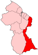 Map of Guyana showing East Berbice-Corentyne region | |
| Country | Guyana |
| Regional Capital | New Amsterdam |
| Area | |
| • Total | 36,234 km2 (13,990 sq mi) |
| Population (2012 census) | |
| • Total | 109,431 |
| • Density | 3.0/km2 (7.8/sq mi) |
| [1] | |
East Berbice-Corentyne (Region 6) is one of ten regions in Guyana covering the whole of the east of the country. It borders the Atlantic Ocean to the north, Suriname to the east, Brazil to the south and the regions of Mahaica-Berbice, Upper Demerara-Berbice, Potaro-Siparuni and Upper Takutu-Upper Essequibo to the west.
Towns in the region include New Amsterdam, Corriverton, Mara and Rose Hall.
The Corentyne River forms the whole of the eastern border with Suriname, though the southern-most section is disputed territory known as the New River Triangle.
Population
The Government of Guyana has administered three official censuses since the 1980 administrative reforms, in 1980, 1991 and 2002.[2] In 2012, the population of East Berbice-Corentyne was recorded at 109,431 people.[3] Official census records for the population of East Berbice-Corentyne are as follows:
- 2012 : 109,431
- 2002 : 123,695
- 1991 : 142,541
- 1980 : 152,386
Communities
(including name variants):
- Adventure
- Albion
- Alness (Alnes)
- Ankerville - Port Mourant
- Barakara (Barakara Mission)
- Belvedere
- Betsy Ground
- Bloomfield
- Brandwagt-Sari
- Bound Yard - Port Mourant
- Brighton
- Bush Lot (Bush Lot Village)
- Canefield
- Chesney
- Clifton Settlement - Port Mourant
- Corriverton
- Crabwood Creek
- Cumberland
- Dukestown
- East Canje
- Epira (Epira Mission, Espera)
- Eversham Village
- Friendship (Friendship Village, Corentyne)
- Free Yard - Port Mourant
- Fyrish (Fyrish Village)
- Gangaram
- Goldspie
- Goed Bananen Land
- Good Hope
- Haswell - Port Mourant
- Hogsty
- Islington
- Java
- Joanna
- Johns Settlement - Port Mourant
- Karaudanawa
- Kumaka
- Lancaster (lancaster Village)
- Leeds
- Letter Kenny
- Lesbeholden
- Limlair
- Macaw
- Manchester
- Mara
- Mibikuri
- Miss Phoebe North And South- Port Mourant
- Moleson Creek
- New Amsterdam
- New Forest
- New Ground Village
- New Hampshire
- Number Forty-Three
- Number Forty-five
- Number Forty-six
- Number Forty-seven
- Number Fort-Eight
- Number Fifty-nine
- Number Sixty
- Number Sixty-one
- Number Sixty-two
- Number Sixty-three
- Number Sixty-Four
- Number Sixty-six
- Number Sixty-seven
- Number Sixty-eight
- Number Sixty-nine
- Number Seventy
- Number 80
- Nurney
- Orealla (Oreala, Orealla Mission)
- Port Mourant (Port Mourant Village)
- Portuguese Quarters - Port Mourant
- Princetown
- Providence Place
- Reliance
- Rising (Rising Sun)
- Rose Hall
- Rose Hall Village
- Scottsburg
- Skeldon (Skeldon Place)
- Smythfield
- Springlands (Springlands Place)
- Stanleytown
- Tain Settlement - Port Mourant
- Tain Resource - Port Mourant
- Tarlogie (Tarlogie Farm)
- Train Line Dam - Port Mourant
- Ulverston
- Ward Village
- Wel te Vreeden
- West Canje
- Whim
- Yakusari
- Hackstyle
- Williamsburg
See also
References
- ↑ Macmillan Publishers (2009). "Administrative Regions - 5 and 6". Macmillan Junior Atlas: Guyana. Oxford: Macmillan Caribbean. p. 35. ISBN 9780333934173.
- ↑ Beaie, Sonkarley Tiatun (19 September 2007). "Chapter 3: National Redistribution and Internal Migration". 2002 Population and Housing Census - Guyana National Report. Bureau of Statistics. p. 51. Archived from the original (PDF) on 2 September 2012. Retrieved 29 August 2012.
- ↑ Beaie, Sonkarley Tiatun (19 September 2007). "National Population Trends: Size, Growth and Distribution" (PDF Download). 2002 Population and Housing Census - Guyana National Report. Bureau of Statistics. p. 25. Retrieved 29 August 2012.
Coordinates: 4°06′29″N 58°11′00″W / 4.107943°N 58.18337°W