East Barnet Urban District
| East Barnet East Barnet Valley (1863–1935) | |
|---|---|
| District | |
|
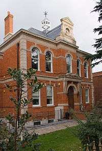
Town Hall | |
| Area | |
| • 1911 | 2,644 acres (10.70 km2)[1] |
| • 1961 | 2,644 acres (10.70 km2)[1] |
| Population | |
| • 1911 | 12,381[1] |
| • 1961 | 40,641[1] |
| History | |
| • Created | 1863 |
| • Abolished | 1965 |
| • Succeeded by | London Borough of Barnet |
| Status |
Local government district (1863–1875) Urban sanitary district (1875-1894) Urban district (1894–1965) |
| Government |
East Barnet Valley Local Board (1863–1875) |
| • HQ | Station Road, New Barnet |
| • Motto | Willingness rids way |
East Barnet Valley was a local government district from 1863 to 1965 around the town of East Barnet. It was partly in the counties of Hertfordshire and Middlesex until 1889, when the Middlesex part was transferred to Hertfordshire. It was renamed East Barnet in 1935.
Creation
The district was created under the Local Government Act 1858 on September 25, 1863, as East Barnet Valley Local Government District.[2] The district was governed by a local board. Apart from the parish of East Barnet, the local board's area included parts of the surrounding parishes of Chipping Barnet in Hertfordshire and Enfield, Monken Hadley and South Mimms in Middlesex.[3]
Reform
In 1889 the boundary between Hertfordshire and Middlesex was altered by the Local Government Act 1888, so that East Barnet Valley was entirely in the former county.
The Local Government Act 1894 reconstituted the local board's area as an urban district, governed by East Barnet Valley Urban District Council. The urban district consisted of three civil parishes, shown below with their area in 1901:
- East Barnet (1,697 acres)
- Barnet Vale (the area formerly in Chipping Barnet parish) (279 acres)
- Monken Hadley (the parts formerly in Middlesex) (668 acres)
The urban district was renamed East Barnet in 1935.[4]
The district formed part of a long, thin protrusion into Middlesex and was surrounded by that county on three sides; to the north, east and south.
Coat of arms
The urban district council adopted an unofficial coat of arms consisting of a shield bearing crossed swords between a red rose of Lancaster and a white rose of York and the Greek letter omega. This design represented the Battle of Barnet, the final battle in the Wars of the Roses. The chief or top third of the shield showed a fleur de lys between two flory crosses, emblems of St Mary, the patron saint of the ancient parish of East Barnet.[5] In 1955 this became the basis for an official grant from the College of Arms. A crest was added above the shield: a hart from the arms of Hertfordshire County Council, with a shield hanging from the neck bearing the cross of St Alban for the historical associations of the Abbey of St Albans with the area. The motto adopted: Willingness Rids Way, was from Shakespeare's Henry VI, Part 3. It comes from a speech made by Edward IV following the Battle of Barnet.[6]
Abolition
In 1965 the urban district was abolished by the London Government Act 1963 and its former area transferred from Hertfordshire to Greater London . Its former area was combined with that of other districts to form the present-day London Borough of Barnet.
Population
The area of the urban district was 2,644 acres (10.7 km2). The population, as returned at the census, was:
| Year | 1901 | 1911 | 1921 | 1931 | 1941 | 1951 | 1961 |
|---|---|---|---|---|---|---|---|
| Population | 10,094 | 12,381 | 13,514 | 18,549 | [7] | 40,408 | 40,641 |
Politics
The urban district was divided into seven wards for elections: Brunswick Park, Cockfosters, East Barnet, Hadley, Lyonsdown, New Barnet and Osidge.
Parliament constituency
For elections to Parliament, the urban district was part of the constituency of:
In 1945 St Albans was divided as an emergency measure because its electorate exceeded 100,000 voters, with the urban district becoming part of the new constituency of:
Gallery
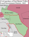
-

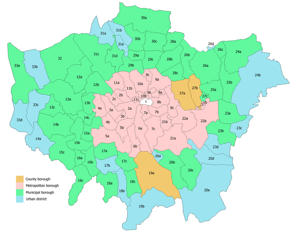
In 1961: 1 is Barnet and 2 is East Barnet
-
District in 1863.
-
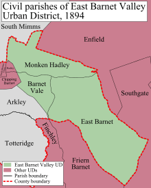
District in 1894.
-
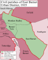
District in 1935.
References
- 1 2 3 4 Great Britain Historical GIS / University of Portsmouth, East Barnet UD population (area ). Retrieved on 2008-01-26.
- ↑ Kelly's Directory of Hertfordshire, 1899 , p.38 (Historical Directories)
- ↑ Frederic A Youngs Guide to the Local Administrative units of England, Volume I: Southern England, London 1979
- ↑ Great Britain Historical GIS / University of Portsmouth, East Barnet UD. Retrieved on 2008-01-26.
- ↑ C W Scott-Giles, Civic Heraldry of England and Wales, 2nd edition, London 1953
- ↑ Civic Heraldry of England and Wales: Hertfordshire (obsolete), accessed January 26, 2007
- ↑ The census was suspended for World War II
Local government districts abolished or transferred by the London Government Act 1963 | ||
|---|---|---|
| London | ||
| Essex | ||
| Hertfordshire | ||
| Middlesex, CC | ||
| Kent | ||
| Surrey | ||
| Transfers | Middlesex to Hertfordshire: Potters Bar
| |
Coordinates: 51°38′35″N 0°09′40″W / 51.643°N 0.161°W