ECEF
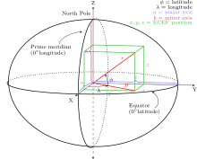
ECEF ("earth-centered, earth-fixed"), also known as ECR ("earth-centered rotational"), is a geographic coordinate system and Cartesian coordinate system, and is sometimes known as a "conventional terrestrial" system.[1] It represents positions as an X, Y, and Z coordinate. The point (0,0,0) is defined as the center of mass of the earth,[2] hence the name "earth-centered." Its axes are aligned with the international reference pole (IRP) and international reference meridian (IRM) that are fixed with respect to the surface of the earth,[3][4] hence the description "earth-fixed." This term can cause confusion since the earth does not rotate about the z-axis (unlike an inertial system such as ECI), and is therefore alternatively called ECR.
The z-axis extends through True north, which does not coincide with the instantaneous earth rotational axis.[3] The slight "wobbling" of the rotational axis is known as polar motion.[5] The x-axis intersects the sphere of the earth at 0° latitude (the equator) and 0° longitude (prime meridian in Greenwich). This means that ECEF rotates with the earth, and therefore coordinates of a point fixed on the surface of the earth do not change. Conversion from a WGS84 datum to ECEF can be used as an intermediate step in converting velocities to the north east down coordinate system.
See also
- Geodetic system
- Earth-centered inertial coordinate system
- International Terrestrial Reference System (ITRS)
- Orbital state vectors
References
- ↑ Alfred Leick, 2004, GPS Satellite Surveying, Wiley
- ↑ James R. Clynch (February 2006). "Earth Coordinates" (PDF). Archived from the original (PDF) on 18 April 2015.
- 1 2 http://www.weblab.dlr.de/rbrt/pdf/TN_0001.pdf
- ↑ http://metadata.dod.mil/mdr/ns/GSIP/crs/WGS84C_3D
- ↑ http://www.iers.org/nn_10398/IERS/EN/Science/EarthRotation/PolarMotion.html?__nnn=true
External links
- ECEF datum transformation Notes on converting ECEF coordinates to WGS-84 datum
- Datum Transformations of GPS Positions Application Note Clearer notes on converting ECEF coordinates to WGS-84 datum
- geodetic datum overview orientation of the coordinate system and additional information
- GeographicLib includes a utility CartConvert which converts between geodetic and geocentric (ECEF) or local Cartesian (ENU) coordinates. This provides accurate results for all inputs including points close to the center of the earth.
- EPSG:4978