Eagle River, Wisconsin
| Eagle River, Wisconsin | |
|---|---|
| City | |
|
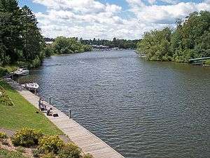
Downtown Eagle River | |
 Location of Eagle River, Wisconsin | |
| Coordinates: 45°55′12″N 89°15′1″W / 45.92000°N 89.25028°WCoordinates: 45°55′12″N 89°15′1″W / 45.92000°N 89.25028°W | |
| Country | United States |
| State | Wisconsin |
| County | Vilas |
| Area[1] | |
| • Total | 3.20 sq mi (8.29 km2) |
| • Land | 3.03 sq mi (7.85 km2) |
| • Water | 0.17 sq mi (0.44 km2) |
| Elevation[2] | 1,647 ft (502 m) |
| Population (2010)[3] | |
| • Total | 1,398 |
| • Estimate (2012[4]) | 1,373 |
| • Density | 461.4/sq mi (178.1/km2) |
| Time zone | Central (CST) (UTC-6) |
| • Summer (DST) | CDT (UTC-5) |
| Area code(s) | 715 & 534 |
| FIPS code | 55-21625[5] |
| GNIS feature ID | 1579167[2] |
| Website |
eagleriver |

Eagle River is a city in Vilas County, Wisconsin, United States. The population was 1,398 at the 2010 census. It is the county seat of Vilas County.[6] Because of the many lakes in the area, the city is a popular vacation and retirement destination. The area contains many condominia, seasonal vacation homes, and hunting cabins.
History
Origins
Eagle River was the site of the first permanent Indian settlement in the Wisconsin Northwoods, located on the shores of Watersmeet Lake where the Wisconsin River and Chain 0' Lakes meet. These early Indians, who were called Old Copper Indians, were succeeded by the Woodland Indians from 2,600 B.C. to 800 A.D. These Indians were probably the ancestors of the Chippewa, Potawatomi, and Menominee.[7]
Founding
The first recorded white settler in what became Vilas County was a man named Ashman who established a trading post in Lac du Flambeau in 1818.[8] Eagle River's name was derived from the abundance of eagles nesting along the river. It is believed that Bethuel Draper and "Dutch Pete" Cramer camped in the area in 1853 and were responsible for naming the community. A settlement grew as other families settled in the area in 1857. The town of Eagle River was created by an act of the state legislature in 1885. Vilas County was set off from Oneida County on April 12, 1893 and named for William Freeman Vilas, a migrant from Vermont. Vilas had served for Wisconsin in the United States Senate from 1891 to 1897.[9][10] In the 1850s migrants from New England, primarily from Vermont and Connecticut, constructed a number of wagon roads and trails through Vilas County including the Ontonogan Mail Trail and a Military Road from Fort Howard to Fort Wilkins in Copper Harbor, Michigan.[8]
Geography
Eagle River is located in southeastern Vilas County at 45°55′12″N 89°15′1″W / 45.92000°N 89.25028°W (45.919902, -89.250210),[11] along the Eagle River,[12] which is part of a popular chain of lakes. The Eagle River/Three Lakes Chain of Lakes is made up of 28 lakes, which is the largest number of inland interconnecting lakes in the world.
According to the United States Census Bureau, the city has a total area of 3.20 square miles (8.29 km2), of which, 3.03 square miles (7.85 km2) is land and 0.17 square miles (0.44 km2) is water.[1]
Climate
Eagle River has a cool humid continental climate (Köppen Dfb), with long, cold winters and short, mild summers. Annually the temperature drops below 32 °F (0 °C) on 190 days, and below 0 °F (-17.8 °C) on 39 days. The comfortable summers result in only one day per year on average with temperatures exceeding 90 °F (32.2 °C).
| Climate data for Eagle River, Wisconsin | |||||||||||||
|---|---|---|---|---|---|---|---|---|---|---|---|---|---|
| Month | Jan | Feb | Mar | Apr | May | Jun | Jul | Aug | Sep | Oct | Nov | Dec | Year |
| Record high °F (°C) | 42 (6) |
53 (12) |
71 (22) |
80 (27) |
86 (30) |
93 (34) |
97 (36) |
93 (34) |
90 (32) |
80 (27) |
69 (21) |
57 (14) |
97 (36) |
| Average high °F (°C) | 20.7 (−6.3) |
25.6 (−3.6) |
36.3 (2.4) |
50.5 (10.3) |
65.8 (18.8) |
74.7 (23.7) |
78.1 (25.6) |
75.1 (23.9) |
65.1 (18.4) |
52.5 (11.4) |
36.7 (2.6) |
24.6 (−4.1) |
50.48 (10.26) |
| Daily mean °F (°C) | 10.4 (−12) |
15.6 (−9.1) |
25.4 (−3.7) |
39.7 (4.3) |
53.2 (11.8) |
63.0 (17.2) |
66.6 (19.2) |
64.7 (18.2) |
54.5 (12.5) |
43.2 (6.2) |
29.0 (−1.7) |
16.3 (−8.7) |
40.13 (4.52) |
| Average low °F (°C) | 0.0 (−17.8) |
5.3 (−14.8) |
14.5 (−9.7) |
28.8 (−1.8) |
40.6 (4.8) |
51.2 (10.7) |
55.1 (12.8) |
54.2 (12.3) |
43.9 (6.6) |
33.9 (1.1) |
21.2 (−6) |
7.9 (−13.4) |
29.72 (−1.27) |
| Record low °F (°C) | −33 (−36) |
−36 (−38) |
−21 (−29) |
0 (−18) |
23 (−5) |
28 (−2) |
37 (3) |
39 (4) |
26 (−3) |
13 (−11) |
−9 (−23) |
−22 (−30) |
−36 (−38) |
| Average precipitation inches (mm) | 1.29 (32.8) |
0.80 (20.3) |
1.67 (42.4) |
2.10 (53.3) |
3.17 (80.5) |
3.52 (89.4) |
3.62 (91.9) |
3.92 (99.6) |
3.78 (96) |
2.41 (61.2) |
2.06 (52.3) |
1.25 (31.8) |
29.59 (751.6) |
| Average snowfall inches (cm) | 15.8 (40.1) |
8.6 (21.8) |
7.7 (19.6) |
2.2 (5.6) |
0.3 (0.8) |
0 (0) |
0 (0) |
0 (0) |
0 (0) |
0.6 (1.5) |
5.4 (13.7) |
12.1 (30.7) |
52.7 (133.9) |
| Source: Midwestern Regional Climate Center[13] | |||||||||||||
Demographics
| Historical population | |||
|---|---|---|---|
| Census | Pop. | %± | |
| 1890 | 1,150 | — | |
| 1910 | 1,141 | — | |
| 1920 | 672 | −41.1% | |
| 1930 | 1,386 | 106.3% | |
| 1940 | 1,491 | 7.6% | |
| 1950 | 1,469 | −1.5% | |
| 1960 | 1,367 | −6.9% | |
| 1970 | 1,326 | −3.0% | |
| 1980 | 1,326 | 0.0% | |
| 1990 | 1,374 | 3.6% | |
| 2000 | 1,443 | 5.0% | |
| 2010 | 1,398 | −3.1% | |
| Est. 2015 | 1,363 | [14] | −2.5% |
2010 census
As of the census[3] of 2010, there were 1,398 people, 684 households, and 308 families residing in the city. The population density was 461.4 inhabitants per square mile (178.1/km2). There were 876 housing units at an average density of 289.1 per square mile (111.6/km2). The racial makeup of the city was 93.0% White, 0.8% African American, 3.5% Native American, 0.1% Asian, 1.1% from other races, and 1.6% from two or more races. Hispanic or Latino of any race were 1.9% of the population.
There were 684 households of which 21.8% had children under the age of 18 living with them, 28.7% were married couples living together, 12.1% had a female householder with no husband present, 4.2% had a male householder with no wife present, and 55.0% were non-families. 46.5% of all households were made up of individuals and 22.5% had someone living alone who was 65 years of age or older. The average household size was 1.89 and the average family size was 2.68.
The median age in the city was 43.2 years. 18% of residents were under the age of 18; 9.4% were between the ages of 18 and 24; 25.2% were from 25 to 44; 24.5% were from 45 to 64; and 23% were 65 years of age or older. The gender makeup of the city was 49.1% male and 50.9% female.
2000 census
As of the census[5] of 2000, there were 1,443 people, 626 households, and 321 families residing in the city. The population density was 566.3 people per square mile (218.5/km²). There were 726 housing units at an average density of 284.9 per square mile (109.9/km²). The racial makeup of the city was 95.98% White, 1.39% African American, 1.94% Native American, 0.07% Pacific Islander, 0.35% from other races, and 0.28% from two or more races. Hispanic or Latino of any race were 0.83% of the population.
There were 626 households out of which 23.0% had children under the age of 18 living with them, 35.8% were married couples living together, 11.2% had a female householder with no husband present, and 48.7% were non-families. 43.6% of all households were made up of individuals and 24.6% had someone living alone who was 65 years of age or older. The average household size was 2.01 and the average family size was 2.80.
In the city the population was spread out with 19.4% under the age of 18, 8.2% from 18 to 24, 25.4% from 25 to 44, 20.6% from 45 to 64, and 26.5% who were 65 years of age or older. The median age was 42 years. For every 100 females there were 82.4 males. For every 100 females age 18 and over, there were 76.7 males.
The median income for a household in the city was $23,611, and the median income for a family was $36,339. Males had a median income of $29,375 versus $21,477 for females. The per capita income for the city was $15,876. About 8.6% of families and 11.8% of the population were below the poverty line, including 15.9% of those under age 18 and 11.7% of those age 65 or over.
Transportation
Highways
| | U.S. 45 travels northbound to Land o' Lakes. Southbound, US 45 routes to Three Lakes and Antigo. |
| | WIS 17 travels north concurrently with US 45 and WIS 32 approximately 4 miles (6.4 km) before splitting off northeasterly towards Phelps and west concurrently with WIS 70 before turning south towards Rhinelander, Wisconsin. |
| | WIS 32 runs concurrently with US 45 through Eagle River. |
| | WIS 70 travels east on a winding course through the Chequamegon-Nicolet National Forest to Florence and west via St. Germain to Woodruff and Minocqua. |
Airport

Eagle River is served by the Eagle River Union Airport (KEGV), which serves as a landing spot for seasonal home owners. Located just northwest of the city, the airport handles approximately 20,000 operations per year, with roughly 90% general aviation and 10% air taxi. The airport has a 5,000-ft asphalt runway with approved LOC/DME and GPS approaches (Runway 4-22), a 3,400-ft asphalt crosswind runway (Runway 13-31) and a helipad. [16]
Media
Sports and recreation

Common recreational activities include boating, camping, fishing, swimming, hunting, golfing, ice fishing, and snowmobiling. Bald eagles can be viewed here, the source of the name "Eagle" River.
Eagle River is known as the "Snowmobile Capital of the World" because of the World Championship Snowmobile Derby held for over 50 years at an ice oval on the north side of the city. There are over 500 miles of groomed snowmobile trails in the county. The World Snowmobile Headquarters and International Snowmobile Hall of Fame are located in Eagle River.
The Wisconsin Hockey Hall of Fame is in Eagle River Stadium in Eagle River. Eagle River has been the host of the Labatt Blue USA hockey pond hockey championship games.
Eagle River has a public golf course, located on East McKinley Street.
Notable people
- Jim Abrahams, director and screenwriter
- Charles Comiskey, former owner of the Chicago White Sox, member of the National Baseball Hall of Fame
- John A. Conant, lawyer and Wisconsin state legislator
- Claire Decker, racing car driver
- Natalie Decker, racing car driver
- Paige Decker, racing car driver
- Emil Gross, MLB player
- Craig Ludwig, NHL player and assistant coach
- Sean McKeever, comic book writer.
- Robert Peters, poet
- Daniel E. Riordan, teacher, lawyer and Wisconsin state legislator
- Margaret P. Varda, lawyer and Wisconsin state legislator[17]
- Cy Williams, MLB player.
- Jinelle Zaugg-Siergiej, Olympic athlete
Images
 Sign on U.S. Route 45
 Post office
 Water tower
 Eagle River Derby Track in summer
 Northland Pines High School
 Walter Olson Memorial Library
References
- 1 2 "US Gazetteer files 2010". United States Census Bureau. Retrieved 2012-11-18.
- 1 2 "US Board on Geographic Names". United States Geological Survey. 2007-10-25. Retrieved 2008-01-31.
- 1 2 "American FactFinder". United States Census Bureau. Retrieved 2012-11-18.
- ↑ "Population Estimates". United States Census Bureau. Retrieved 2013-06-24.
- 1 2 "American FactFinder". United States Census Bureau. Retrieved 2008-01-31.
- ↑ "Find a County". National Association of Counties. Retrieved 2011-06-07.
- ↑ http://www.eagleriver.org/history.asp
- 1 2 Vilas County, WI Government Main Page Accessed January 11, 2011
- ↑ Horace Samuel Merrill. William Freeman Vilas: Doctrinaire Democrat. Madison: State Historical Society of Wisconsin, 1954.
- ↑ Vilas County History.
- ↑ "US Gazetteer files: 2010, 2000, and 1990". United States Census Bureau. 2011-02-12. Retrieved 2011-04-23.
- ↑ Wisconsin Atlas & Gazetteer. Yarmouth, Me.: DeLorme. 1992. p. 98. ISBN 0-89933-247-1.
- ↑ "Climate of the Midwest: Climate Summaries". Midwestern Regional Climate Center. 2012. Retrieved on July 16, 2012.
- ↑ "Annual Estimates of the Resident Population for Incorporated Places: April 1, 2010 to July 1, 2015". Retrieved July 2, 2016.
- ↑ "Census of Population and Housing". Census.gov. Retrieved June 4, 2015.
- ↑ http://www.airnav.com/airports/egv
- ↑ 'Wisconsin Blue Book 1944,' Biographical sketch of Margaret P. Varda, pg. 49
External links
- City of Eagle River
- Eagle River Area Chamber of Commerce
- Sanborn fire insurance maps: 1894 1901 1909
Municipalities and communities of Vilas County, Wisconsin, United States | ||
|---|---|---|
| City | 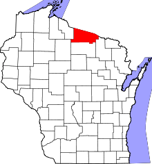 | |
| Towns | ||
| CDPs | ||
| Unincorporated communities | ||
| Indian reservations | ||
| Footnotes | ‡This populated place also has portions in an adjacent county or counties | |