NASA ERAST Program

The Environmental Research Aircraft and Sensor Technology, or ERAST program was a NASA program to develop cost-effective, slow-flying unmanned aerial vehicles (UAVs) that can perform long-duration science missions at altitudes above 60,000 feet. The project included a number of technology development programs conducted by the joint NASA-industry ERAST Alliance. The project was formally terminated in 2003.[1]
Program overview
According to NASA, "ERAST is a multiyear effort to develop the aeronautical and sensor technologies for a new family of remotely piloted aircraft intended for upper atmospheric science missions. Designed to cruise at slow speeds for long durations at altitudes of 60,000 to 100,000 ft, such aircraft could be used to collect, identify, and monitor environmental data to assess global climate change and assist in weather monitoring and forecasting. They also could serve as airborne telecommunications platforms, performing functions similar to communications satellites at a fraction of the cost of lofting a satellite into space."[2]
"The ERAST program is sponsored by the Office of Aeronautics and Space Transportation Technology at NASA Headquarters, and is managed by NASA Dryden Flight Research Center. The NASA Ames Research Center, Moffett Field, California, heads the sensor technology development. The NASA Lewis Research Center, Cleveland, Ohio, and NASA Langley Research Center, Hampton, Virginia, are contributing expertise in the areas of propulsion, structures, and systems analysis. Several small high-technology aeronautical development firms, including ALTUS developer General Atomics Aeronautical Systems, Inc., are teamed with NASA in the ERAST Alliance to work towards common goals of the program."[2] Industry partners in the ERAST Alliance included Aurora Flight Sciences, AeroVironment, General Atomics, Scaled Composites, Thermo-Mechanical Systems, Hyperspectral Sciences, and Longitude 122 West.[1]
The ERAST project was a model of public-private collaboration, later emulated by other NASA facilities and federal agencies. The partnership model was based on the innovative Joint Sponsored Research Agreement (JSRA), acknowledged by NASA officials as groundbreaking and by the ERAST participants as a key enabler of the technical success of the program. The JSRA, which bypasses the procurement system and constraints that inhibit collaboration and rapid progress, was designed by American Technology Alliances (AmTech). AmTech served as the ERAST partnership manager for the duration of the project.
The types of science mission ERAST prepares for can include remote sensing for Earth sciences studies, hyperspectral imaging for agriculture monitoring, tracking of severe storms, and serving as telecommunications relay platforms.[2]
A parallel effort headed by Ames developed lightweight, microminiaturized sensors that can be carried by these aircraft for environmental research and Earth monitoring.
Additional technologies considered by the ERAST Alliance include lightweight materials, avionics, aerodynamics, and other forms of propulsion suitable for extreme altitudes and duration.
Although ERAST Alliance members were responsible for aircraft development and operation, NASA had primary responsibility for overall program leadership, major funding, individual project management, development and coordination of payloads. NASA also worked on long-term issues with the Federal Aviation Administration and developed technology to make operation of these remotely operated aircraft in national airspace practical.
History
In 1987 and 1988, NASA conducted atmospheric ozone-layer depletion studies using two piloted NASA aircraft, a modified Douglas DC-8 jetliner and a Lockheed ER-2, a civilian version of the U-2 spy plane. However, operating the ER-2 over Antarctica, where ozone depletion took place, was regarded as risky, since if the pilot had to bail out, survival was unlikely. In addition, the ER-2 had a ceiling of 20 kilometers (65,000 feet), while ozone depletion takes place at 30 kilometers (100,000 feet), and the ER-2 could not stay aloft long enough to study ozone changes during a full day-night cycle.[1]
In 1988, NASA decided to obtain a HALE UAV named "Perseus" to deal with these problems, designating the effort the Small High-Altitude Science Aircraft (SHASA) program. Perseus was designed by a startup company named Aurora Flight Sciences of Manassas, Virginia. The Perseus design effort struggled along on skimpy funds until 1991, when NASA was conducting a "High Speed Research Program" to evaluate designs for a future supersonic transport, and needed to learn more about the possible environmental impact of such an aircraft on the upper atmosphere. Funds became available to procure a few aircraft.[1]
Other government agencies were also interested in HALE UAVs, and so the ERAST effort was born in September 1994 as a high-profile item in NASA'a agenda. ERAST was formally intended to promote the use of UAVs in commercial science applications, particularly high-altitude atmospheric research. ERAST also has focused on development of new miniaturized sensor and avionics systems for the UAVs and for NASA's Lockheed ER-2.[1]
Project components and programs
Aircraft
ALTUS

The General Atomics ALTUS II is a civilian variant of the MQ-1 Predator UAV designed for scientific research missions. One of the two ALTUS aircraft, ALTUS II, was built under the ERAST program and has participated in a number of the related research missions.[2]
The ALTUS II made its first flight on May 1, 1996. With its engine at first augmented by a single-stage turbocharger, the ALTUS II reached an altitude of 37,000 ft during its first series of development flights at Dryden in August, 1996. In October of that year, the ALTUS II was flown in an Atmospheric Radiation Measurement (ARM-UAV) study in Oklahoma conducted by Sandia National Laboratories for the Department of Energy. During the course of those flights, the ALTUS II set a single-flight endurance record for remotely operated aircraft of more than 26 hours. In October 1996, ALTUS II set an endurance record for UAVs carrying science payloads. The vehicle spent more than 24 hours at the required altitude during an ARM-UAV.
After major modifications and upgrades, including installation of a two-stage turbocharger in place of its original single-stage unit, a larger fuel tank and additional intercooling capacity, the ALTUS II returned to flight status in the summer of 1998. The goal of its development test flights was to reach one of the major ERAST Level 2 performance milestones, to fly a gasoline-fueled, piston-engine remotely piloted aircraft for several hours at an altitude at or near 60,000 feet. On March 5, 1999, The ALTUS II maintained flight at or above 55,000 feet for three hours, reaching a maximum density altitude of 57,300 feet during the mission.[3]
Pathfinder, Centurion, and Helios
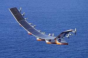
The NASA Pathfinder, Centurion, and Helios aircraft were a series of solar- and fuel cell system-powered UAVs, which AeroVironment, Inc. developed the vehicle under the ERAST program.[4]
Pathfinder, which was designed and built by AeroVironment, is essentially a flying wing with a 99-foot span. Solar photovoltaic cells mounted on the top of the wing produce up to 7,200 watts, powering the aircraft's six electric-driven propellers, as well as the suite of scientific instruments. Backup batteries store solar energy to power the aircraft at night.[5]
Sensors and instruments
ARTIS camera
A small Airborne Real-Time Imaging System (ARTIS) camera, developed by HyperSpectral Sciences, Inc., under ERAST project, was flight demonstrated during the summer of 1999 on board the Scaled Composites Proteus aircraft when it took visual and near-infrared photos from Proteus while it was flying high over the Experimental Aircraft Association's AirVenture 99 Airshow at Oshkosh, Wisconsin. The images were displayed on a computer monitor at the show only moments after they were taken.
DASI
The Digital Array Scanned Interferometer (DASI) was operated from the Pathfinder in the summer of 1997, acquiring imaging interferometric data of the Hawaiian Islands. The DASI, which originated at Washington University and was jointly developed with Ames Research Center, had to meet the stringent engineering and operating requirements of the Pathfinder with respect to remote operation, very light weight, and low volume, power and bandwidth.[6][7]
DSA
In March 2002, NASA Dryden, in cooperation with New Mexico State University's Technical Analysis and Applications Center (TAAC), the FAA and several other entities, conducted flight demonstrations of an active detect, see and avoid (DSA) system for potential application to UAVs at Las Cruces, New Mexico. The Scaled Composites Proteus aircraft was flown as a surrogate UAV controlled remotely from the ground, although safety pilots were aboard to handle takeoff and landing and any potential emergencies. Three other aircraft, ranging from general aviation aircraft to a NASA F/A-18, served as "cooperative" target aircraft with an operating transponder. In each of 18 different scenarios, a Goodrich Skywatch HP Traffic Advisory System (TAS) on the Proteus detected approaching air traffic on potential collision courses, including several scenarios with two aircraft approaching from different directions. The remote pilot then directed Proteus to turn, climb or descend as needed to avoid the potential threat.
In April 2003, a second series of flight demonstrations focusing on "non-cooperative" aircraft (those without operating transponders), was conducted in restricted airspace near Mojave, California., again using the Proteus as a surrogate UAV. Proteus was equipped with a small Amphitech OASys 35 GHz primary radar system to detect potential intruder aircraft on simulated collision courses. The radar data was telemetered directly to the ground station as well as via an Inmarsat satellite system installed on Proteus. A mix of seven intruder aircraft, ranging from a sailplane to a high-speed jet, flew 20 scenarios over a four-day period, one or two aircraft at a time. In each case, the radar picked up the intruding aircraft at ranges from 2.5 to 6.5 miles, depending on the intruder's radar signature. Proteus' remote pilot on the ground was able to direct Proteus to take evasive action if needed.
See also
- NASA Mini-Sniffer
- Airborne Science Program
- NASA Earth Science Enterprise (formerly "Mission to Planet Earth")
- Atmospheric satellite
References
This article contains material that originally came from the web article "Unmanned Aerial Vehicles" by Greg Goebel, which exists in the Public Domain.
- 1 2 3 4 5 "Goebel, Greg, "The NASA ERAST HALE UAV Program", ''Unmanned Aerial Vehicles'', chapter 15. Exists in the public domain". Vectorsite.net. Retrieved August 7, 2011.
- 1 2 3 4 "NASA Altus II fact sheet". NASA. Retrieved August 7, 2011.
- ↑ "NASA Altus I page". NASA. Retrieved August 7, 2011.
- ↑ "NASA Pathfinder fact sheet". NASA. Retrieved August 7, 2011.
- ↑ "NASA's Solar-Powered Aircraft Begins Science Missions In Hawaii". Science Daily. November 4, 1997. Retrieved September 5, 2008.
- ↑ ""The use of DASI in the ERAST/Pathfinder Science Project", NASA fact sheet". Geo.arc.nasa.gov. Retrieved August 7, 2011.
- ↑ "Highlights from the DASI Pathfinder Mission, NASA, October 1997, archived at archive.org". Web.archive.org. March 12, 2007. Archived from the original on March 12, 2007. Retrieved August 7, 2011.
External links
- Katzberg, Stephen J. (August 1996). "Performance Assessment of the Digital Array Scanned Interferometer Concept". NASA Technical Paper 3570. CiteSeerX 10.1.1.30.4304
 .
. - Hammer, Philip D, et al., "Surface Reflectance Mapping Using Interferometric Spectral Imagery from a Remotely Piloted Aircraft"
- Pathfinder mission page, no longer active at NASA, archived at archive.org
- Pathfinder/Helios