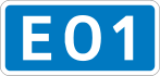
E01 expressway (Sri Lanka)
| |
|---|---|
| Colombo–Matara Expressway | |
 | |
| Route information | |
| Maintained by the Road Development Authority | |
| Length: | 133 km (83 mi) |
| Existed: | 27 November 2011 – present |
| History: |
Kottawa-Galle section Opened on 27 November 2011 Galle-Matara section Opened on 15 March 2014 |
| Major junctions | |
| North end: | Kottawa A4 - Start of E02 Colombo Outer Circular Expressway |
|
Exit 2 → B84 in Kahathuduwa - Start of E06 Ruwanpura Expressway | |
| South end: | Godagama A24 |
| Location | |
| Towns: | Panadura, Kalutara, Matugama, Bentota, Elpitiya, Ambalangoda, Galle, Matara |
| Highway system | |
| Expressways of Sri Lanka | |
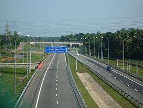
The Southern Expressway, also known as the Southern Lanka Distributor (Sinhala: දක්ෂිණ ලංකා අධිවේගි මාර්ගය Daksina Lanka Adhivegi Margaya), Tamil: தென்னிலங்கை அதிவேக நெடுஞ்சாலை) is Sri Lanka's first E Class highway. The 126 km (78 mi) long highway links the Sri Lankan capital Colombo with Galle and Matara, major cities in the south of the island.
The Southern Expressway Project- SEP- was introduced by the Road Development Authority and the Ministry of Highways as far back as late 1980s. the University of Moratuwa undertook the Environment Impact Assessment — EIA study in 1996 and the report was submitted in early 1997 and in 2002 began under the "regaining Sri Lanka" programme[1] [2][3]
Construction of the highway began in 2006 and completion up to Galle was done in November 2011. Later in March 2014, the section from Galle to Matara was declared open for the public. The construction of the expressway was partly funded by the Japan Bank for International Cooperation, who were responsible for the 65 km (40 mi) section between Kurundugahahetekma and Kokmaduwa and the Asian Development Bank for the 161 km (100 mi) section between Kurundugahahetekma and Pinnaduwa. The expressway currently reduces the time taken to travel from Colombo to Galle (116 km (72 mi)) to one hour from three hours and Colombo to Matara (29.3 km (18.2 mi)) to one and half hours from four hours taken by the regular A2 highway.
The extension of the expressway to Hambantota was inaugurated on 4 July 2015. The extension will be four lanes (with allowance of further two lanes in future), the cost of US $180M is being funded by the Exim Bank of China.[4]
On 10 August 2015, a Highway Traffic Management system was inaugurated and currently covers the length of the expressway, including the Outer-Circular Expressway.
Intersections
_in_Sri_Lanka.jpg)
| Location | km | Exit | Name | Destinations | Notes |
|---|---|---|---|---|---|
| 0.0 | 1 | Kottawa | A4 – Kottawa (1.8 km), Maharagama (6.3 km), Nugegoda (11.3 km), Colombo (20.6 km), Ratnapura (79.1 km), Avissawella (37 km), Homagama (2.2 km) | The start of the expressway; a continuation of the E02 Colombo Outer Circular Expressway | |
| 5.9 | 2 | Kahathuduwa | B084 – Kasbawa (5.8 km), Piliyandala (8.1 km), Colombo (25.7 km), Horana (12.3 km), Ingiriya (25.9 km), Ratnapura (63.5 km) | This intersection will be the beginning point of E06 Ruwanpura Expressway, Which will connect Rathnapura to the national expressway network.It will be opened in 2019. | |
| 13.7 | 3 | Gelanigama | A8 – Bandaragama (1.8 km), Panadura (11.6 km), Horana (6.9 km), Ingiriya (20.4 km), Ratnapura (58.1 km) | ||
| 34.8 | 4 | Dodangoda | B304 – Nagoda (11.5 km), Kalutara (17.0 km), Matugama (5.5 km), Kalawana (36.3 km) | ||
| 46.0 | 5 | Welipanna | B157 – Aluthgama (10.3 km), Matugama (11.5 km), Agalawatte (17.5 km) | ||
| 67.6 | 6 | Kurundugahahetekma | B014 – Elpitiya (3.8 km), Karandeniya (6.0 km), Batapola (7.0 km), Ambalangoda (13.2 km), Balapitiya (13.5 km) | ||
| 79.8 | 7 | Baddegama | B153 – Baddegama (1.5 km), Hikkaduwa (12.8 km), Nil Hena (2.4 km), Udugama (20.8 km) | ||
| 95.3 | 8 | Pinnaduwa | B594 – Galle (8.4 km) | Contains the 6-kilometre (3.7 mi) Galle Access road | |
| 108 | 9 | Imaduwa | A17 – Deniyaya, Ahangama, Dikkumbura, Akuressa, Suriyakanda, Rakwana, Madampe | ||
| 116.5 | 10 | Kokmaduwa | B465 – Weligama, Kananke | ||
| 127 | 11 | Godagama | A24 – Matara, Akuressa | The end of the expressway; there are proposals for it to be extended up to Hambantota | |
| 1.000 mi = 1.609 km; 1.000 km = 0.621 mi | |||||
Earnings and Traffic volumes
| Year since opening | Annual Earnings (Billion)Rs | Average Daily Earnings (USD) | Annual Traffic Volume(Million) | Average Daily Traffic volume | ROI on capital (Billion) Rs | Earning per KM (USD) |
|---|---|---|---|---|---|---|
| 2012 | 0.975 | $21,000 | 3.3[5] | 9000 | -125.25 | $80,500 |
| 2013 | - | - | ||||
| 2014 | - | - |
Toll structure
As of now the tolling process is done completely manually (i.e. with cash only). Yet an ETC (Electronic Toll Collection) System is proposed and in implementation process.[6]

See also
-
 Roads portal
 -
 Sri Lanka portal
References
- ↑ "opinio06". www.island.lk. Retrieved 2016-07-22.
- ↑ "Plus". www.sundaytimes.lk. Retrieved 2016-07-22.
- ↑ "REGAINING SRI LANKA:" (PDF).
- ↑ "Construction of Matara - Hambantota Expressway launched". Colombo Gazette. 22 August 2015.
- ↑ http://www.highbeam.com/doc/1P3-2824346191.html
- ↑ http://www.exway.rda.gov.lk/index.php?page=user_guide#paying_userfee