E-470
| ||||
|---|---|---|---|---|
|
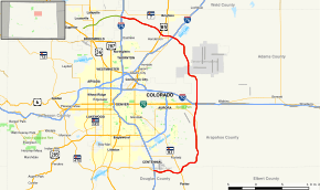
Map of north central Colorado with E-470 highlighted in red | ||||
| Route information | ||||
| Maintained by E-470 Public Highway Authority | ||||
| Length: | 46.950 mi[1] (75.559 km) | |||
| Existed: | 1991 – present | |||
| Major junctions | ||||
| South end: |
| |||
| North end: |
| |||
| Highway system | ||||
|
Colorado State Highways
| ||||

E-470 is a 47-mile-long (76 km) controlled-access toll road traversing the eastern portion of the Denver-Aurora Metropolitan Area in the US state of Colorado. The toll road is not a state highway, but is instead owned and maintained by the E-470 Public Highway Authority, which is controlled by a governing board of eight elected officials of eight local governments. Construction and operation involves no state or federal funding or taxes. As of 2014, 86% of its revenues were derived from tolls.
Route description
E-470 provides an alternate north–south route to Interstate 25 (I-25) for travelers wishing to bypass the eastern side of Metropolitan Denver area. The tollway begins at the I-25 / SH 470 interchange in Lone Tree and runs east and north through Aurora, passing east of Buckley Air Force Base before intersecting with I-70. The highway continues north, passing west of Denver International Airport to connect with I-76 in Brighton and Commerce City before curving west and ending at an interchange with I-25 and the Northwest Parkway in Thornton.
The 470 beltway
E-470 is the eastern portion of what was originally conceived as I-470, an outer beltway for metropolitan Denver.The quasi-government entity that manages the highway, the E-470 Public Highway Authority, consists of eight member jurisdictions: Adams, Arapahoe, and Douglas counties and the cities of Aurora, Brighton, Commerce City, Thornton, and the town of Parker. In addition to all of these jurisdictions, E-470 also passes through the City and County of Denver near Denver International Airport. Affiliate, non-voting members of the Authority, which the highway does not directly serve, are the cities of Arvada, Lone Tree and Greeley, and Weld County and the City and County of Broomfield. Ex-officio members are the Colorado Department of Transportation, the Denver Regional Council of Governments and the Regional Transportation District. The authority is headquartered in Aurora.
Tolls
The toll rate on E-470 for vehicles that do not have ExpressToll automated toll transponders, roughly 37 cents per mile (23 ¢/km), is one of the highest rates of any toll road in the United States.[2][3] In addition to 17 ramp toll interchanges, there are five mainline toll stations along the 47-mile (76 km) route and the average non-discounted toll to pass each mainline station is $3.49.[2] Traveling the entire length of the road from I-25 in the north to I-25 in the south (or vice versa) costs $14.00 for ExpressToll customers, and $17.45 for those without a transponder. Drivers with ExpressToll accounts, E-470's automated toll collection service, and transponders mounted on their vehicle save 20% on posted toll rates along E-470.[4]The toll stations no longer accept cash; E-470 was one of the first highways in the United States to implement full highway-speed electronic tolling.[5] Regarding License Plate Toll (for vehicles without ExpressToll transponders), cameras at each station photograph the front and rear license plate of each vehicle. A bill is mailed after approximately 30 days to the registered owner of the vehicle in accordance with state law.[6] The License Plate Toll statement must be paid in full by the due date or a second statement with a one-time $5 late fee will be mailed. If payment is still not received, a third statement is sent with no additional fees. If the account remains unpaid for more than 90 days, the account becomes delinquent and all overdue toll transactions will be sent to a collections law firm for up to four months in an attempt to find the customer and collect payment. The unpaid tolls, the $5 late fee, and a one-time $20 collection fee are due at this time. If payment is still not received, a Civil Penalty Assessment Notice will be mailed for the unpaid tolls, the $5 late fee, the $20 collection fee, and a $25 Civil Penalty per notice. Upon receipt of this document, the customer may request a hearing. If the full payment of the Civil Assessment Notice has not been received in 30 days, a Hearing Officer's Final Notice is issued to include the unpaid tolls, the $5 late fee, the $20 collection fee, the $25 Civil Penalty, and a $20 Court Fee, totaling a maximum of $70 of fees and penalties for each unpaid set of tolls.[7]
Rental car companies at Denver International Airport have been accused of over-charging unwitting visitors for unpaid tolls because of the road's cashless collection system.[8]
History
Plans for this eastern extension of State Highway 470 gained momentum in the 1980s, as Denver moved forward with plans for a new international airport in its corridor. Recognizing the highway's development potential, a number of local governments joined together to create the E-470 Public Highway Authority, a quasi-governmental entity that would construct the highway. In 1987, the Public Highway Authority Law was passed by the Colorado State Legislature, giving the E-470 Public Highway Authority the power to do everything needed to plan, design, finance, construct, and operate the toll highway.[9][10] The highway would be financed through tolls, a relative rarity in the western U.S.
The first section, between I-25 in the south and Parker Road in Douglas County, opened to traffic June 1, 1991. Tolling began on July 15, making E-470 the first highway in the United States to implement open road electronic tolling.[11] The highway was opened segment by segment until the final stretch connecting to I-25 in the north in Adams County opened on January 3, 2003.[12]

In its early years, traffic was light as the completed portion was short and traversed a largely undeveloped area. With the opening of Denver International Airport in 1995, E-470 came in as a direct route to the airport from the rapidly growing southern tier of the metropolitan area. Upon its completion, the highway provided the same access for northern Colorado, itself a high-growth area. However, perhaps the most significant growth in the region will occur in the E-470 corridor itself, which spawned numerous annexations by member cities; Commerce City, Colorado has doubled in land area in anticipation of this new development. In the coming decades, 250,000 new residents are expected along the E-470 corridor in Aurora alone, which would nearly double that city's population.
Up until 2006, E-470 had four signalized intersections with I-70 and its outer roads, which often got congested at peak hours. In 2006, the E-470 mainline was relocated about one-quarter mile to the west to bypass the traffic signals and provide free-flowing conditions for toll customers. Ramp traffic accessing I-70 continues to use the signalized interchange, except for northbound E-470 to westbound I-70 traffic, which uses a flyover ramp. The I-70/E-470 Fly-By Interchange Complex in Aurora was recognized by the Design Build Institute of America (DBIA) with a National Design Build Award in 2008.
In November 2014, an additional interchange opened at Quebec Street in Thornton.[13]
In April 2016, E-470 started construction work to widen an eight-mile stretch of the toll road to three lanes in each direction between Parker Road and Quincy Avenue in southeastern Aurora. The $90 million project is scheduled for completion in late 2017. According to the 2015 E-470 Annual Report (page 3), "The widening is being constructed now to get ahead of the curve on future traffic volume, which has had double-digit growth in each of the past three years."
Exit list
| County | Location | mi[1] | km | Exit | Destinations | Notes |
|---|---|---|---|---|---|---|
| Douglas | Lone Tree | 0.000 | 0.000 | 1A | Southern terminus of E-470; roadway continues as west SH 470; I-25 exit 194 | |
| Meridian | 1B | Jamaica Street to County Line Road | Westbound exit and eastbound entrance | |||
| 1.711 | 2.754 | 2 | ||||
| 2.700 | 4.345 | Toll Plaza A | ||||
| Stonegate | 3.502 | 5.636 | 3 | Chambers Road | ||
| Stonegate–Parker city line | 4.380 | 7.049 | 4 | Jordan Road – Parker | ||
| Parker | 5.180 | 8.336 | 5 | |||
| Arapahoe | Aurora | 8.887 | 14.302 | 9 | Gartrell Road | |
| 10.683 | 17.193 | 10 | Smoky Hill Road | |||
| 13.352 | 21.488 | 13 | Quincy Avenue – Aurora | |||
| 16.150 | 25.991 | Toll Plaza B | ||||
| 16.451 | 26.475 | 16 | Jewell Avenue to Iliff Avenue | |||
| 19.000 | 30.578 | 19 | 6th Parkway | |||
| Arapahoe–Adams county line | 20.375 | 32.790 | 20 | Northbound exits signed as 20A (east) and 20B (west), southbound exit 20, no toll either direction. I-70 exit 289. | ||
| Adams | 22.610 | 36.387 | Toll Plaza C | |||
| 24.477 | 39.392 | 24 | ||||
| 25.523 | 41.075 | 25 | 64th Avenue | |||
| City and County of Denver | 27.849 | 44.819 | 28 | Signed as exits 28A (east) and 28B (west); Peña Boulevard exit 6 | ||
| Adams | Commerce City | Toll Plaza D | ||||
| 30.562 | 49.185 | 31 | 96th Avenue | |||
| 32.678 | 52.590 | 32 | 104th Avenue | |||
| 34.130 | 54.927 | 34 | ||||
| Commerce City–Brighton city line | 35.491 | 57.117 | 35 | Northbound exit to eastbound I-76 and southbound entrance from westbound I-76, exit 18. | ||
| Brighton | 38.465 | 61.903 | 38 | |||
| Todd Creek | 40.220 | 64.728 | Toll Plaza E | |||
| Thornton | 41.710 | 67.126 | 41 | Quebec Street | Opened on November 24, 2014[13] | |
| 43.817 | 70.517 | 43 | Colorado Boulevard – Thornton | |||
| 44.843 | 72.168 | 45 | York Street | |||
| 46.398– 46.950 | 74.670– 75.559 | 47 | Northwest Parkway | Northern terminus of E-470; roadway continues west as Northwest Parkway; I-25 exit 228 | ||
1.000 mi = 1.609 km; 1.000 km = 0.621 mi
| ||||||
See also
 Colorado portal
 U.S. Roads portal
References
- 1 2 Colorado Department of Transportation. "Highway Data". Colorado Department of Transportation. Retrieved October 2007. Check date values in:
|access-date=(help) Note that not every interval between mileposts is exactly a mile, explaining why more exits than expected are at the exact milepost. - 1 2 E-470 Public Highway Authority (2011). "Calculating Tolls". E-470 Public Highway Authority. Retrieved January 9, 2012.
- ↑ Lewis, Al (January 1, 2006). "Toll Roads: Future Fodder for the Junk Bond Market; Roads Take Their Toll on Wallets". The Denver Post. Retrieved January 9, 2012.
- ↑ E-470 Public Highway Authority (2011). "ExpressToll". E-470 Public Highway Authority. Retrieved January 9, 2012.
- ↑ E-470 Public Highway Authority (2011). "How E-470 Works". E-470 Public Highway Authority. Retrieved January 9, 2012.
- ↑ Colorado General Assembly (2005). "Traffic Laws—Toll Collection". Colorado Revised Statutes. Colorado General Assembly. § 43-4-506.5 (6)(a). Retrieved June 29, 2016 – via LexisNexis.
- ↑ E-470 Public Highway Authority (2011). "Tolls". E-470 Public Highway Authority. Retrieved January 9, 2012.
- ↑ "Cashless E-470 Takes Toll on Rental-Car Drivers in the Form of Fines". The Denver Post. November 29, 2009. Retrieved August 5, 2013.
- ↑ E-470 Public Highway Authority (2011). "History". E-470 Public Highway Authority. Retrieved February 11, 2013.
- ↑ Colorado General Assembly (2005). "Public Highway Authority Law". Colorado Revised Statutes. Colorado General Assembly. §§ 43-4-501 et seq. Retrieved June 29, 2016 – via LexisNexis.
- ↑ Samuels, Peter (August 19, 2012). "Wikipedia Declares DNT and E470 Both 'First' in Electronic Tolling". TollRoadsNews. Retrieved August 20, 2012.
- ↑ E-470 Public Highway Authority. "E-470 Historical Fact File" (PDF). E-470 Public Highway Authority. Retrieved February 14, 2012.
- 1 2 Hendee, Caitlin (November 24, 2014). "E-470 Interchange in Thornton Opens". Denver Business Journal. Retrieved November 24, 2014.