Dyer Plateau
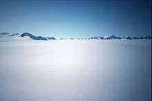
Dyer Plateau (70°30′S 65°0′W / 70.500°S 65.000°WCoordinates: 70°30′S 65°0′W / 70.500°S 65.000°W) is a broad ice-covered upland of north-central Palmer Land, bounded to the north by Fleming Glacier and Bingham Glacier, and to the south by the Gutenko Mountains. The plateau was first explored on land and photographed from the air by the US Antarctic Service (USAS), 1939–41. It was named after J. Glenn Dyer, a surveyor with the then General Land Office, Department of the Interior. He was leader of the USAS surface party which sledged from Fleming Glacier southeast across the plateau to the Welch Mountains, and U.S. observer with the Australian National Antarctic Research Expeditions during the 1956–57 season.[1]
References
- ↑ "Dyer Plateau". Geographic Names Information System. United States Geological Survey. Retrieved 2012-02-21.
![]() This article incorporates public domain material from the United States Geological Survey document "Dyer Plateau" (content from the Geographic Names Information System).
This article incorporates public domain material from the United States Geological Survey document "Dyer Plateau" (content from the Geographic Names Information System).