Dursey Island
| Native name: <span class="nickname" ">Oileán Baoi | |
|---|---|
|
Dursey Island as seen from a hiking path on the mainland | |
 Dursey Island | |
| Geography | |
| Location | Beara Peninsula |
| Coordinates | 51°36′N 10°12′W / 51.600°N 10.200°WCoordinates: 51°36′N 10°12′W / 51.600°N 10.200°W |
| Area | 5.6 km2 (2.2 sq mi) |
| Length | 6.5 km (4.04 mi) |
| Width | 1.5 km (0.93 mi) |
| Highest elevation | 252 m (827 ft) |
| Administration | |
|
Ireland | |
| Province | Munster |
| County | Cork |
| Demographics | |
| Population | 3 (2011) |
| Additional information | |
| Official website | DurseyIsland.ie |
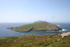
Dursey Island (Irish: Baoi Bhéarra or Oileán Baoi[1]) lies at the southwestern tip of the Beara Peninsula in the west of County Cork in Ireland. Dursey Island is 6.5 km long and 1.5 km wide. The island is separated from the mainland by a narrow stretch of water called Dursey Sound which has a very strong tidal race, with the submerged Flag Rock close to the centre of the channel. The island has just six or so permanent wintertime residents, and is connected to the mainland by Ireland's only cable car. Dursey has no shops, pubs or restaurants.[2] At one point there was a post office on the island, however this has since closed [1][3]
Geography and fauna
The townlands on the island are named Ballynacallagh, Kilmichael, and Tilickafinna. There are three main peaks on the island, the highest of which is 252m high.[4] The promontories and rocks off Dursey include:
Bull Rock
Off the western point of the island in a tidal race. Currently the site for an automated lighthouse which was built in 1888 and was automated in March 1991, the island was inhabited until this time.[5]
| Historical population | ||||||||||||||||||||||||||||||||||||||||||||||||||||||||||||||||||||||||||||||||
|---|---|---|---|---|---|---|---|---|---|---|---|---|---|---|---|---|---|---|---|---|---|---|---|---|---|---|---|---|---|---|---|---|---|---|---|---|---|---|---|---|---|---|---|---|---|---|---|---|---|---|---|---|---|---|---|---|---|---|---|---|---|---|---|---|---|---|---|---|---|---|---|---|---|---|---|---|---|---|---|---|
|
|
| ||||||||||||||||||||||||||||||||||||||||||||||||||||||||||||||||||||||||||||||
| Source: Central Statistics Office. "CNA17: Population by Off Shore Island, Sex and Year". CSO.ie. Retrieved October 12, 2016. | ||||||||||||||||||||||||||||||||||||||||||||||||||||||||||||||||||||||||||||||||
Calf Rock
Also off the western point of the island in a tidal race. Formerly the site of a manned lighthouse, it was destroyed in a storm in 1881 and the remains of the lighthouse can still be seen today.[6]
Cow Rock
Llies between the Bull Rock and the Calf Rock.
The island has a number of nesting colonies of seabirds, and dolphins, whales and basking sharks are sometimes seen in the seas surrounding the island.
History
A number of pre-historic sites have been surveyed on the island, including examples of Bullaun and Cup-marked stones in Ballynacallagh, a pre-historic hut site at Killowen, and a radial stone enclosure at Maughanaclea.[7]
More prominent archaeological sites are visible at Ballynacallagh where there is a ruined monastic church and graveyard, and the site of a castle on Oileán Beag ("Small Island"). In 1602 this castle site was a garrison of the O'Sullivan Beare family, and was destroyed (along with Dunboy Castle) during the Nine Years' War. Philip O'Sullivan Beare documents that the occupants of the castle were all killed - in what became known as the Dursey Massacre.[8] Very little evidence of the castle site remains.
On the highest point on the island, at Tilickatina, is a signal tower which dates to the Napoleonic Wars.[9] This narrow rectangular tower had two stories over a basement, with each story supported by vaulted stone work. The tower has been in ruin since the mid-19th century.[10]
During World War 2, a whitewashed sign (indicating "EIRE") was built close to the signal tower to indicate to pilots that they were overflying neutral Ireland. In July 1943 a Luftwaffe Junkers Ju 88 crashed on Crow Head near Dursey, killing all crew.[11]
| Historical population | |||||||||||||||||||||||||||||||||||||||||||||||||||||||||||||||||||||||||||||||||||
|---|---|---|---|---|---|---|---|---|---|---|---|---|---|---|---|---|---|---|---|---|---|---|---|---|---|---|---|---|---|---|---|---|---|---|---|---|---|---|---|---|---|---|---|---|---|---|---|---|---|---|---|---|---|---|---|---|---|---|---|---|---|---|---|---|---|---|---|---|---|---|---|---|---|---|---|---|---|---|---|---|---|---|---|
|
|
| |||||||||||||||||||||||||||||||||||||||||||||||||||||||||||||||||||||||||||||||||
| Source: Central Statistics Office. "CNA17: Population by Off Shore Island, Sex and Year". CSO.ie. Retrieved October 12, 2016. and "CD120: Population of Inhabited Islands Off the Coast by Sex, Islands by Electoral Division and CensusYear". | |||||||||||||||||||||||||||||||||||||||||||||||||||||||||||||||||||||||||||||||||||
Tourism

The island and cable-car are popular with day-trippers and walkers during the summer months. There is a waymarked section of the Beara Way which loops around the island.[12] Dursey Island's Beara Way walk marks the beginning of Europe's E8 Long Distance Walk, which traverses the continent of Europe, ending in Istanbul, Turkey.
Spanning Dursey Sound, the aerial tramway is Ireland's only cable car, and one of the only cable cars which traverse the sea in all of Europe. It is one of the island's main attractions.[13] Dursey Sound is also one of the "signature discovery points" along the Wild Atlantic Way[14] - a coastal touring route which stretches along Ireland's Atlantic coastline. Along one of these there is a 100 km/h speed limit sign - likely placed as a prank.[15]
Dursey has no shops, pubs or restaurants, but a small number of holiday homes can be rented on the island.[16]
Gallery
 Ecclesiastical ruins and graveyard at Ballynacallagh
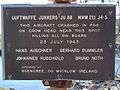 JU88 memorial sign on mainland next to Dursey cable car
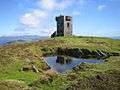 Napoleonic era signal tower
%2C_Standing_stone_-_geograph.org.uk_-_284000.jpg) Standing stones
Standing stones Remains of World War II "EIRE" neutrality sign
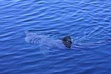 A basking shark feeds in the Dursey Sound.
| Wikimedia Commons has media related to Dursey Island. |
References
- 1 2 Logainm - Dursey
- ↑ "Dursey Island - Home". Durseyisland.ie. Retrieved 2014-07-28.
- ↑ West Cork and Kerry website
- ↑ Enright, Damien (2013-08-26). "Cork: Tracing Dursey Island's history". Irish Examiner. Retrieved 2014-07-28.
- ↑ "Lighthouses > Bull Rock". CommissionerOfIrishLights.com. Archived from the original on 1 January 2013.
- ↑
- ↑ Penelope Durell (1996). Discover Dursey. Ballinacarriga Books. p. 14.
- ↑ Timothy Daniel Sullivan (1908). Bantry, Berehaven and the O'Sullivan Sept. Sealy, Bryers & Walker. p. 20. Retrieved 2014-07-28.
- ↑ Samuel Lewis (1837). Topographical Dictionary of Ireland. Retrieved 2014-07-28.
- ↑ "The Signal Tower On Dursey Island". Mutantspace. Retrieved 2014-07-28.
- ↑ See memorial sign at cable-car crossing
- ↑ "Dursey Island Loop - Looped Walks". Discoverireland.ie. Retrieved 2014-07-28.
- ↑ "Cable Car Timetable - Dursey Island". Durseyisland.ie. 2014-06-14. Retrieved 2014-07-28.
- ↑ "Dursey Island - Wild Atlantic Way - Signature Point - Discover Ireland". Discoverireland.ie. Retrieved 23 August 2014.
- ↑ Flickr Mozzercork
- ↑ "Dursey Island Tourism Information". Discoverireland.ie. Retrieved 2014-07-28.