Dunfanaghy
| Dunfanaghy Dún Fionnachaidh | |
|---|---|
| Village | |
|
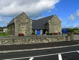
Main Street, Dunfanaghy | |
 Dunfanaghy Location in Ireland | |
| Coordinates: 55°10′59″N 7°58′16″W / 55.183°N 7.971°WCoordinates: 55°10′59″N 7°58′16″W / 55.183°N 7.971°W | |
| Country | Ireland |
| Province | Ulster |
| County | County Donegal |
| Elevation | 15 m (49 ft) |
| Population (2011)[1] | |
| • Total | 312 |
| Time zone | WET (UTC0) |
| • Summer (DST) | IST (WEST) (UTC-1) |
| Irish Grid Reference | C015372 |
_-_geograph.org.uk_-_1182764.jpg)
Dunfanaghy (Irish: Dún Fionnachaidh, meaning "fort of the fair field") is a small town, former fishing port, and commercial centre in County Donegal, Ireland. It lies on Donegal's North West coast, specifically the west side of Sheephaven Bay, on the N56 road (the West Donegal Coastal Route).
Before the Plantation, Dunfanaghy was part of the territory of the McGinley clan (Irish: Mag Fhionnghaile), a clan of the Cineál Luidhdheach, a branch of the greater Cineál Chonaill. The McGinley clan held their territory here under the guardianship of the powerful McSweeney clan.[2]
Description
The centre of Dunfanaghy is a small square with a market house built in 1847 and a quay built in 1831 and formerly used to export corn. There are four churches: Clondehorky Old Church (now ruined), Dunfanaghy Presbyterian Church, Holy Cross (Roman Catholic) and Holy Trinity Church of Ireland. The village is also home to a golf club, several art galleries and craft shops, and a museum, situated in part of a former workhouse, which describes the effects of the Irish Potato Famine on Dunfanaghy. Dunfanaghy is also home to C.L.G. Naomh Mícheál, a Gaelic football club.

Local area
Just outside the village is a three-mile-long sandy beach known as Killahoey Strand. On 16 June 1942, a Royal Air Force, Ferry Command aircraft landed on a beach near Dunfanaghy, Irish Army archive reports call this 'Hill Strand'. The aircraft was refuelled and the crew of four accommodated nearby overnight. They departed the next day to continue their delivery flight of the aircraft. This event became confused with another aircraft landing in 1943 when, in the early 1990s, an American veteran Harry X Ford made an effort to find the town in which he crashed landed on 10 May 1943. Having visited the town in 1993 it was finally discovered he had not actually landed there but had been on a B-17 Flying Fortress which force landed on a beach at Bundoran on 10 May 1943. Irish Army Archive reports confirm Harry X Ford's presence in Bundoran and not anywhere near Dunfanaghy or Portnablagh. Some sources published around 1993 attribute a landing on 2 May 1943 to have taken place on Killahoey Strand but this is an error confirmed by Irish Army Archives and the archives of the United States Air Force.

West of Dunfanaghy are New Lake and Tramore Strand, a two-mile-long beach. New Lake was formerly a salt water marsh, but during the First World War, over-cutting of the grass on the surrounding sand dunes led to their destabilisation and the movement of the sand to block up the river. As a result, the marsh filled with fresh water and became a lake. The sand also silted up Dunfanaghy harbour. The New Lake became a haven for seabirds and is now a Special Protection Area. Also nearby is Sessiagh Lough, a small lough with a crannog in the middle.
Across the bay from Dunfanaghy is Horn Head, which shelters Dunfanaghy from the Atlantic Ocean and is an Irish Natural Heritage Area. Dunfanaghy is close to Portnablagh and Marble Hill, both of which also have popular beaches. Other sights in the vicinity include: Ards Forest Park, Ards (Capuchin) Friary, Glenveagh National Park, Doe Castle and the Derryveagh Mountains, the most prominent being Muckish Mountain and Mount Errigal.
Workhouse
As in many parts of Ireland in the mid nineteenth century, a Workhouse was constructed nearby for the detention and maintenance of destitute local people. The first occupants were admitted in June 1845,[3] at the beginning of the Great Famine. Parts of the original building have recently been restored and now function as an interpretive centre of the Famine and its impact on the local inhabitants.
Near the workhouse, on the Falcarragh road, is the former Union fever hospital. Closed in 1922, it was reopened as a national school in the 1930s and fulfilled this role until the 1960s. Since 1968 it has been used as an artists studio and gallery.[4]
Transport
Dunfanaghy Road was previously a stop on the Londonderry and Lough Swilly Railway although the station was in fact six miles from Dunfanaghy itself. Dunfanaghy Road railway station opened on 9 March 1903, closed for passenger traffic on 3 June 1940 and finally closed altogether on 6 January 1947.[5] Lough Swilly Buses still serve the area with four buses per day going from Dunfanaghy to Letterkenny and vice versa. Lough Swilly Buses also provide school transport to primary schools and the main secondary schools Saint Eunan's College and Loreto Convent Secondary School, Letterkenny during school terms. John McGinley Coach Travel serve Dunfanaghy with a stop on the Annagary to Letterkenny route to Dublin.
Notable people
- Moya Cannon, author
- Gerry Robinson, businessman
See also
References
- ↑ "Census 2006 – Volume 1 – Population Classified by Area" (PDF). Central Statistics Office Census 2006 Reports. Central Statistics Office Ireland. April 2007. Retrieved 25 June 2011.
- ↑ Proinsias Mag Fhionnghaile, McGinley clan historian.
- ↑ Dudley Edwards, Robert (1976). Robert Dudley Edwards &Thomas Desmond Williams, ed. The great famine: studies in Irish history, 1845–52. Russell & Russell. p. 311. ISBN 978-0-8462-1793-0.
- ↑ "The Gallery". discoverireland.ie. 2009. Retrieved 30 April 2010.
- ↑ "Dunfanaghy Road station" (PDF). Railscot – Irish Railways. Retrieved 12 October 2007.
- Alistair Rowan (1979). The Buildings of Ireland: North West Ulster. Yale University Press. ISBN 0-300-09667-4.
- USAAF Crash report Crash file 43-5-18-501, Air Force Historical Support Office
- Irish Military Archives files, Files G2/X/1174 & ACF-S-166 (1943) and MA Files G2-X/1016 (1942)
External links
Places in County Donegal | ||
|---|---|---|
| Towns |  | |
| Villages |
| |
| Townlands | ||
| Islands | ||
| Other regions | ||
| ||