Dudley, Massachusetts
| Dudley, Massachusetts | ||
|---|---|---|
| Town | ||
|
War Monument by renowned sculptor John A. Wilson, Dudley, Massachusetts | ||
| ||
| Motto: All was others: All will be others | ||
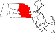
 Location in Worcester County and the state of Massachusetts. | ||
| Coordinates: 42°02′42″N 71°55′50″W / 42.04500°N 71.93056°WCoordinates: 42°02′42″N 71°55′50″W / 42.04500°N 71.93056°W | ||
| Country | United States | |
| State | Massachusetts | |
| County | Worcester | |
| Settled | 1714 | |
| Incorporated | 1732 | |
| Government | ||
| • Type | Open town meeting | |
| • Board of Selectmen | Chairman, Jonathan Ruda, Steven Sullivan, Peter Fox, Paul Joseph, John Marsi | |
| Area | ||
| • Total | 22.1 sq mi (57.1 km2) | |
| • Land | 21.1 sq mi (54.5 km2) | |
| • Water | 1.0 sq mi (2.6 km2) | |
| Elevation | 670 ft (204 m) | |
| Population (2010) | ||
| • Total | 11,390 | |
| • Density | 520/sq mi (200/km2) | |
| Time zone | Eastern (UTC-5) | |
| • Summer (DST) | Eastern (UTC-4) | |
| ZIP code | 01571 | |
| Area code(s) | 508/774 | |
| FIPS code | 25-17685 | |
| GNIS feature ID | 0618361 | |
| Website | www.dudleyma.gov | |


Dudley is a town in Worcester County, Massachusetts, United States. The population was 11,390 at the 2010 census.
History
Dudley was first settled in 1714 and was officially incorporated in 1732. The town was named for landholders Paul and William Dudley.[1]
In April 1776, on his way to New York City from Boston after his victory in the Siege of Boston, General George Washington camped in the town of Dudley with the Continental Army along what is now a portion of Route 31 near the Connecticut border. During the trip, it is rumored that a "large cache" of captured and recovered British weaponry and supplies was ordered "concealed in the grounds" in the rural area along the route. The cache, hidden to resupply reinforcements from Massachusetts or to cover a retreat from the south, were never used or recorded as having been recovered.[2]
Union soldiers from Dudley, the 15th Regiment Massachusetts Volunteer Infantry, suffered heavy casualties inflicted by the Confederacy during the Battle of Gettysburg.[3] Dudley was the primary manufacturer of "Brogan boots" worn by the Union Army and produced the majority of the standard issue Union uniforms worn during the Civil War.[4]
Cemetery Controversy
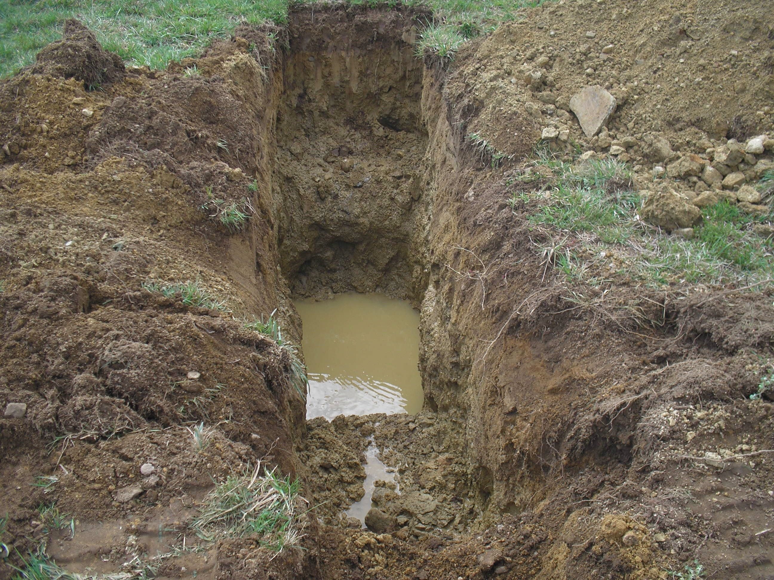
A proposal to create an Islamic cemetery that follows Islamic burial practices on 55 acres (22 ha) of farmland elicited intense community opposition when discussed at a public hearing in February 2016. Those that spoke made it clear that they don't want such a cemetery in their town with alleged concerns that included noise, traffic and well water contamination issues.[5] During a series of test pits that were dug by the applicant, with the Dudley Board of Health Inspector present, it was discovered that the average water table was 24" below the grade of the ground, with many spots having ground water only 18" from the surface. During the public hearing process for the Zoning Board of Appeals, it was discovered that the parcel of land where the proposed cemetery would be built was actually an agricultural protected parcel of land protected under MGL Chapter 61A.[6] In accordance with Mass Law, the parcel of land was supposed to be offered to the town first if the use was being changed away from agricultural. At a town meeting held on May 23, 2016, the town residents in an almost unanimous vote, authorized the Board of Selectman to exercise the Town's first right of refusal and proceed to purchase the agricultural piece of land. When the Zoning Board of Appeals met on June 2, 2016 they asked the Islamic Society of Worcester if they were presenting a revised 5 Acre cemetery plan which they had read about in the newspapers the week before. [7] The Islamic Society of Worcester stated there was no revised plan and they expected the Zoning Board of Appeals to vote on their original proposal for 12,000+ grave sites. The Zoning Board of Appeals then scheduled a full vote for June 9, 2016 at which time the application for a cemetery was denied because the Islamic Society of Worcester technically did not have a legal right to even submit the cemetery plan because they lacked the proper legal standing to do so. [8] The Islamic Society of Worcester asked for 3 continuances from the Town of Dudley Board of Health during its Public hearing process and failed to provide the Board of health with responses to 13 questions the Board of Health had sent in writing to the applicant on numerous occasions. The Islamic Society of Greater Worcester is working to establish a closer burial place as they currently travel to Enfield, Connecticut.[9]
Geography
According to the United States Census Bureau, the town has a total area of 22.1 square miles (57 km2), of which 21.0 square miles (54 km2) is land and 1.0 square mile (2.6 km2), or 4.58%, is water. Dudley is bounded on the northeast by Oxford, on the north by Charlton, on the west by Southbridge, on the south by Woodstock and Thompson, Connecticut, and on the east by Webster, with which it traditionally had the closest cultural and political relations.
Demographics
| Historical population | ||
|---|---|---|
| Year | Pop. | ±% |
| 1850 | 1,443 | — |
| 1860 | 1,736 | +20.3% |
| 1870 | 2,388 | +37.6% |
| 1880 | 2,803 | +17.4% |
| 1890 | 2,944 | +5.0% |
| 1900 | 3,553 | +20.7% |
| 1910 | 4,267 | +20.1% |
| 1920 | 3,701 | −13.3% |
| 1930 | 4,265 | +15.2% |
| 1940 | 4,616 | +8.2% |
| 1950 | 5,261 | +14.0% |
| 1960 | 6,510 | +23.7% |
| 1970 | 8,087 | +24.2% |
| 1980 | 8,717 | +7.8% |
| 1990 | 9,540 | +9.4% |
| 2000 | 10,036 | +5.2% |
| 2010 | 11,390 | +13.5% |
| * = population estimate. Source: United States Census records and Population Estimates Program data.[10][11][12][13][14][15][16][17][18][19] | ||
As of the census[20] of 2000, there were 10,036 people, 3,737 households, and 2,668 families residing in the town. The population density was 476.7 inhabitants per square mile (184.1/km2). There were 3,910 housing units at an average density of 185.7 per square mile (71.7/km2). The racial makeup of the town was 96.83% White, 0.23%African American, 0.23% Native American, 0.74% Asian, 0.75% from other races, and 0.97% from two or more races. Hispanic or Latino of any race were 2.01% of the population.
There were 3,737 households out of which 34.5% had children under the age of 18 living with them, 57.5% were married couples living together, 10.5% had a female householder with no husband present, and 28.6% were non-families. 23.5% of all households were made up of individuals and 10.5% had someone living alone who was 65 years of age or older. The average household size was 2.57 and the average family size was 3.04.
In the town the population was spread out with 24.7% under the age of 18, 10.6% from 18 to 24, 29.9% from 25 to 44, 22.0% from 45 to 64, and 12.8% who were 65 years of age or older. The median age was 36 years. For every 100 females there were 98.2 males. For every 100 females age 18 and over, there were 96.0 males.
The median income for a household in the town was $48,602, and the median income for a family was $59,309. Males had a median income of $40,337 versus $27,589 for females. The per capita income for the town was $21,546. About 3.1% of families and 5.6% of the population were below the poverty line, including 4.2% of those under age 18 and 10.1% of those age 65 or over.
Government
| County-level state agency heads | |
|---|---|
| Clerk of Courts: | Dennis P. McManus (D) |
| District Attorney: | Joseph D. Early, Jr. (D) |
| Register of Deeds: | Anthony J. Vigliotti (D) |
| Register of Probate: | Stephanie K. Fattman (R) |
| County Sheriff: | Lew Evangelidis (R) |
| State government | |
| State Representative(s): | Peter Durant (R) |
| State Senator(s): | Ryan Fattman (R) |
| Governor's Councilor(s): | Jen Caissie (R) |
| Federal government | |
| U.S. Representative(s): | Richard E. Neal (D-1st District) |
| U.S. Senators: | Elizabeth Warren (D), Ed Markey (D) |
Library
The public library in Dudley opened in 1897.[21][22] The library has changed location a few times since then, and in the early 21st century, a new building was constructed over the site of the former town hall, which had also been relocated. In fiscal year 2008, the town of Dudley spent 1.44% ($163,468) of its budget on its public library—some $14 per person.[23]
Education
Dudley is the home of Nichols College, which maintains a campus on Dudley Hill, the historical center of the town. Public schools in Dudley include Mason Road School (grades Preschool-1), Dudley Elementary School (grades 2-4), Dudley Middle School (grades 5-8) and Shepherd Hill Regional High School (grades 9-12), the last of which also serves students from Charlton. All public schools in Dudley are part of the Dudley-Charlton Regional School District. Dudley is one of ten towns whose students have the option of attending Bay Path Regional Vocational Technical High School (grades 9-12).[24]
Notable people
- James Blood, Civil War officer and husband of first female Presidential nominee
- Jacob P. Chamberlain, former US Congressman
- The Hotelier, Emo band
- Leo Martello, Wiccan priest and civil rights activist
References
- ↑ "Profile for Dudley, Massachusetts". ePodunk. Retrieved 2006-05-18.
- ↑ "George Washington Papers at the Library of Congress, 1741-1799: Series 3a Varick Transcript". The Library of Congress. Retrieved 2010-05-18.
- ↑ "Battle of Gettysburg". militaryhistoryonline.com. Retrieved 2007-06-03.
- ↑ "Stevens Linen". stevenslinen.com. Retrieved 2007-06-03.
- ↑ Ring, Kim (February 13, 2016). "Local Muslims address opposition on Dudley cemetery bid". telegram.com. Worcester, Massachusetts: Telegram & Gazette. Retrieved 17 February 2016.
- ↑ "General Laws: CHAPTER 61A". malegislature.gov. Retrieved 2016-06-16.
- ↑ "Islamic Society agrees to smaller cemetery in Dudley". telegram.com. Retrieved 2016-06-16.
- ↑ "Dudley zoning board rejects Muslim cemetery application". telegram.com. Retrieved 2016-06-16.
- ↑ Boeri, David (February 5, 2016). "Proposal For Muslim Cemetery In Dudley Meets Opposition From Residents". WBUR. Retrieved 15 February 2016.
- ↑ "TOTAL POPULATION (P1), 2010 Census Summary File 1". American FactFinder, All County Subdivisions within Massachusetts. United States Census Bureau. 2010.
- ↑ "Massachusetts by Place and County Subdivision - GCT-T1. Population Estimates". United States Census Bureau. Retrieved July 12, 2011.
- ↑ "1990 Census of Population, General Population Characteristics: Massachusetts" (PDF). US Census Bureau. December 1990. Table 76: General Characteristics of Persons, Households, and Families: 1990. 1990 CP-1-23. Retrieved July 12, 2011.
- ↑ "1980 Census of the Population, Number of Inhabitants: Massachusetts" (PDF). US Census Bureau. December 1981. Table 4. Populations of County Subdivisions: 1960 to 1980. PC80-1-A23. Retrieved July 12, 2011.
- ↑ "1950 Census of Population" (PDF). Bureau of the Census. 1952. Section 6, Pages 21-10 and 21-11, Massachusetts Table 6. Population of Counties by Minor Civil Divisions: 1930 to 1950. Retrieved July 12, 2011.
- ↑ "1920 Census of Population" (PDF). Bureau of the Census. Number of Inhabitants, by Counties and Minor Civil Divisions. Pages 21-5 through 21-7. Massachusetts Table 2. Population of Counties by Minor Civil Divisions: 1920, 1910, and 1920. Retrieved July 12, 2011.
- ↑ "1890 Census of the Population" (PDF). Department of the Interior, Census Office. Pages 179 through 182. Massachusetts Table 5. Population of States and Territories by Minor Civil Divisions: 1880 and 1890. Retrieved July 12, 2011.
- ↑ "1870 Census of the Population" (PDF). Department of the Interior, Census Office. 1872. Pages 217 through 220. Table IX. Population of Minor Civil Divisions, &c. Massachusetts. Retrieved July 12, 2011.
- ↑ "1860 Census" (PDF). Department of the Interior, Census Office. 1864. Pages 220 through 226. State of Massachusetts Table No. 3. Populations of Cities, Towns, &c. Retrieved July 12, 2011.
- ↑ "1850 Census" (PDF). Department of the Interior, Census Office. 1854. Pages 338 through 393. Populations of Cities, Towns, &c. Retrieved July 12, 2011.
- ↑ "American FactFinder". United States Census Bureau. Retrieved 2008-01-31.
- ↑ Report of the Free Public Library Commission of Massachusetts. v.9 (1899)
- ↑ Pearle L. Crawford Memorial Library Retrieved 2010-11-10
- ↑ July 1, 2007 through June 30, 2008; cf. The FY2008 Municipal Pie: What's Your Share? Commonwealth of Massachusetts, Board of Library Commissioners. Boston: 2009. Available: Municipal Pie Reports. Retrieved 2010-08-04
- ↑ "Bay Path Regional Vocational Technical High School - District Information". baypath.tec.ma.us. Retrieved 2015-10-09.
External links
| Wikimedia Commons has media related to Dudley, Massachusetts. |