Dooars
The Dooars or Duars (Pron: ˌdu:ˈɑ:z) (Bengali: ডুয়ার্স) are the floodplains and foothills of the eastern Himalayas in North-East India around Bhutan. Duar means 'door' in Assamese, Bengali, Nepali, Maithili, Bhojpuri, Magahi and Telugu languages, and the region forms the gateway to Bhutan from India.[1] There are 18 passages or gateways through which the Bhutanese people can communicate with the people living in the plains. This region is divided by the Sankosh river into the Eastern and the Western Dooars, consisting of an area of 8,800 km² (3,400 sq mi). The Western Dooars is known as the Bengal Dooars and the Eastern Dooars as the Assam Dooars. Dooars is synonymous with the term Terai used in Nepal and northern India
History
The Dooars belonged to the Kamata Kingdom under the Koch dynasty; and taking advantage of the weakness of the Koch kingdom in subsequent times, Bhutan took possession of the Dooars. This region was controlled by the kingdom of Bhutan when the British annexed it in 1865 after the Bhutan War under the command of Captain Hedayat Ali. The area was divided into two parts: the eastern part was merged with Goalpara district in Assam and the western part was turned into a new district named Western Dooars. Again in the year 1869, the name was changed to Jalpaiguri District. After the end of the British rule in India in 1947, the Dooars acceded into the dominion of India and it merged with the Union of India shortly afterwards in 1949.
Geography and climate
Political geography
The Dooars region politically constitutes the plains of Darjeeling District, the whole of Jalpaiguri district and Alipurduar district and the upper region of Cooch Behar district in West Bengal and the districts of Dhubri, Kokrajhar, Barpeta, Goalpara and Bongaigaon in the state of Assam.
Physical geography
The altitude of Dooars area ranges from 90 to 1,750 m. Innumerable streams and rivers flow through these fertile plains from the mountains of Bhutan. In Assam, the major rivers are the Brahmaputra and Manas. In northern West Bengal, the major river is the Teesta besides many others like the Jaldhaka, Murti, Torsha, Sankosh, Dyna, Karatoya, Raidak, and Kaljani rivers, among others.
Climate
The average rainfall of the area is about 3,500 mm. Monsoon generally starts from the middle of May and continues till the end of September. Winters are cold with foggy mornings and nights. Summer is mild and constitutes a very short period of the year.
People
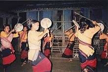
The native people of this region generally have Mongoloid features. They are composed of numerous tribes, including the Bodo in Assam, and the Rabha, the Mech, the Toto, the Koch Rajbongshi, the Tamang/Murmi, the Limbu, the Lepcha in Bengal. Most of the people found here are Nepali community .
Apart from the tribal population, a large Bengali population (mostly displaced from the then East Pakistan (now Bangladesh) by the Partition of Bengal) also populate the Dooars and their culture emerged with local people.
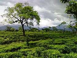
The Dooars are famous for the tea gardens which were planted by the British. For working in the gardens, they imported labour from Nepal and the Chota Nagpur and Santhal Parganas. The Oraons, Mundas, Kharia, Mahali, Lohara and Chik Baraik are the tribals from these areas. The tribal of Chotanagpur origin are employed in tea gardens, which started production during the 1870s. Before the settlement of other communities, these people converted the forests into villages and busties (agriculture village). The remnants of these tribal people form a majority of the population in Western Dooars.
Cities and towns
The Dooars is a large region and is dotted with many towns and cities. The largest city in the whole region stretching from the Darjeeling foothills to the Arunachal Pradesh foothills is Siliguri. This northern Bengal city is well connected with the rest of country by road, air and railway and is the business hub of the region.
The other major cities are Kokrajhar, Bongaigaon, Goalpara, Barpeta and Dhubri in Assam. Cooch Behar, Alipurduar, Jalpaiguri, Dhupguri, Malbazar, Mainaguri and Birpara are the major cities of the Dooars in West Bengal, and Kishanganj in Bihar. Also, the commercial capital of Bhutan, Phuentsholing, near Jaigaon, can be considered a part of this region.
Politics
Historically, the region has suffered from ethnic strife. The Bodoland agitation in Assam for a separate state for the Bodo people and the Kamtapur or Greater Cooch Behar movement for a Kamtapur state in northern Bengal for the Rajbongshis are the two most vociferous ones.The Adivasi (Tribal) of Dooars are demanding autonomy under the Sixth Schedule of the Indian Constitution. The Gorkhas have also demanded that the area be included in their territory. The Indian Nepali speaking known as Gorkha are also demanding for statehood called "Gorkhaland"
Economy
The economy of Dooars is based on three "T"s – Tea, Tourism and Timber. The main industry of the Dooars region is the tea industry. Thousands of people are engaged in the tea estates and factories. Several people are also engaged in the cultivation of bettlenuts which also contributes to the economy. Cultivation of other crops is done mainly for local consumption.
The area is dotted by several national parks and wildlife sanctuaries which attract a lot of tourists from all over India and abroad, making it an important contributor to the economy and also employer of a number of people.
The timber industry, both legally and illegally, flourishes in this region. A number of saw mills, plywood industries and other allied business also act as an important contributor to the economy.
The Dooars act as doorways to Bhutan; thus, the export-import industry also flourishes in the area. The towns of Jaigaon, Siliguri and Phuentsholing are important hubs of the export-import industry.
As the region is near the international borders of Bhutan, Nepal and Bangladesh, the Border Security Force (BSF), the Central Reserve Police Force (CRPF), Indian army and Indian Air Force maintain a large presence in the area. This leads to a large population of semi-permanent residents who bring money into the local economy.
Forests and animals
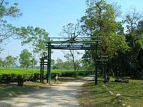
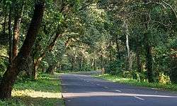
The beauty of the region lies not only in its tea gardens but also in the dense jungles that make up the countryside. Many wildlife sanctuaries and national park like Manas National Park in Assam, Jaldapara National Park, Buxa National Park, Gorumara National Park, Chapramari Wildlife Reserve and the Mahananda Wildlife Sanctuary in West Bengal are located in this region.
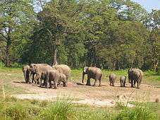
A number of rare endangered species of animals like tiger, rhinoceros and elephant make their habitat in the forests of the Dooars. Other animals includes different types of deer, bison, birds and reptiles. A railway line runs through the tea gardens and the various protected areas and a number of elephants have been killed in collisions with trains.[2]
Places of Interest
- Jayanti
- Bhutanghat
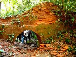
- Buxa Fort
- Malbazar
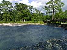
- Teesta River
- Hasimara
- Coronation Bridge
- Phuntsholing
- Chalsa
- Rajabhatkhawa
Transport
The main mode of transport in the area is roadways. Most of the places are well connected by roads. NH31 is the main highway of the area. Asian Highway AH48 is being constructed through the Dooars region.
Regular bus services provided by North Bengal State Transport Corporation and Assam State Transport Corporation and other private parties run between all the important places of the area. Shared jeeps and maxi-taxies are quite popular in the area.
There are some important railway stations in the area such as New Jalpaiguri, New Cooch Behar, Alipurduar, New Bongaigaon, hasimara, etc. An important rail route between Alipurduar Junction and New Jalpaiguri via Malbazar covers almost the entire Dooars.
Two important airports of the area are Bagdogra Airport near Siliguri and Guwahati Airport. Another airport is proposed to start in Cooch Behar shortly.
References
- ↑ West Bengal Tourism
- ↑ http://articles.timesofindia.indiatimes.com/2010-09-24/india/28266507_1_elephants-goods-train-animesh-basu Goods train mows downs 7 elephants
- http://www.westbengaltourism.gov.in/web/guest/dooars-main
- http://coochbehar.nic.in/htmfiles/dooars.html
External links
| Wikimedia Commons has media related to Dooars. |