Du Lièvre River
| Le Lièvre River (Rivière du Lièvre) | |
| Hare River | |
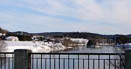 Le Lièvre River at Notre-Dame-de-la-Salette | |
| Country | Canada |
|---|---|
| Province | Quebec |
| Region | Laurentides, Outaouais |
| Source | Laurentian Mountains |
| Mouth | Ottawa River |
| - location | Masson, Outaouais |
| - coordinates | 45°31′25″N 75°25′50″W / 45.52361°N 75.43056°WCoordinates: 45°31′25″N 75°25′50″W / 45.52361°N 75.43056°W |
| Length | 330 km (210 mi) |
| Basin | 10,400 km2 (4,000 sq mi) |
The Le Lièvre River (Rivière du Lièvre in French; French pronunciation: [ʁivjɛʁ dy ljɛvʁ]) is a river in western Quebec which flows south from the Mitchinamécus reservoir and empties into the Ottawa River at Masson-Angers. The river is 330 kilometres (210 mi) long and drains an area of 10,400 square kilometres (4,000 sq mi). The river's name comes from the French word for hare.
The 1908 landslide at Notre-Dame-de-la-Salette and the earlier 1903 clay landslide at Leda both occurred on this river.
At one time, the river was used to transport logs downstream to sawmills located near the river's mouth. In 1928, a paper mill was built near the mouth of the river. On December 18, 1998, this mill was bought from Industries James Maclaren Inc. by private investors and became Papier Masson Ltee. In turn, the White Birch Paper Company bought it in January 2006.[1][2]
There are a number of hydroelectric plants on the river, as well as large and viable deposits of Uranium ore in the district.
Tributaries
- Mitchinamécus River
- Kiamika River
Communities
- Mont-Laurier
- Notre-Dame-de-Pontmain
- Notre-Dame-du-Laus
- Val-des-Bois
- Notre-Dame-de-la-Salette
- Glen Almond (municipality L'Ange-Gardien)
- Buckingham now part of Gatineau
References
| Wikimedia Commons has media related to Rivière du Lièvre. |
- ↑ Papier Masson ltd History
- ↑ White Birch Paper Company announces completion of acquisition of Papier Masson Ltee