Driver location sign
Driver location signs are signs placed every 500 metres (550 yd) along each side of English motorways, and some other major English roads, to provide information that will allow motorists to know their precise location. Only roads in England feature these signs; they are not found on roads in Scotland, Wales or Northern Ireland. This information might be useful in the event of an emergency or breakdown. They were first introduced in 2003, and they complement distance marker posts (small roadside posts used for road maintenance and administrative purposes). Both types of sign display a unique location number. The number, although given without units, is the distance in kilometres from a designated datum location for the road.
While the driver location signs are metric, other road signs throughout the UK use imperial measurements (miles and yards).
History
Distance marker posts
Since at least 1980, motorways have had distance marker posts installed at 100 metre intervals alongside the hard shoulder.[1][2] These posts are used to help pinpoint road locations for maintenance and emergency purposes, and also show the direction to the nearest emergency roadside telephone.[1] The numbers on the posts, for which no units are given, are derived from the distance, in kilometres, of the post from a reference datum location such as a city centre, an administrative boundary or some other feature. On the M25 for example, distances are referenced to a point near Junction 31 even though the section of the ring road between Junction 31 (post 186.6) and Junction 1a (post 5.7) is the A282, not the M25.[3] On motorways distance marker posts also bear an arrow pointing towards the location of the nearest emergency telephone.[4]
The number used on distance marker posts is also encoded into the numbers associated with motorway emergency roadside telephones.[5] In this way motorway control centre staff can pinpoint the telephone from which a call is being made.[4][6][7]
Items of highway furniture are commonly uniquely identified by a code number attached to or stencilled onto them.[8] On motorways the number from the closest distance location marker is generally incorporated into such identifiers. They are also sent in the signal from traffic cameras to identify the location of the camera.[9][10]
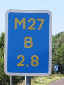
Driver location signs
These signs give the same location information as distance marker posts, but more visibly on larger signs, which are generally placed at 500-metre (547-yard) intervals. If obstacles prevent signs from being spaced at 500-metre intervals, then the interval must be reduced to either 400 or 300 metres (437 or 328 yd). By the end of the 2009 financial year, 80 percent of England's motorway network had been fitted with 16,000 driver location signs at a cost of £5.9 million (about £570 each). It was expected that the remaining 20% of the motorway network would be covered by April 2010 at a cost of £1.6 million.[2] As of July 2009 driver location signs had not been erected in Scotland, Wales or Northern Ireland.

By the early 2000s mobile phones were being used as the primary means of reporting accidents.[11] This required the government to rethink marker posts. By early 2007, after experiments in the preceding four years on parts of the M25 and M6 showed a 10% improvement in emergency service response times,[2] a programme to erect driver location signs at 500-metre (547 yd) intervals on many motorways was commenced in England.[1][12] The need for more visible roadside location information was shown in 2007, in an incident on a motorway before the driver location signs had been erected. The Devon and Somerset Fire & Rescue Service reported that after a serious collision on the M5, their control centre was inundated with mobile phone calls from drivers. Callers gave the operators locations stretching over 40 miles (64 km) of road. As a result, four emergency service centres were mobilised instead of just one.[13]
Research on trial sections of motorways showed that emergency service organisations responded 10 percent more rapidly when a motorway had driver location signs than when it did not. Driver locations signs are more visible than the small distance marker posts, enabling motorists to know their location more accurately and emergency services to reach incidents more quickly.[2] The analysis of an exercise run by the Highways Agency (Exercise Hermes) in which a serious traffic accident was simulated reported that call handlers in control rooms should request marker post or location sign locations when taking calls from members of the public.[14]
Driver location signs have three pieces of information:
- The road identifier
- The carriageway identifier
- The location
The location is identical to the location given on marker posts. The most commonly used carriageway identifiers are the letters “A”, “B”, “J”, “K”, “L” and “M”.[15] The letter “A” ("Away from London") normally (but not always) [16] denotes carriageways leaving London (or clockwise in the case of the M25 & M60) and "B" ("Back to London") is used for carriageways going to London (anticlockwise on the M25 & M60). Location numbers increase in the direction of travel of the "A" carriageway, and decrease in the direction of travel of the "B" carriageway. The letters "J", "K", "L" and "M" denote junction slip roads. This is illustrated below.

Letters "C" and "D" have been allocated for service roads adjacent to the "A" and "B" carriageways.[15] The regulations require that each driver location sign be unique within the United Kingdom.[1]
Rerouting
If a road is rerouted, then it is highly likely that there will be some changes in the end-to-end length of the road concerned which could affect the values on driver location signs. The publicly available Highways Agency documentation does not cover this possibility,[15] but it will be noticed that the four carriageway identifiers "E", "F", "G" and "H" have not been allocated.
Governing legislation
Section 64 of the Road Traffic Regulation Act 1984 authorises the Secretary of State for Transport to regulate the design of road signs in England, Scotland and Wales. The Traffic Signs Regulations and General Directions 2002 (TSRGD)[17] was issued under this authority. Although the TSRGD makes no provision for the use of driver location signs, both the Act and the TSRGD give the Secretary of State the power to authorise other signs as appropriate. The Secretary of State used this provision to authorise the design of driver location signs and to use the same location information on them as on the distance marker posts.[1]
Public awareness
In a road users satisfaction survey conducted during the second quarter of 2012 in the M25 area, respondents were shown a picture of a driver location sign and asked whether they had seen similar signs and also what they thought the signs were for. Some 59% of respondents had seen such a sign, but 76% of drivers did not know what the signs were for.[18]
See also
References
- 1 2 3 4 5 Highway Agency (December 2010). "Interim Advice Note 93/10 (Revision 1) – Driver Location Signs Interim Performance Specification" (PDF). Retrieved 16 December 2010.
- 1 2 3 4 Hansard. "21 Oct 2009 : Column 1446W". Retrieved 4 November 2009.
- ↑ "M25 Road Network Driver Location Signs" (PDF). Highways Agency. Retrieved 13 May 2011.
- 1 2 Highways Agency. "Driver Location Signs – Frequently Asked Questions". Retrieved 10 February 2010.
- ↑ "Practice Advice on the Policing of Roads" (PDF). National Policing Improvement Agency. 2007. p. 58. Retrieved 8 March 2013.
- ↑ Know Your Traffic Signs (PDF). London: Department for Transport. 2010. p. 143. ISBN 978-0-11-552855-2. Retrieved 26 January 2011.
- ↑ Automobile Association. "Breakdown Advice". Retrieved 10 February 2010.
- ↑ "Highways Agency Strategic Plan for Integration". Highways Agency. Retrieved 21 April 2010.
- ↑ "Traffic Cameras". Highways Agency. Retrieved 23 April 2010.
- ↑ "Live traffic information covering England's motorways and major A roads". Highways Agency. Retrieved 21 April 2010.
- ↑ Highway Agency. "Driver Location Signs (March 2007)". Retrieved 23 July 2009.
- ↑ Highway Agency. "Driver Location Signs (Driver Location Signs)". Retrieved 7 June 2009.
- ↑ "Motorway Markers". Devon and Somerset Fire & Rescue Service Newsdesk. 31 August 2007. Retrieved 12 November 2010.
- ↑ "Exercise Hermes". Highways Agency. January 2010. Retrieved 30 March 2010.
- 1 2 3 Highway Agency. "Identification of Incident Locations". Retrieved 11 June 2009.
- ↑ For example the M32
- ↑ "Statutory Instrument 2002 No. 3113; The Traffic Signs Regulations and General Directions 2002". Controller of HMSO. 16 December 2002. Retrieved 12 June 2010.
- ↑ "Area 5 Road Users' Satisfaction Survey February to July 2012" (PDF). Highways Agency. p. 14. Retrieved 3 March 2013.