Downtown Tulsa
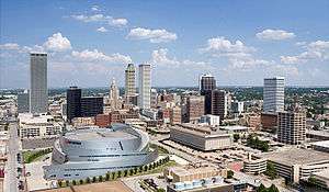
Downtown Tulsa is an area of approximately 1.4 square miles (3.6 km2) surrounded by an inner-dispersal loop created by Interstate 244, Highway 64, and Highway 75.[1] The area serves as Tulsa's financial and business district, and is the focus of a large initiative to draw tourism, which includes plans to capitalize on the area's historic architecture.[2] Much of Tulsa's convention space is located in downtown, such as the Tulsa Performing Arts Center and the Tulsa Convention Center, and the BOK Center. Prominent downtown sub-districts include the Blue Dome District, the Brady Arts district, and the Greenwood Historical District, Owen Park Historical Neighborhood, the site of ONEOK Field, a baseball stadium for the Tulsa Drillers opened in 2010.[3][4][5]
In 2010, the estimated population of downtown is 4,000.[6] The daytime population is estimated to be 36,000.[7]
Downtown districts
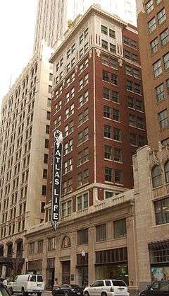
Tulsa includes many structures built during the Oil Boom in the 1920s and 1930s, including Art Deco buildings such as the Mid-Continent Tower, Boston Avenue Methodist Church, and the Exchange Bank Building (today known as the 320 South Boston Building). Oilman Waite Phillips, left a significant architectural impact on downtown Tulsa through the Philtower and Philcade buildings. Other notable Tulsa buildings include the Atlas Life Building, Holy Family Cathedral, Holy Trinity Greek Orthodox Church, and the Mayo Hotel, the former of which once served as home to J. Paul Getty. Known for a time as "Terra Cotta City",[8] Tulsa hosted the International Sixth Congress on Art Deco in 2001.
Downtown Tulsa is in the northwest quadrant of the city and is ringed by an expressway system called the inner dispersal loop. Downtown's buildings include many large office towers. At 667 ft (203 m), the BOK Tower (formerly One Williams Center) was the tallest building in any of the 5 "plains states" (Oklahoma, Kansas, Nebraska, North Dakota and South Dakota) until the Devon Tower in Oklahoma City was completed. The BOK Tower was designed in 1975 by Minoru Yamasaki & Associates, the same architect who designed the World Trade Center in New York City.
The Tulsa Performing Arts Center occupies a half city block in Tulsa's historical downtown. The PAC is also the design of Minoru Yamasaki. It houses five theatres and a reception hall. More than a quarter of a million people visit the Center each year to attend a performance from one of Tulsa's seven acclaimed musical and dramatic companies including the Tulsa Ballet, Tulsa Symphony Orchestra, Tulsa Opera, and a variety of symphonic groups. The PAC hosts a multitude of cultural events through the fall, winter and spring.
In 2005 the City of Tulsa broke ground on a 19,199 seat regional events center designed by architect César Pelli. The arena was named the BOK Center (or Bank of Oklahoma Center) and opened on August 30, 2008.
Tulsa Civic Center Historic District

The Tulsa Civic Center Historic District (CCHD) is an area that contains most of the important buildings that house the governments of the City of Tulsa and Tulsa County. It was constructed between 1955 and 1969. It is located in Downtown Tulsa and is bounded on the north by 3rd Street, on the east by Denver Avenue, on the south by 6th street and on the west by Houston Avenue.[9]
The CCHD was listed on the National Register of Historic Places (NRHP) on January 3, 2012 under Category G, Exceptional Significance, Criteria A and C for community planning. The NRIS number is 11000641.[9]
Blue Dome District
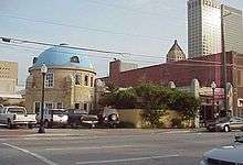
Another popular downtown entertainment district is the Blue Dome, named for a distinctive, domed building at Second Street and Elgin Avenue, in the area in the eastern section of downtown. The building was originally constructed in 1924 as a Gulf Oil service station. It has been converted to an information desk/office for the district, and is about two blocks south of the OneOK field.
Brady Arts District
The Brady Arts District is located north across the Sante Fe Railroad tracks from the central business district and centered at Main Street & Brady Avenue. The Brady District is one of Tulsa's oldest areas, characterized by two-story brick warehouses.
The Brady Theater, built between 1912 and 1914, was originally designed to serve as the city's municipal auditorium and was simply called "Convention Hall" for the first forty years of its life and was one of three internment camps where African Americans were detained after the 1921 Tulsa Race Riot. In 1952, major additions were added and the building was renamed Tulsa Municipal Theater. The building was listed on the National Register of Historic Places in 1979. Supplanted as the city auditorium in 1979 by construction of the Performing Arts Center in downtown, "the Old Lady on Brady" continues to be used today for a wide variety of concerts and theatrical productions.
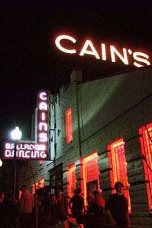
North of the Brady on Main Street is the Cain's Ballroom, formerly the garage of the Brady family[10] and the home of Bob Wills and his band, the Texas Playboys. The district is also the location of many local artists' galleries, restaurants with late night hours, bars and dance clubs. It is also an emerging gay neighborhood, with several gay or gay-friendly bars and numerous supportive shops and restaurants.
Today, The Brady Arts District is one of the most diverse areas in all of Tulsa. It hosts restaurants, clubs, museums, and businesses and is a prime example of urban living. There is presently construction which will more than double the number of permanent residents in this artistic conclave. On its present path, the area will continue to develop as a hub of the community welcoming all people as it acknowledges its past while looking to a vibrant and inclusive future.
Brady Heights Historic District
Brady Heights is a historic district in Tulsa, Oklahoma named for early resident, W. Tate Brady. Its boundaries are Marshall Street on the north, the alley between Cheyenne Avenue and Main Street on the east, Fairview Street on the south, and the Osage Expressway right-of-way on the west. From territorial days until the 1920s, Brady Heights was an important part of the then-fashionable north side of Tulsa. Young professional businessmen and oil men, like G. Y. Vandever, I. S. Mincks and “Diamond Joe” Wilson, owned homes there.
East Village
East Village comprises 115 acres bordered by East 2nd and East 7th Streets, Detroit Avenue and Lansing Avenue, just inside the inner-dispersal loop.[11] This area boasts an upscale martini bar, a hair salon, a pet day care, photography studios, lofts, a knitting room and living arts district, among others. The cornerstone of this neighborhood is the fifth largest LGBT community center in the United States, the Dennis R. Neill Equality Center, owned and operated by Oklahomans for Equality/OkEq (formerly Tulsa Oklahomans for Human Rights/TOHR), with further development being planned for more restaurants, residential lofts and retail.
Greenwood Historical District
The Greenwood Historical District is just north of downtown and east of the Brady District. It was once one of the most affluent African-American communities in the United States and referred to as Black Wall Street. In 1921, thirty-five blocks of businesses and residences were burned in this district during the infamous Tulsa Race Riot, the bloodiest racial riot in the history of the United States. The Oklahoma Legislature passed laws in 2001 aimed at revitalizing Greenwood, setting up a scholarship fund for college-bound descendants of riot victims and appropriating $2 million for a riot memorial. As of 2004, two blocks of the old neighborhood have been restored and are part of the Greenwood Historical District. It is now home to the Greenwood Cultural Center, the Tulsa Race Riot Memorial, and the Oklahoma Jazz Hall of Fame, as well as Oklahoma State University - Tulsa and Langston University-Tulsa.
Oil Capital Historic District
The Oil Capital Historic District was added to the National Register of Historic Places in 2010. It is bounded by Third Street on the north, Seventh Street on the South, Cincinnati Avenue on the east and Cheyenne Avenue on the west. This area contains many of the historic Downtown office buildings constructed during the 1920s and 1930s.[12]
SoBo

Riverview stretches along the east bank of the Arkansas River, just west of Downtown. The SoBo (South Boston) bar district in this area at 18th and South Boston is quite popular. The Ambassador Hotel, now listed on the National Register of Historic Places, was built in 1929 to provide temporary housing for businessmen and now functions as a boutique hotel. The building is at the corner of Main and 14th Street. The Tulsa Preservation Commission identified this location as "...the Southeast Business Area of the Riverview section of Tulsa."[13]
Riverview Historic District

Riverview is bounded on the north by 12th and 13th Streets, on the east by the alley between Denver and Elwood Avenues, on the south by Riverside Drive and 14th Place, and on the west by Jackson Avenue. The name came from Riverview Elementary School, which was at 12th and Guthrie. Although the school building was demolished in 1975, the district retained its name.This area contains houses and apartment buildings constructed between 1911 and 1938. Included are several structures that are individually listed on the National Register of Historic Places.[14]
Economy
Major employers in Downtown Tulsa include the corporate headquarters of Williams Companies and ONEOK.[15][16] BOK Financial is headquartered there as well.
Media
The Tulsa World and This Land Press have their headquarters in Downtown Tulsa.
Gallery
-

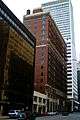
Downtown Tulsa
-
Tulsa Municipal Building
-
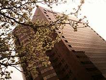
Looking North along Boston Avenue from 6th Street
-

First National Bank Building
-
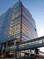
Williams Technology Center
-
Downtown buildings
-

320 S. Boston Building
-
First National Bank Building and First Place Tower
-

Bartlett Square at 5th and Main

See also
References
- ↑ "Quick Facts". Downtown Tulsa Unlimited. Archived from the original on 2007-05-02. Retrieved 2007-04-14.
- ↑ "Walk to tie city's projects together". Land Legacy. 2005-12-25. Retrieved 2007-04-14.
- ↑ Lassek, PJ (2008-06-25). "Tulsa Drillers stadium coming downtown to Greenwood District". Tulsa World. Retrieved 2008-09-19.
- ↑ Lassek, PJ (2008-12-19). "City breaks ground on downtown ballpark". Tulsa World. Retrieved 2008-12-19.
- ↑ Lassek, PJ (2009-01-13). "Baseball park named Oneok Field". Tulsa World. Retrieved 2009-01-13.
- ↑ http://www.tulsaworld.com/opinion/article.aspx?subjectid=213&articleid=20120401_213_G6_CUTLIN701527#
- ↑ http://www.cbre.us/o/tulsa/properties/one-place-tower/Pages/overview.aspx
- ↑ Tulsa City-County Library, "Art Deco in Tulsa." Accessed August 22, 2011.
- 1 2 "Tulsa Civic Center Historic District." Tulsa Preservation Commission. Retrieved November 8, 2014.
- ↑ This Land, "The Nightmare of Dreamland." Accessed September 12, 2011.
- ↑ Easterling, Mike. "East Village: Dead or Alive?." March 25, 2009. Accessed September 7, 2011.
- ↑ Krehbiel, Randy. Tulsa World. "3 Tulsa areas added to National Register." December 28, 2010. Retrieved November 21, 2011.
- ↑ Tulsa Preservation Commission. "Ambassador Hotel." Retrieved November 19, 2011.
- ↑ Tulsa Preservation Commission. "Riverview Historic District." Retrieved December 27, 2011.
- ↑ http://co.williams.com/contact-us/
- ↑ http://www.oneok.com/en/About.aspx