Downtown St. Catharines


The downtown core of St. Catharines, Ontario, Canada is defined by the city as the area between Highway 406 on the west and south, Geneva Street on the east until it reaches St. Paul Street then Niagara Street north until it meets Welland Avenue.
The area was originally known as a storehouse for goods at the crossing of an Iroquois trail over Twelve Mile Creek. Curving Indian trails formed the foundation of the downtown streets as they appear today. Among them remains the largest and most historically significant of the city, St. Paul Street - the spine of Downtown St. Catharines. Construction of the first and second Welland Canals behind St. Paul Street quickly elevated the area into a prosperous hub for commerce and industry in the Niagara Region.
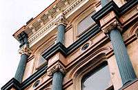
The downtown's extensive history left an impressive showplace of heritage sites in the core. Architectural landmarks reveal the stories behind St. Catharines varying roles as the former seat of Lincoln County, a popular health-spa destination, and the premiere retail centre for Niagara. Like many downtowns in North America, the area experienced significant decline as shopping malls and power centres in the suburbs took over as major shopping destinations. Today, the downtown is experiencing its lowest vacancy rate since 2000, with over 120 shops, boutiques and over 50 culinary establishments. It has become particularly popular among Brock University and Niagara College students who frequent the many bars and clubs that are centred on St. Paul & James Streets.
Citizens of St. Catharines often complain of the lack of parking and inconveniences associated with one-way streets in the core. On April 3, 2006, St. Catharines City Council voted in favour of returning two-way traffic to the downtown core, at an anticipated cost of $2 million. As of October 2009, most of the conversion work is complete but is too early to determine whether two-way traffic has been successful in making streets safer, slowing down traffic and boosting business. The addition of two-way traffic, especially to St. Paul Street, played a role in the Ontario Wine Council's decision to modify the Niagara Wine Route to pass through downtown St. Catharines in 2014.[1]
On June 16, 2006 the Province of Ontario released a Growth Plan under the Places to Grow Act, 2005. In the plan, Downtown St. Catharines was one of 22 places identified as an Urban Growth Centre, which will give the area a growth target of 150 residents and jobs combined per hectare by 2031.
Since the Places to Grown Act, municipal and regional governments have invested heavily in infrastructure projects in the downtown core. A detailed inspection and analysis of the Burgoyne Bridge in 2010 revealed the need for a new span over Twelve Mile Creek. Construction on the new signature bridge, which features a steel truss-arch, began in 2014 with an estimated budget of $91.35 million.[2] In the nearby Lower Level Parking Lot, construction began in 2013 on the Marilyn I. Walker School of Fine and Performing Arts, a new campus of Brock University. When completed in 2015, the school will operate alongside the city's new FirstOntario Performing Arts Centre, which is also under construction on adjacent lands, and will house 500 full-time students in new buildings along St. Paul Street and the historic Canada Hair Cloth building.[3]
The grand opening of the city's new spectator arena, the Meridian Centre, took place on October 21, 2014. The 5,300 seat arena was built by the municipality to house the Niagara IceDogs ice hockey team of the Ontario Hockey League.
Places of interest
- BME Church & Salem Chapel - A national historic site, played an important role during the abolitionist era and frequented by Harriet Tubman, the famed conductor of the Underground Railroad.
- City Hall - Built on the site of the previous City Hall, this building was officially opened in August 1937 at the corner of Church and James Streets. Designed by local architect Robert Macbeth, the structure was originally built to accommodate all city departments, including a police station and jail in the basement. In 1963, the building was extensively renovated, however, most of the significant elements found inside, such as the main entryway, its marble floors, ornate ceiling and wide sweeping staircase, were left intact.
- Farmers' Market - One of the oldest farmers' markets in Ontario, dating back to the early 1860s. It continues to operate every Tuesday, Thursday and Saturday, as it did over a century ago.
- Mansion House - Thought to have been constructed in the early 19th century by William Hamilton Merritt, it is the oldest tavern in St. Catharines and the oldest continually licensed bar in Canada.
- Montebello Park - Designed by Frederick Law Olmsted in 1887, who went on to create New York City's Central Park. A commemorative rose garden with over 1,300 bushes in 25 varieties is the city's largest rose collection and features an ornamental fountain. The focal point of the park is a band shell and pavilion built in 1888. The park is designated under the Ontario Heritage Act.
- Old Courthouse - Built in 1848-49, the Old Courthouse was the centre of political, cultural and social life in St. Catharines. Designed by renowned architect Kivas Tully, it was hailed as a great architectural achievement. The existing building soon became too small and an addition was added in 1863-65. Today, the building is home to Carousel Players, an independent theatre group, and recently underwent an extensive restoration.
- Queen St. Heritage District - An historically and architecturally significant neighbourhood in the downtown core.
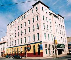
- Welland House Hotel - One of the few surviving symbols of the city's extensive health spa history. Today the building is home to a student residence and CFBU, Brock University's campus radio station.
- Yates St. Heritage District - Stately Victorian era homes line this street of what was once a thriving canal-side village. The remnants of the original Welland Canal can still be seen at the bottom of the cliff on which this street is perched.

Heritage Corridor
The St. Catharines Economic and Tourism Services department, with support from the Ontario Ministry of Tourism, launched the Heritage Corridor Project in 2004. The goal of the project is to draw tourists off the Niagara Wine Route into St. Catharines' downtown and other historically significant areas.
Places to live
A few streets within the St. Catharines Downtown Core where the houses are primarily used for residential purposes.
- Yates Street - Stately Victorian era homes line this street which overlooked the First and Second Welland Canals.
- Montebello Place & Queen Street - Historic and architecturally significant homes. The corner of Montebello and Welland Avenue will soon be home to new townhouse style condominiums.
- James Street (north of Church St.) - Mainly consisting of rental units, but also has historic and architecturally significant buildings. Many can watch the Wine Festival's Grande Parade from their front porch.
- Gerrard & Beecher Streets - Cosy community within the Downtown Core with many historic homes, some dating back to the 1860s. Many improvements in the neighbourhood make this area an up-and-coming destination for those seeking to live in the Downtown Core.
SmartGrowth
The Gerrard, Beecher, and James Street area scored 'Pretty good' in the "Walkability ranking of your community", a program which evaluates how well a neighbourhood rates as a village, provided through the Ontario Smart Growth Network.

Places to work
The St. Catharines Downtown Core provides many places of employment. Here are a few:
- Retail stores - Various retail stores are located throughout the core.
- Law firms - Various law firms are located throughout the core, a number of which are located near the Courthouse on James Street known as "Lawyers' Row".
- Banking institutions - Various Banks occupy the area within the Core known as the financial district. These include CIBC, Royal Bank, TD Canada Trust, ScotiaBank, HSBC, and more.
- Information Technology - MTO is the largest employers of IT jobs in the core.
- Call Centres - The new Corbloc, Garden City Tower and Church Street are home to a few call centres operating within the Core.
- Municipal government - City Hall located at James and Church Streets.
- Regional government - The Niagara Regional Police headquarters located on Church Street.
- Provincial government - The Garden City Tower is home to a number of Ministries, the largest being the Ministry of Transportation.
- Federal government - Canada Revenue Agency on Church Street.
Lost heritage
- The Grand Opera House (1877–1998) - With seating for 1200, the facility opened to much fanfare as a centre for musical production on Ontario Street. Over the years it housed an orchestra and featured numerous concerts and vaudeville shows. After a fire ravaged the building's facade and most of its interior, there was some public interest in restoring what was left of the auditorium, but the city and some professionals concluded that renovations would be much too costly and the site was levelled. The site is used today as a parking lot.
- The Canada Hair Cloth Company Ltd (1882–2007) - An industrial factory for over a century, the building closed in 2007 and will be home to Brock University's Marilyn I. Walker School of Fine and Performing Arts.
- The Russell Hotel
References
- ↑ "Wine Route Has Arrived in Downtown St. Catharines". St. Catharines Economic Development and Tourism Services. Retrieved 18 June 2014.
- ↑ "Task Force Created to Look Into Burgoyne Bridge Replacement". Canoe Sun Media. Retrieved 7 May 2015.
- ↑ "With construction finished, Brock's new downtown arts school gets ready to educate". The Brock News. Retrieved 1 June 2015.
External links
- St. Catharines Downtown Association — map of downtown
- The Underground Railroad - Niagara's Freedom Trail
- City of St. Catharines Tourism Homepage
Coordinates: 43°09′30″N 79°14′50″W / 43.15833°N 79.24722°W