Downside, Surrey
| Downside | |
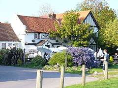 The Cricketers' Inn, Downside |
|
 Downside |
|
| Population | 6,564 (2011 Census. Chobham and Downside Ward)[1] |
|---|---|
| OS grid reference | TQ109581 |
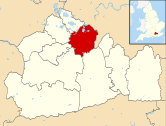
| District | Elmbridge |
| Shire county | Surrey |
| Region | South East |
| Country | England |
| Sovereign state | United Kingdom |
| Post town | Cobham |
| Postcode district | KT11 |
| Dialling code | 01932 |
| Police | Surrey |
| Fire | Surrey |
| Ambulance | South East Coast |
| EU Parliament | South East England |
| UK Parliament | Esher and Walton |
Coordinates: 51°18′42″N 0°24′34″W / 51.311658°N 0.409531°W
Downside is a small village in the English county of Surrey, most of buildings of which form a cluster, in the local government district of Elmbridge, centred on Downside Common which is 18 miles (29 km) southwest of London and 8.4 miles (13.5 km) northeast of Guildford, the county town. It has an inn, Downside Sports and Social Club, regular village hall events and an annual sports day. At the 2011 Census the population was included in the Cobham and Downside ward of Elmbridge Borough Council.
History
Toponymy
The village was a tything named after the Downe family, where they lived since at least the 12th century.[2][3]
Early history
in 1331 the prior and convent of Newark by Guildford acquired 100 acres (40 ha) from John Prudhomme held of Henry de Somerbury, who held of Henry atte Downe, who held of Chertsey Abbey.[3] Cobham Park was first known as Downe Place after this family.[2] Much of the village green was part of a common open to those with villager status of the Downeside Tything as opposed to the two others: Street Cobham and Church Cobham. As to the manors that were in private hands in the Middle Ages, see the parish of Cobham, as Downside's chapel was built on land in Cobham ecclesiastical parish.
Neither of the settlements is a civil parish and the church became tied with that of Ockham at an unknown date after its 19th-century construction.
Downside Village was designated as a Conservation Area in 1979, focussed around its developed, village green area.[4]
Geography
A rural community, Downside (and the adjacent hamlet of Hatchford) is situated in open countryside between Cobham to the north and East Horsley to the south, Stoke D'Abernon to the east and two similar size settlements across the Surrey Wildlife Trust expanse of Wisley Heath and Ockham Common: Ockham and Wisley to the west. London is 18 miles (29 km) northeast, Guildford is 8.4 miles (13.5 km) southwest. Local administrative centre of Elmbridge, Esher ![]() i/ˈiːʃər/, is 4.4 miles (7.1 km) NNE.[5]
i/ˈiːʃər/, is 4.4 miles (7.1 km) NNE.[5]
This elevated community is part of the Green Belt. Immediately to the south of the village is the M25 motorway, where construction of a motorway service station began, despite determined local opposition, in 2011. To the north is Cobham Park, a large country house that has been converted to apartments.
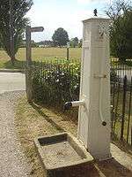
Downside has a large village green, on the northern edge of which is the Cricketers' Inn, dating at its core to the 17th century and a Grade II listed building.[6][7] Immediately off the green in the south east corner is a listed hand-operated water pump.[8]
Elevations, Soils and Geology
Elevations of the central part of Downside, on all sides of the Common vary from 36 metres (118 ft) AOD in the southwest to 27 metres (89 ft) Above Ordnance Datum in the northeast, while the common itself ranges between 29-33m AOD. Immediately north of this the River Mole begins to cut a valley and in Cobham, most of which, excluding Fairmile is at 18-22m AOD.[5] [9]
Not within the narrow belt of raised soils of the north Surrey belt of acidic, sandy raised heathland of the Bagshot Formation, the soil stretching from Cobham and Downside as far as Effingham and for a more considerable distance east and southwest is "slowly permeable loamy/clayey slightly acid but base-rich soil", which gives rise to flora of trees, grasses and crops or which can be cultivated easily.[10] As the later sandy soil mentioned above and certainly further chalk overlayers have been washed away, whereas sand may have been scant, hence why it appears further north; the geology of Downside is Cretaceous: i.e. Hastings Beds, Weald Clay, then pleistocene Folkestone and then covered by a considerable remaining layer of Claygate Beds, Gault Clay mixed in with some eroded limestone from the north downs in the soil to the south.[11]
Demography
In 2001, the central output area of Downside contained 306 residents in 126 households of which 11.4% were aged over 65; 6.0% of the population were in full-time further education; 70.6% of those of working age were economically active whereas 0.0% were unemployed, 11.7%[12]
As to ethnicity, 89.5% of the population identified themselves as being White British ethnicity, 2.0% as of White Irish ethnicity and 8.5% as White Other of the categories available.[12]
In terms of religion, 76.0%% of the population responded as being Christian, 1.3% as Jewish, 16.4% as atheist and 6.2% declined to answer.[12]
Downside's economy is predominantly a service sector economy reflected by the lowest versus the upper end of the official categorisation table of occupation given, compiled from the 2001 census:
| Category | Number of adults in category in 2001 | Percentage of those aged 16–74 |
|---|---|---|
| Elementary occupations | 24 | 14.9% |
| Managers and Senior Officials | 44 | 27.4% |
| Professional Occupations | 15 | 9.3% |
| Skilled Trades Occupations | 23 | 14.3% |
| Administrative and Secretarial Occupations | 16 | 9.9% |
| Associate Professional and Technical Occupations | 6 | 3.7% |
Religion
St Michael's Chapel by the village green serves the village's Church of England community and those seeking its help in the Diocese of Guildford, at the end of the only fully developed street.[13]
Culture and Community
Downside Sports & Social Club operate with a mixture of cricket, bowls, football and entertainment. Downside Village Hall hosts voluntary-run classes and meetings for local groups and organisations.
Downside village green, historically and legally Downside Common, is the setting for the Downside & Hatchford Sports Day, held annually on August Bank Holiday Monday.
Education
St. Matthew's Church of England Infant School serves the wider area of Downside including Cobham.[14]
References
- ↑ "Ward population 2011". Neighbourhood Statistics. Office for National Statistics. Retrieved 6 October 2016.
- 1 2 Edward Wedlake Brayley; John Britton (1841). A topographical history of Surrey, by E.W. Brayley assisted by J. Britton and E.W. Brayley, jun. The geological section by G. Mantell. pp. 412–. Retrieved 14 April 2013.
- 1 2 H.E. Malden (editor) (1911). "Parishes: Cobham". A History of the County of Surrey: Volume 3. Institute of Historical Research. Retrieved 29 October 2013. this refers to three layers of landlords who were also feudal overlords, see subinfeudation.
- ↑ "Cobham Conservation Areas". cobhamheritage.org.uk. Retrieved 12 November 2011.
- 1 2 Grid reference Finder measurement tools
- ↑ Cricketers' Inn Historic England. "Details from listed building database (1294555)". National Heritage List for England.
- ↑ "Cricketers' Inn photographs and informal architectural summary". britishlistedbuildings. Retrieved 12 November 2011.
- ↑ Historic England. "Details from listed building database (1030210)". National Heritage List for England.
- ↑ Ordnance Survey map, courtesy of English Heritage
- ↑ Cranfield University National Soil Resources Institute
- ↑ Natural England – Geodiversity
- 1 2 3 4 2001 Census for majority of Downside: E00154561 (Output Area)
- ↑ Church of England Website – St Michael's Chapel, Downside
- ↑ St. Matthew's Church of England Infant School Grade II listing Historic England. "Details from listed building database (1030052)". National Heritage List for England.
External links
| Wikimedia Commons has media related to Downside, Surrey. |
- Parish Profile: Ockham with Hatchford & Downside
- Downside Village
- St. Matthew's Church of England Infant School
- The Cricketers
| Towns, villages and neighbourhoods |
|  | ||||||||||||||||||||||||||||||
|---|---|---|---|---|---|---|---|---|---|---|---|---|---|---|---|---|---|---|---|---|---|---|---|---|---|---|---|---|---|---|---|---|
| Notable Parks | ||||||||||||||||||||||||||||||||
| Grade I Listed Churches | ||||||||||||||||||||||||||||||||
| Education | ||||||||||||||||||||||||||||||||
| Transport |
| |||||||||||||||||||||||||||||||
| Buildings and structures |
| |||||||||||||||||||||||||||||||
| Sport | ||||||||||||||||||||||||||||||||
Places listed are articles notable as settlements, arranged by post town The M25 motorway follows approximately a boundary and is included for its regional importance. | ||||||||||||||||||||||||||||||||