Dover Western Heights

The Western Heights of Dover are one of the most impressive fortifications in Britain. They comprise a series of forts, strong points and ditches, designed to protect the country from invasion. They were created to augment the existing defences and protect the key port of Dover from both seaward and landward attack. They are now a Local Nature Reserve.[1][2]
Introduction
First given earthworks in 1779 against the planned invasion that year, the high ground west of Dover, England, now called Dover Western Heights, was properly fortified in 1804 when Lieutenant-Colonel William Twiss was instructed to modernise the existing defences. This was part of a huge programme of fortification in response to Napoleon's planned invasion of the United Kingdom.
To assist with the movement of troops between Dover Castle and the town defences Twiss made his case for building the Grand Shaft in the cliff:
‘...the new barracks.....are little more than 300 yards horizontally from the beach.....and about 180 feet (55 m) above high-water mark, but in order to communicate with them from the centre of town, on horseback the distance is nearly a mile and a half and to walk it about three-quarters of a mile, and all the roads unavoidably pass over ground more than 100 feet (30 m) above the barracks, besides the footpaths are so steep and chalky that a number of accidents will unavoidably happen during the wet weather and more especially after floods. I am therefore induced to recommend the construction of a shaft, with a triple staircase.... chief objective of which is the convenience and safety of troops....and may eventually be useful in sending reinforcements to troops or in affording them a secure retreat.’
Twiss’s plan was approved and building went ahead. The shaft was to be 26 feet (7.9 m) in diameter, 140 feet (43 m) deep with a 180 feet (55 m) gallery connecting the bottom of the shaft to Snargate Street, and all for under an estimated £4000.
The plan entailed building two brick-lined shafts, one inside the other. In the outer would be built a triple staircase, the inner acting as a light well with ‘windows’ cut in its outer wall to illuminate the staircases. Apparently, by March 1805 only 40 feet (12 m) of the connecting gallery was left to dig and it is probable that the project was completed by 1807.
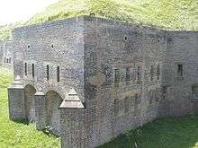
Drop Redoubt
The Drop Redoubt is one of the two forts on Western Heights, and is linked to the other, the Citadel, by a series of dry moats (the lines). It is, arguably, the most impressive and immediately noticeable feature on Dover’s Western Heights.
The artillery at the Redoubt faced mostly inland; it was intended to attack an invading force attempting to capture Dover from the rear.
The construction of the Redoubt was in two periods: the first being from 1804-1808 during the Napoleonic Wars, and the second from 1859-1864 following the recommendations of the 1859 Royal Commission.
First Period
The original form of the Drop Redoubt was a simple pentagon, formed by cutting trenches into the hillside and revetting (facing) them with brickwork. Thus, the Redoubt was a solid ‘island’ with barracks, magazine, and artillery, on top. Originally, it would have accommodated 200 troops but, by 1893, the numbers had been reduced to just 90.
A striking feature of the first period is the Soldiers’ Quarters – five bomb-proof casemates. These are parabolic in cross section and covered in a thick layer of earth to withstand the effect of mortar-bombs. The windows at the rear of each open into a trench, to protect them against blast.
Second Period
The rise of Napoleon III during the 1850s caused a further invasion scare, and a Royal Commission was set up in 1859 to investigate the defences of Britain. As a result, more work was deemed necessary at the Heights, and the Drop Redoubt had its defences improved. Caponiers were added to four of the corners of the existing fort (each with a stone staircase leading up to the top of the Redoubt), and gunrooms were built alongside two of them to allow fire along the North and South-East Lines. The original magazine was enlarged, and covered with a large earth bank as protection from mortar-fire.
The Officers’ Quarters, Guardroom, and cells also date from this period. They can be distinguished from the earlier work by the semi-circular shape of their arches.
During World War II, the Redoubt housed a squad of commandos that, in the event of invasion, would have been responsible for destroying Dover Harbour. Their presence was secret and the lines around the Redoubt were mined. Evidence of their stay are the sally ports in Caponiers 1 & 2, and the short tunnel leading from the encircling line to Drop Redoubt Road.
The entrance to Drop Redoubt was via a bridge. The inner third of this was pivoted so that the Redoubt could be isolated. The pivot and the recess into which the bridge swung can still be seen, although the bridge has long since gone. In the 1980s, a temporary scaffolding bridge was built by the army to enable access for guided tours of the Redoubt, but this was removed in the middle 1990s to prevent unauthorised entry and vandalism.
The Armaments
Originally, the Redoubt was to be equipped with 12 smooth bore 24-pounder guns and two carronades. However, it is unlikely that many were installed since the Napoleonic War was almost over by the time construction was completed. In 1851, only three 24-pounders were in place, with six 12-pounder saluting guns and an 8” mortar.
Following the Second Period, eleven Armstrong 64-pounder Rifled Breech Loaders were installed on traversing carriages. These proved unsatisfactory and a return was made to muzzle loaders.
The Western Pharos
On top of the Redoubt are the remains of a Roman Pharos, or lighthouse, which complemented the one that still exists in the grounds of Dover Castle. Both date from the 2nd Century AD, and would have been similar in design lighting the cliffs either side of the Roman Port of Dubris. The remains were lost during the first period of construction, but were re-discovered during the second period and restored to their original position as a rather shapeless lump of masonry. The foundations, though, are present in the room immediately below.
Local names for the remains of the Pharos are the ‘Bredenstone’ or the ‘Devil’s Drop of Mortar’, and it was here, until 1804, that the Lords Warden of the Cinque Ports had their installation ceremony. It is likely that the name ‘Drop Redoubt’ originates from the local name given to the ruins of the Pharos.
Today
Today, much of the site is open as a country park. The barracks have been demolished; and the Citadel has been a young offenders' institution - and is now Dover Immigration Removal Centre and so is off limits.
English Heritage owns the Redoubt; the Grand Shaft spiral staircase is owned by the council, and is annually opened by the Western Heights Preservation Society.
The Grand Shaft Bowl, located south of Drop Redoubt, is the proposed location for the new National War Memorial, which will commemorate, by name, all of the British Commonwealth casualties of World War I and World War II.
The Grand Shaft Barracks was the location for the filming of the post-nuclear attack scenes in the Peter Watkins 1965 film; The War Game.
Coordinates: 51°07′08″N 1°18′04″E / 51.119014°N 1.301022°E
See also
References
- ↑ "Western Heights". Local Nature Reserves. Natural England. Retrieved 26 July 2013.
- ↑ "Map of Western Heights". Local Nature Reserves. Natural England. Retrieved 26 July 2013.
External links
- Western Heights Preservation Society
- Western Heights - Heritage factsheet - White Cliffs Country
- Historic notes
- Images of the Western Heights
- Proposed National War Memorial
- Photographs of the Detached Bastion on the Western Heights
- Photographs of the drop redoubt on the Western Heights
- Photographs and more details of the Drop Redoubt from CastleList.com
- Visitor information at English Heritage
- Victorian Forts data sheet