Dorion, Ontario
| Dorion | |
|---|---|
| Township (single-tier) | |
| Township of Dorion | |
|
Ouimet Canyon | |
 Dorion | |
| Coordinates: 48°47′N 88°36′W / 48.783°N 88.600°WCoordinates: 48°47′N 88°36′W / 48.783°N 88.600°W | |
| Country |
|
| Province |
|
| District | Thunder Bay |
| Settled | 1893 |
| Incorporated | 1969 |
| Government | |
| • Reeve | Dave Harris |
| • Federal riding | Thunder Bay—Superior North |
| • Prov. riding | Thunder Bay—Superior North |
| Area[1] | |
| • Land | 212.12 km2 (81.90 sq mi) |
| Population (2006)[1] | |
| • Total | 338 |
| • Density | 1.6/km2 (4/sq mi) |
| Time zone | EST (UTC-5) |
| • Summer (DST) | EDT (UTC-4) |
| Postal Code FSA | P0T |
| Area code(s) | 807 (857 exchange) |
| Website | www.doriontownship.ca |
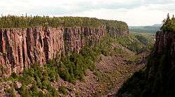
Dorion is a township in the Canadian province of Ontario, located within the Thunder Bay District. The township had a population of 338 in the Canada 2011 Census. Ouimet Canyon and the Dorion Bible Camp are located in the community.
Demographics
| Canada census – Dorion, Ontario community profile | |||
|---|---|---|---|
| 2011 | 2006 | 2001 | |
| Population: | 338 (-10.8% from 2006) | 379 (-14.3% from 2001) | 442 (-6.4% from 1996) |
| Land area: | 212.12 km2 (81.90 sq mi) | 212.07 km2 (81.88 sq mi) | 212.08 km2 (81.88 sq mi) |
| Population density: | 1.6/km2 (4.1/sq mi) | 1.8/km2 (4.7/sq mi) | 2.1/km2 (5.4/sq mi) |
| Median age: | 45.3 (M: 45.3, F: 45.3) | 37.0 (M: 35.9, F: 37.8) | |
| Total private dwellings: | 154 | 188 | 188 |
| Median household income: | $59,195 | $48,141 | |
| References: 2011[1] 2006[2] 2001[3] | |||
Population trend:[4]
- Population in 2006: 379
- Population in 2001: 442
- Population in 1996: 472
- Population in 1991: 513
See also
References
- 1 2 3 "Dorion census profile". 2011 Census of Population. Statistics Canada. Retrieved 2012-03-29.
- ↑ "2006 Community Profiles". Canada 2006 Census. Statistics Canada. March 30, 2011. Retrieved 2011-04-25.
- ↑ "2001 Community Profiles". Canada 2001 Census. Statistics Canada. February 17, 2012. Retrieved 2011-04-25.
- ↑ Statistics Canada: 1996, 2001, 2006 census
 |
Unorganized Thunder Bay (Hurkett) | | ||
| Unorganized Thunder Bay | |
Black Bay (Lake Superior) | ||
| ||||
| | ||||
| Shuniah |
| Cities |  | |
|---|---|---|
| Towns | ||
| Townships | ||
| First Nations |
| |
| Indian reserves |
| |
| Indian settlements | ||
| Unorganized areas | ||
| Local services boards | ||
| Ghost towns | ||
| ||
This article is issued from Wikipedia - version of the 5/27/2015. The text is available under the Creative Commons Attribution/Share Alike but additional terms may apply for the media files.