Donnersbergkreis
| Donnersbergkreis | ||
|---|---|---|
| District | ||
| ||
 | ||
| Country |
| |
| State | Rhineland-Palatinate | |
| Capital | Kirchheimbolanden | |
| Area | ||
| • Total | 645.46 km2 (249.21 sq mi) | |
| Population (31 December 2015)[1] | ||
| • Total | 75,230 | |
| • Density | 120/km2 (300/sq mi) | |
| Time zone | CET (UTC+1) | |
| • Summer (DST) | CEST (UTC+2) | |
| Vehicle registration | KIB | |
| Website | donnersberg.de | |
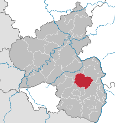
The Donnersbergkreis is a district (Kreis) in the middle of Rhineland-Palatinate, Germany. Neighboring districts are Bad Kreuznach, Alzey-Worms, Bad Dürkheim, Kaiserslautern, Kusel.
History
The district was created in 1969 by merging the districts Kirchheimbolanden and Rockenhausen.
Geography
The district is located around the highest mountain of the Palatinate, the Donnersberg with 687 m above sea level.
Coat of arms
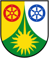 |
Both of the districts merged into the Donnersbergkreis had a wheel in their coat of arms, which are now also shown in the coat of arms of the new district. On the left is the red wheel of the Lords of Bolanden, taken from the Kirchheim coat of arms. The blue wheel on the right is the wheel of the Lords of Falkenstein, taken from the Rockenhausen coat of arms. The green field on the bottom with the peak symbolizes the Donnersberg, the highest elevation in the district, and the sun the importance of the sunny plains for viticulture. |
Towns and municipalities
References
- ↑ "Gemeinden in Deutschland mit Bevölkerung am 31. Dezember 2015" (PDF). Statistisches Bundesamt (in German). 2016.
External links
| Wikimedia Commons has media related to Donnersbergkreis. |
- Official website (German)
- Touristic website (German)
Coordinates: 49°38′N 7°55′E / 49.633°N 7.917°E
This article is issued from Wikipedia - version of the 3/16/2016. The text is available under the Creative Commons Attribution/Share Alike but additional terms may apply for the media files.