Dongluo
| Dongluo 东罗镇 | |
|---|---|
| Town | |
|
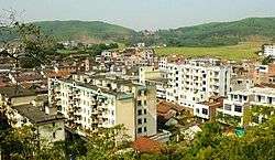
Dongluo town | |
| Coordinates: 22°23′58″N 107°41′06″E / 22.39944°N 107.68500°ECoordinates: 22°23′58″N 107°41′06″E / 22.39944°N 107.68500°E | |
| Country | People's Republic of China |
| Region | Guangxi |
| Prefecture-level city | Chongzuo |
| County | Fusui |
| Village-level divisions | 9 villages |
| Area | |
| • Total | 215.5 km2 (83.2 sq mi) |
| Population (2011) | |
| • Total | 41,000 |
| • Density | 190/km2 (490/sq mi) |
| Time zone | China Standard (UTC+8) |
| Postal code | 532115 |
Dongluo (simplified Chinese: 东罗镇; traditional Chinese: 東罗鎮; pinyin: Dōngluó Zhèn; zhuang: Dunghloz Cin) is a town under the administration of Fusui County in southern Guangxi Zhuang Autonomous Region, China.[1] As of 2011, it had an area of 215.5 square kilometres (83.2 sq mi) populated by 41,000 people residing in 9 villages. 94% of the people belong to the Zhuang ethnic group.[2]
Administrative divisions
There are 9 villages:[3]
Villages:
- Dongluo(东罗村), Kelan(客兰村), Douchong(都充村), Nalian(那练村), Cenfan(岑凡村), Qukan(渠坎村), Bayang(岜羊村), Dongdou(东斗村), Houzhai(厚寨村)
See also
References
- ↑ 2011年统计用区划代码和城乡划分代码:扶绥县 (in Chinese). National Bureau of Statistics of the People's Republic of China. Retrieved 2013-01-08.
- ↑ 2011年统计用区划代码和城乡划分代码:东罗镇 (in Chinese). National Bureau of Statistics of the People's Republic of China. Retrieved 2013-01-03.
- ↑ 2011年统计用区划代码和城乡划分代码:东罗镇 中华人民共和国国家统计局 National Bureau of Statistics of the People's Republic of China. Retrieved 2013-01-02.(Chinese)
External links
This article is issued from Wikipedia - version of the 2/10/2016. The text is available under the Creative Commons Attribution/Share Alike but additional terms may apply for the media files.