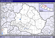
Dolpa District
| Dolpa डोल्पा | |
|---|---|
| District | |
|
| |
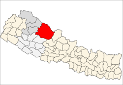 Location of Dolpa | |
| Country | Nepal |
| Region | Mid-Western (Madhya Pashchimanchal) |
| Zone | Karnali |
| Headquarters | Dunai |
| Area | |
| • Total | 7,889 km2 (3,046 sq mi) |
| Population (2011) | |
| • Total | 36,700 |
| • Density | 4.7/km2 (12/sq mi) |
| Time zone | NPT (UTC+5:45) |
| Main language(s) | Nepali |
Dolpa District (Nepali: डोल्पा जिल्ला![]() Listen ), is one of the ten districts of Province No. 6 in Nepal. The district, with Dunai as its district headquarters, covers an area of 7,889 km2 (3,046 sq mi) and has a population (2011) of 36,700.[1]
Listen ), is one of the ten districts of Province No. 6 in Nepal. The district, with Dunai as its district headquarters, covers an area of 7,889 km2 (3,046 sq mi) and has a population (2011) of 36,700.[1]
Geography and Climate
Dolpa is the largest district of Nepal covering 5.36% of the total landmass of the country, located at 28°43’N to 29°43’N latitude, and 82°23’E to 83°41’E longitude. Elevation ranges from 1,525 to 7,625 m (5,003 to 25,016 ft). The district borders Tibet ( China) on the north and northeast, Jumla and Mugu districts of Karnali on the west, Myagdi, Jajarkot and Rukum on the south, and Mustang on the east.
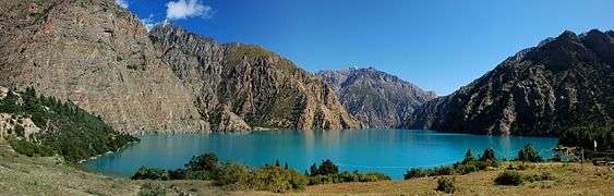
A large portion of the district is protected by Shey Phoksundo National Park. The name is derived from the 12th century Shey Monastery and the deepest lake in Nepal, the Phoksundo Lake, both of which lie in the district. The park protects endangered animals like the snow leopard, musk deer and the Tibetan wolf. Shey Phoksundo is the largest and the only trans-Himalayan National Park in Nepal.
It is also one of the two districts that lie beyond the Himalaya or the trans-Himalaya, Mustang being the other.
The district distances an altitudinal range of over 5,000 m (16,000 ft) from a little over 1,500 m (4,900 ft) at Tribeni in Kalika VDC to 7,381 m (24,216 ft) meters at the peak of Churen Himal. Kanjiroba (6,221 m (20,410 ft)), Mukot (6,638 m (21,778 ft)) and Putha Hiunchuli (7,246 m (23,773 ft)) are other renowned peaks.
Physiographical the smaller ranges of the Great Himalayas comprise the southern border of the district. Between these and the border mountain ranges of Gautam Himal and Kanti Himal to the north, Dolpa district is a labyrinth of often wide glacial valleys and ridges. Kanjiroba Himal and Kagmara Lekh running northwest to southeast separate the valleys of the Jagdula in the west from the rest of the district.
| Climate Zone[2] | Elevation Range | % of Area |
|---|---|---|
| Subtropical | 1,000 to 2,000 meters 3,300 to 6,600 ft. |
0.3% |
| Temperate | 2,000 to 3,000 meters 6,400 to 9,800 ft. |
5.1% |
| Subalpine | 3,000 to 4,000 meters 9,800 to 13,100 ft. |
12.2% |
| Alpine | 4,000 to 5,000 meters 13,100 to 16,400 ft. |
8.2% |
| Nival | above 5,000 meters | 3.8% |
| Trans-Himalayan[3] | 3,000 to 6,400 meters 9,800 to 21,000 ft. |
70.2% |
Demography
Dolpa's population is approximately 29,545. Most of the people are Hindu (60%) or Buddhist (40%). 5.05% belong to the ancient Bonpo religion. Dolpa's major occupations are agriculture (79.5%) and service (2%).
Tourism
Dolpa region is a distant region of Nepal and the central point of this area is Shey Phoksumdo National Park. The east and south of Dolpa are surrounded by the Dhaulagiri and Churen Himal ranges and to the west is the Jumla district. Trekking to Lower Dolpa offers you the remarkable and breathtaking experience of a lifetime. The notable features seen here are snowy peaks, ancient and remote villages, rich wildlife, lovely Buddhist monasteries and wonderful lakes. The people of this area are simple and warm-hearted with an enthralling culture and traditions. The cultural traditions of this area are basically linked with the Tibetan culture.
Trekking into Dolpa presents an exposure to the high and remote Himalayan valleys, resembling the Tibetan highlands. The main highlight of Dolpa trekking includes “Shey Phoksundo National Park” which is one of the major National Parks of Nepal. “Shey Phoksundo Lake” is another famous feature of this region. The lake is totally free of aquatic life, which the crystal waters clearly demonstrate. Surrounded by rocks, forests, and snow-capped peaks, the area has been described as one of the world's “Natural Hidden Wonders”.
The Dolpa trekking starts at Juphal and follows the track to Dunai, then continues to Tarakot, way up to Bang la Camp, the uppermost point of Dolpa trekking. After passing through Sanu Bheri village, we then descend to the good-looking Phoksundo Lake, which is a piece of the Shey Phoksundo National Park.
Transport
This district, despite being the largest in area in the nation, has only 1 vehicle as of November 2012, and no road links to other districts.[5] Government is trying to link roadway to Dolpa,Dunai. The road is linked to Rukum, Jajarkot districts. The road is 118 km long, of which 73 km road construction is completed and is planning to complete up to Asaar.
Towns and villages
See also
Notes and references
- ↑ "National Population and Housing Census 2011(National Report)" (PDF). Central Bureau of Statistics. Government of Nepal. November 2012. Retrieved November 2012. Check date values in:
|access-date=(help) - ↑ The Map of Potential Vegetation of Nepal - a forestry/agroecological/biodiversity classification system (PDF), . Forest & Landscape Development and Environment Series 2-2005 and CFC-TIS Document Series No.110., 2005, ISBN 87-7903-210-9, retrieved Nov 22, 2013
- ↑ Shrestha, Mani R.; Rokaya, Maan B.; Ghimire, Suresh K. (2005). "Vegetation pattern of Trans-Himalayan zone in the North-West Nepal". Nepal Journal of Plant Sciences. 1: 129–135. Retrieved Feb 7, 2014.
- ↑ Banerji, Gargi; Basu, Sejuti. "Climate Change and Himalayan Cold Deserts: Mapping vulnerability and threat to ecology and indigenous livelihoods" (PDF). Pragya. Gurgaon, Haryana, India. Retrieved February 7, 2014.
- ↑ "Few vehicles in Karnali's district - Detail News : Nepal News Portal". The Himalayan Times. 2012-11-30. Retrieved 2014-03-21.
External links
| Wikimedia Commons has media related to Dolpa district. |

Coordinates: 28°56′N 82°54′E / 28.933°N 82.900°E