Dokuzparinsky District
| Dokuzparinsky District Докузпаринский район (Russian) Докъузпара район (Lezgian) | |
|---|---|
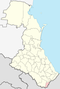 Location of Dokuzparinsky District in the Republic of Dagestan | |
| Coordinates: 41°25′N 47°55′E / 41.417°N 47.917°ECoordinates: 41°25′N 47°55′E / 41.417°N 47.917°E | |
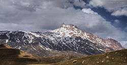 Mount Shalbuzdag in Akhtynsky and Dokuzparinsky Districts | |
 | |
|
| |
| Location | |
| Country | Russia |
| Federal subject | Republic of Dagestan[1] |
| Administrative structure (as of December 2013) | |
| Administrative center | selo of Usukhchay[1] |
| Administrative divisions:[2] | |
| Selsoviets | 2 |
| Inhabited localities:[2] | |
| Rural localities | 16 |
| Municipal structure (as of October 2012) | |
| Municipally incorporated as | Dokuzparinsky Municipal District[3] |
| Municipal divisions:[3] | |
| Urban settlements | 0 |
| Rural settlements | 9 |
| Statistics | |
| Area | 452.1 km2 (174.6 sq mi) |
| Population (2010 Census) | 15,357 inhabitants[4] |
| • Urban | 0% |
| • Rural | 100% |
| Density | 33.97/km2 (88.0/sq mi)[5] |
| Time zone | MSK (UTC+03:00)[6] |
| Official website | |
| Dokuzparinsky District on WikiCommons | |
| 2010 Census | 15,357[4] |
|---|---|
| 2002 Census | 14,330[7] |
Dokuzparinsky District (Russian: Докузпари́нский райо́н; Lezgian: Докъузпара район) is an administrative[1] and municipal[3] district (raion), one of the forty-one in the Republic of Dagestan, Russia. It is located in the south of the republic. The area of the district is 452.1 square kilometers (174.6 sq mi). Its administrative center is the rural locality (a selo) of Usukhchay.[1] As of the 2010 Census, the total population of the district was 15,357, with the population of Usukhchay accounting for 12.2% of that number.[4]
Administrative and municipal status
Within the framework of administrative divisions, Dokuzparinsky District is one of the forty-one in the Republic of Dagestan.[1] The district is divided into two selsoviets which comprise sixteen rural localities.[2] As a municipal division, the district is incorporated as Dokuzparinsky Municipal District.[3] Its two selsoviets are incorporated as nine rural settlements within the municipal district.[3] The selo of Usukhchay serves as the administrative center of both the administrative[1] and municipal[8] district.
References
Notes
- 1 2 3 4 5 6 Law #16
- 1 2 3 Государственный комитет Российской Федерации по статистике. Комитет Российской Федерации по стандартизации, метрологии и сертификации. №ОК 019-95 1 января 1997 г. «Общероссийский классификатор объектов административно-территориального деления. Код 82 221», в ред. изменения №259/2014 от 12 декабря 2014 г.. (State Statistics Committee of the Russian Federation. Committee of the Russian Federation on Standardization, Metrology, and Certification. #OK 019-95 January 1, 1997 Russian Classification of Objects of Administrative Division . Code 82 221, as amended by the Amendment #259/2014 of December 12, 2014. ).
- 1 2 3 4 5 Law #6
- 1 2 3 Russian Federal State Statistics Service (2011). "Всероссийская перепись населения 2010 года. Том 1" [2010 All-Russian Population Census, vol. 1]. Всероссийская перепись населения 2010 года (2010 All-Russia Population Census) (in Russian). Federal State Statistics Service. Retrieved June 29, 2012.
- ↑ The value of density was calculated automatically by dividing the 2010 Census population by the area specified in the infobox. Please note that this value is only approximate as the area specified in the infobox does not necessarily correspond to the area of the entity proper or is reported for the same year as the population.
- ↑ Правительство Российской Федерации. Федеральный закон №107-ФЗ от 3 июня 2011 г. «Об исчислении времени», в ред. Федерального закона №271-ФЗ от 03 июля 2016 г. «О внесении изменений в Федеральный закон "Об исчислении времени"». Вступил в силу по истечении шестидесяти дней после дня официального опубликования (6 августа 2011 г.). Опубликован: "Российская газета", №120, 6 июня 2011 г. (Government of the Russian Federation. Federal Law #107-FZ of June 31, 2011 On Calculating Time, as amended by the Federal Law #271-FZ of July 03, 2016 On Amending Federal Law "On Calculating Time". Effective as of after sixty days following the day of the official publication.).
- ↑ Russian Federal State Statistics Service (May 21, 2004). "Численность населения России, субъектов Российской Федерации в составе федеральных округов, районов, городских поселений, сельских населённых пунктов – районных центров и сельских населённых пунктов с населением 3 тысячи и более человек" [Population of Russia, Its Federal Districts, Federal Subjects, Districts, Urban Localities, Rural Localities—Administrative Centers, and Rural Localities with Population of Over 3,000] (XLS). Всероссийская перепись населения 2002 года [All-Russia Population Census of 2002] (in Russian). Retrieved August 9, 2014.
- ↑ Федеральная служба государственной статистики. Федеральное агентство по технологическому регулированию и метрологии. №ОК 033-2013 1 января 2014 г. «Общероссийский классификатор территорий муниципальных образований. Код 82 621». (Federal State Statistics Service. Federal Agency on Technological Regulation and Metrology. #OK 033-2013 January 1, 2014 Russian Classification of Territories of Municipal Formations. Code 82 621. ).
Sources
- Народное Собрание Республики Дагестан. Закон №16 от 10 апреля 2002 г. «Об административно-территориальном устройстве Республики Дагестан», в ред. Закона №106 от 30 декабря 2013 г. «О внесении изменений в некоторые законодательные акты Республики Дагестан». Вступил в силу со дня официального опубликования. Опубликован: "Дагестанская правда", №81, 12 апреля 2002 г. (People's Assembly of the Republic of Dagestan. Law #16 of April 10, 2002 On the Administrative-Territorial Structure of the Republic of Dagestan, as amended by the Law #106 of December 30, 2013 On Amending Various Legislative Acts of the Republic of Dagestan. Effective as of the day of the official publication.).
- Народное Собрание Республики Дагестан. Закон №6 от 13 января 2005 г. «О статусе и границах муниципальных образований Республики Дагестан», в ред. Закона №43 от 30 апреля 2015 г. «О статусе городского округа с внутригородским делением "Город Махачкала", статусе и границах внутригородских районов в составе городского округа с внутригородским делением "Город Махачкала" и о внесении изменений в отдельные законодательные акты Республики Дагестан». Вступил в силу со дня официального опубликования. Опубликован: "Дагестанская правда", №8, 15 февраля 2005 г. (People's Assembly of the Republic of Dagestan. Law #6 of January 13, 2005 On the Status and Borders of the Municipal Formations of the Republic of Dagestan, as amended by the Law #43 of April 30, 2015 On the Status of the "City of Makhachkala" Urban Okrug with Intra-Urban Divisions, the Status and the Borders of the Intra-City Districts Comprising the "City of Makhachkala" Urban Okrug with Intra-Urban Divisions, and on Amending Various Legislative Acts of the Republic of Dagestan. Effective as of the day of the official publication.).