Dobongsan
| Dobongsan | |
|---|---|
|
Mount Dobongsan peaks Seoninbong (708 m), Manjangbong (718 m), Jaunbong (740 m) and Shinseondae (730 m) taken from trail leading to summit.
 Dobongsan Location | |
| Highest point | |
| Elevation | 739.5 m (2,426 ft) |
| Coordinates | 37°41′54.73″N 127°0′53.88″E / 37.6985361°N 127.0149667°ECoordinates: 37°41′54.73″N 127°0′53.88″E / 37.6985361°N 127.0149667°E |
| Geography | |
| Location | South Korea |
| Climbing | |
| Easiest route | Dobongsan Station |
%2C_Manjangbong_(718m)%2C_Jaunbong_(740m)_and_Shinseondae_(730m).JPG)
| Korean name | |
| Hangul | 도봉산 |
|---|---|
| Hanja | 道峰山 |
| Revised Romanization | Dobongsan |
| McCune–Reischauer | Tobongsan |
Dobongsan is a mountain in Bukhansan National Park, South Korea.[1] It extends across Seoul, the national capital, and the cities of Yangju and Uijeongbu, in the province of Gyeonggi-do.[2] It has an elevation of 739.5 m (2,426 ft).[3] Nearby Dobongsan Station is named after it.[4]
Gallery
 East face of Seoninbong Peak, Dobongsan taken from the trail leading to Manworam Temple.
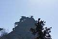 Observation area on a peak of Dobongsan.
 Rugged trail leading to peak of Dobongsan.
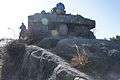 Wartime bunker on Dobongsan summit trail in Korea.
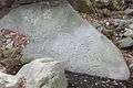 Petroglyph in stream bed at the foot of Dobongsan.
 Temple on Dobongsan
See also
References
| Wikimedia Commons has media related to Dobongsan. |
- ↑ "Dobongsan Mountain". Visit Korea. Korea Tourism Organization. Retrieved 2015-09-16.
- ↑ "Bukhansan Dulle-gil Trail". Visit Korea. Korea Tourism Organization. Retrieved 2015-09-16.
- ↑ Yu Jeong-yeol (2007). 한국의 산 여행 (Travel Guide to Korean Mountains). Seoul: 관동 상억연구회 (Kwandong). p. 47. ISBN 978-89-958055-1-0.
- ↑ "도봉산역" (in Korean). KRIC. Retrieved 2015-09-16.
This article is issued from Wikipedia - version of the 9/16/2015. The text is available under the Creative Commons Attribution/Share Alike but additional terms may apply for the media files.