Dobong District
| Dobong 도봉구 | |
|---|---|
| Autonomous District | |
| 도봉구 · 道峰區 | |
|
Skyline of Dobong District (left side) | |
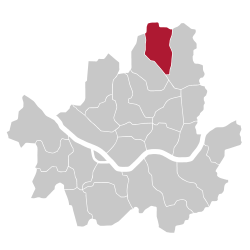 Location of Dobong-gu in Seoul | |
| Coordinates: 37°41′42″N 127°02′49″E / 37.69500°N 127.04694°ECoordinates: 37°41′42″N 127°02′49″E / 37.69500°N 127.04694°E | |
| Country | South Korea |
| Region | Sudogwon |
| Special City | Seoul |
| Administrative dong | 14 |
| Government | |
| • Mayor | Lee dong-jin (이동진) |
| Area | |
| • Total | 20.8 km2 (8.0 sq mi) |
| Population (2010[1]) | |
| • Total | 348,625 |
| • Density | 17,000/km2 (43,000/sq mi) |
| Time zone | Korea Standard Time (UTC+9) |
| Postal code | 01300~01599 |
| Area code | 02-9xx,2000~ |
| Website | Dobong-gu official website |

Dobong District (Dobong-gu) is one of the 25 districts (gu) of Seoul, South Korea. It is located on the north side of the Han River.
Symbols
Mountain
Dobongsan Mountain is a mountain in Bukhansan National Park, partly under the jurisdiction of Dobong-gu. It is a popular leisure spot for district residents.
In addition, Dobongsan Mountain has many large and small temples such as Cheonchuksa, Wontongsa, and Manweolam.[2]
Administrative divisions
Main article: Administrative divisions of Dobong District
Administrative divisions
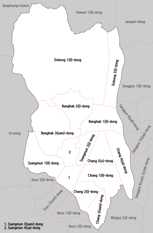
Dobong-gu is composed of four dong.
- Dobong-dong (도봉동 道峰洞) 1, 2
- Banghak-dong (방학동 放鶴洞) 1, 2, 3
- Ssangmun-dong (쌍문동 雙門洞) 1, 2, 3, 4
- Chang-dong (창동 倉洞) 1, 2, 3, 4, 5
Transportation
Railroad
- Korail
- Seoul Metro
- Seoul Subway Line 4
- (Nowon-gu) ← Chang-dong — Ssangmun → (Gangbuk-gu)
- Seoul Subway Line 4
- Seoul Metropolitan Rapid Transit Corporation
Sister cities
References
External links
| Wikimedia Commons has media related to Dobong-gu, Seoul. |
- Map from the Dobong-gu website (Korean)

This article is issued from Wikipedia - version of the 3/4/2016. The text is available under the Creative Commons Attribution/Share Alike but additional terms may apply for the media files.