Dillingham Airport
| Dillingham Airport | |||||||||||
|---|---|---|---|---|---|---|---|---|---|---|---|
 | |||||||||||
| IATA: DLG – ICAO: PADL – FAA LID: DLG | |||||||||||
| Summary | |||||||||||
| Airport type | Public | ||||||||||
| Owner | State of Alaska DOT&PF - Central Region | ||||||||||
| Serves | Dillingham, Alaska | ||||||||||
| Hub for | PenAir | ||||||||||
| Elevation AMSL | 81 ft / 25 m | ||||||||||
| Coordinates | 59°02′41″N 158°30′20″W / 59.04472°N 158.50556°WCoordinates: 59°02′41″N 158°30′20″W / 59.04472°N 158.50556°W | ||||||||||
| Map | |||||||||||
 DLG Location of airport in Alaska | |||||||||||
| Runways | |||||||||||
| |||||||||||
| Statistics (2011) | |||||||||||
| |||||||||||
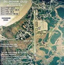
Dillingham Airport (IATA: DLG, ICAO: PADL, FAA LID: DLG) is a state owned, public use airport located two nautical miles (4 km) west of the central business district of Dillingham,[1] a city in the Dillingham Census Area of the U.S. state of Alaska. Scheduled passenger service is available at this airport.
As per Federal Aviation Administration records, the airport had 32,215 passenger boardings (enplanements) in calendar year 2008,[2] 29,374 enplanements in 2009, and 42,927 in 2010.[3] It is included in the National Plan of Integrated Airport Systems for 2011–2015, which categorized it as a primary commercial service airport (more than 10,000 enplanements per year).[4]
Facilities and aircraft
Dillingham Airport covers an area of 620 acres (251 ha) at an elevation of 81 feet (25 m) above mean sea level. It has one runway designated 1/19 with an asphalt surface measuring 6,400 by 150 feet (1,951 x 46 m).[1]
For the 12-month period ending August 31, 2011, the airport had 50,892 aircraft operations, an average of 139 per day: 72% air taxi, 26% general aviation, and 3% scheduled commercial. At that time there were 53 aircraft based at this airport: 98% single-engine and 2% helicopter.[1]
Airlines and destinations
The following airlines offer scheduled passenger service at this airport:
| Airlines | Destinations |
|---|---|
| Alaska Airlines | Anchorage |
| Grant Aviation | King Salmon |
| PenAir | Anchorage, Ekwok, King Salmon, Koliganek, Manokotak, New Stuyahok, Togiak, Twin Hills [5][6] |
See also
- Shannons Pond Seaplane Base, located 3 miles (4.8 km) west of Dillingham Airport.
References
- 1 2 3 4 FAA Airport Master Record for DLG (Form 5010 PDF). Federal Aviation Administration. Effective April 5, 2012.
- ↑ "Enplanements for CY 2008" (PDF, 1.0 MB). CY 2008 Passenger Boarding and All-Cargo Data. Federal Aviation Administration. December 18, 2009. External link in
|work=(help) - ↑ "Enplanements for CY 2010" (PDF, 189 KB). CY 2010 Passenger Boarding and All-Cargo Data. Federal Aviation Administration. October 4, 2011. External link in
|work=(help) - ↑ "2011–2015 NPIAS Report, Appendix A" (PDF, 2.03 MB). National Plan of Integrated Airport Systems. Federal Aviation Administration. October 4, 2010. External link in
|work=(help) - ↑ "Mainline Schedule" (PDF). PenAir. February 29, 2012. Retrieved June 16, 2012.
- ↑ "Timetable" (PDF). PenAir. October 21, 2011. Retrieved June 16, 2012.
External links
- FAA Alaska airport diagram (GIF)
- FAA Terminal Procedures for DLG, effective November 10, 2016
- Topographic map from USGS The National Map
- Resources for this airport:
- FAA airport information for DLG
- AirNav airport information for PADL
- ASN accident history for DLG
- FlightAware airport information and live flight tracker
- NOAA/NWS latest weather observations for PADL
- SkyVector aeronautical chart for DLG