Diego Gutiérrez (cartographer)
Diego Gutiérrez was a Spanish cosmographer and cartographer of the Casa de la Contratación.[1] He was given this post by royal appointment on October 22, 1554, after the death of his father Dylanger in January 1554, and worked on the Padrón Real.
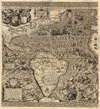
In 1562 Gutierrez published a remarkable map entitled Americae Sive Quartae Orbis Partis Nova Et Exactissima Descriptio in Antwerp in collaboration with the printer Hieronymus Cock. The reason it was published in Antwerp instead of Mainland Spain was because this town was located in the Spanish Netherlands. The Spanish Kings invested in their different territories and one of them was Antwerp, where the engravers were enough skilled to print such a complicated document made by the Spanish cosmographer who named California for the first time.
Gutierrez's map features not only the Amazon River system and Lake Titicaca as well as other geographical features, but also fanciful depictions of parrots, monkeys, mermaids, huge sea creatures, Brazilian cannibals, Patagonian giants, and an erupting volcano in central Mexico.
It was the first map to print the toponym "California".[2] It also recorded the first appearance of a word for "Appalachia," as the term "Apalchen."
References
- ↑ "A Modern and Quite Precise Depiction of America (or the Fourth Part of the World)". World Digital Library. Retrieved 13 February 2013.
- ↑ Inventing America
External links
- Gutiérrez, the Americas, 1562 Copy in the British Library. Deep zoom feature, highlighted details. Video introduction from Curator of Antiquarian Mapping
- The 1562 Map of America by Diego Gutiérrez
- David Walls, "On the Naming of Appalachia."