Dhulikhel
| Dhulikhel धुलिखेल Shikhalapur | |
|---|---|
|
Municipality/ Town Hill station | |
|
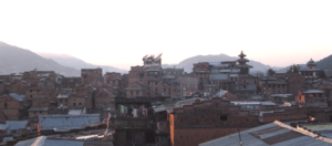
Dhulikhel skyline | |
 Dhulikhel Location in Nepal | |
| Coordinates: 27°37′N 85°33′E / 27.617°N 85.550°ECoordinates: 27°37′N 85°33′E / 27.617°N 85.550°E | |
| Country | Nepal |
| Zone | Bagmati Zone |
| District | Kavrepalanchowk District |
| Population (2011) | |
| • Total | 16,263 |
| Time zone | NST (UTC+5:45) |
| Postal code | 45200 |
| Area code(s) | 011 |
| Website | www.mundhulikhel.gov.np |

Dhulikhel is the administrative centre of Kavrepalanchowk District, Nepal. At the time of the 2011 Nepal census it had a population of 16,263 people in 3,291 households. Two major highway B.P. Highway and Arniko Highway passes through Dhulikhel. Araniko Highway connects Kathmandu, Nepal's capital city with Tibet's border town of Kodari. Dhulikhel is located at the Eastern rim of Kathmandu Valley, south of the Himalayas at 1550m above sea level and is situated 30 km southeast of Kathmandu and 74 km southwest of Kodari. The people in the village are Newars, Brahmin, Chhettri, Tamang and Dalit. Drinking water in Dhulikhel is some of the best water in Nepal. It was made with the Help of the German NGO, German Technical Cooperation.
Tourism
Dhulikhel has been for centuries an important trading centre on the commercial route linking Nepal to Tibet. Since time immemorial, people of Nepal travel to Tibet to bring home salt and gold. Likewise, the Tibetans every year with their flocks of sheep enter into Nepal during Dashain, the greatest Hindu festival. They use to purchase chilies and other daily necessities in Nepal and return to their homeland. In those days, a whole day walk from Kathmandu to Dhulikhel was comfortable for Tibet trippers with easily available of food and water at Dhulikhel at the evening for overnight stay. After adjoining with Tibet by motorable road in 1965, Dhulikhel got a face lift and developed as a tourist destination. Dhulikhel is an ideal station to stop for overnight stay while going to Tibet and coming back to Kathmandu.
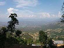
The Mountains The snowfed mountains seen from Dhuklikhel are a fine panoramic. When a blue haze covers the lower portion of the mountains, they seem to be floating in the air. Green inviting hills of which still virgin and some turned into beautifully carved agricultural terraces cater to the beholders' pleasure.


Geographically, the plains rise gradually up to the green mountains and further into the snow-capped Himalayas. The panorama offers a view of the Himalayan ranges stretching from Mount Annapurna in the far west to Mount Karolung in the Far East. More than twenty Himalayan peaks including Mt. Annapurna (8091 m), Mt. Ganesh Himal (7429 m), Mt. Langtang (7234 m), Mt. Phuribichyachu (6637 m), Mt. Gaurishanker (7134 m), Mt. Lhotse (8516 m) and many others can be seen from Dhulikhel.
The Old Town:
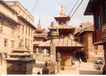
The oldest area of the town, the southern end, is an assembly of old Newari houses, often occupied by 20 or more members of the local extended families. Their most valuable assets are the beautifully carved windows and doors, fine examples of traditional Newari craftsmanship.
The narrow streets, are typical of a medieval city inhabited for at least five centuries. The plan of the city is based on ancient Hindu planning doctrine with the position, shape, scale & dominance between buildings, temples, public squares all having their own meaning and harmony. There are organically developed compact settlements around Dhulikhel. One of such old settlements is Shreekhandpur, which lies 2 km west of the core city near the Kathmandu University, and is also a centuries-old Newari and Magar settlement. The settlement is protected by Swet Bhairav (an incarnation of Lord Shiva) and Narayan (Vishnu) deties. Gorkhanath temple also lies here.
Temples: There are numerous temples in the town depicting traditional and old Newari craftsmanship. These are places of worship for local people. The core area of Dhulikhel has interesting narrow cobbled streets and lanes embedded with number of Hindu Shrines and a few Buddhist Stupa.
In the centre of the old town is the Narayan Temple with its yellow metal roofs. It is dedicated to Lord Krishna whose birthday is celebrated in August. Alongside is the Harisiddhi Temple. Both the temples are adorned with profuese wood carvings and fronted by two Garudas. Bhagwati Temple is situated at the top of the western part of the town. The GaukhureshworMahadev Temple is on the east of the town near Tundikhel Recreation Park. Further up hill, is located the Bhagwati (Kali) Temple, which is a pagoda.
Media
To promote local culture Dhulikhel has one FM radio station Radio Madhyapurba F.M. – 104 MHz Which is a Community radio Station.
See also
- Dhulikhel Municipality
- Dhulikhel Hospital
- Kathmandu University
- Kathmandu University High School
- Kathmandu University Medical School