Dholpur
| Dholpur धौलपुर Dhaulpur | |
|---|---|
| city | |
|
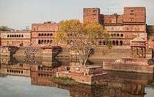
Chhatri of Rana Udaybhanu Singh at Dholpur | |
| Nickname(s): dang | |
 Dholpur Location in Rajasthan, India | |
| Coordinates: 26°42′N 77°54′E / 26.7°N 77.9°ECoordinates: 26°42′N 77°54′E / 26.7°N 77.9°E | |
| Country |
|
| State | Rajasthan |
| Founded by | Dhaval Dev in 11th century |
| Area | |
| • city | 3,034 km2 (1,171 sq mi) |
| Elevation | 177 m (581 ft) |
| Population (2011)[1] | |
| • city | 126,142 |
| • Density | 42/km2 (110/sq mi) |
| • Metro[2] | 133,229 |
| Languages | |
| • Official | Hindi |
| Time zone | IST (UTC+5:30) |
| PIN | 328001 |
| Telephone code | 05642 |
| Vehicle registration | RJ 11 |
| Sex ratio | 862 ♂/♀ |
| Website |
dholpur |


Dholpur is a city in eastern-most parts of the Rajasthan state of India. It is the administrative headquarters of Dholpur District and was formerly seat of the Dholpur princely state, before Independence.
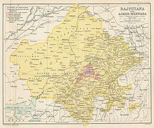
Dhaulpur became a separate district in 1982 comprising four tehsils of Bharatpur: Dholpur, Rajakhera, Bari and Baseri. It is bordered by Bharatpur district of Rajasthan and Uttar Pradesh to the north, Madhya Pradesh to the south, Karauli district to the west and Uttar Pradesh and Madhya Pradesh to the east.
Geography
The geographical coordinates for Dholpur (Dhaulpur) are 26° 42' 0" North, 77° 54' 0" East.[3] Total area of Dholpur district is 3,034 sq. kilometers.[4]
History
During the Buddha's period
During Buddha’s time there were sixteen Mahajanapadas in Bharatvarsh. Dholpur at that time was included in Matsya Janpad. During the Mauryan rule it was included in the Mauryan Empire. From Gupta period to the arrival of Chinese traveler Huansuang Bharatpur, Karauli and Dholpur were a part of Mathura Janpad. Around the 8th to 10th centuries, Chauhans ruled over it. In the year 1194 it remained under Mohammed Gauri.
Tomar rule
Dholpur or Dhawalpuri was established in 700 AD by Raja Dholan Dev Tomar and most likely the name of city was changed to Dholpur after him. He resided 10 km south west of Dholpur at a place called Bilpur near chambal where a fort still exists.[5] His descendant Raja Dhawal Deo built the new town of Dholpur in 1050 AD. Their descendants are still living in the area and till independence were rulers of many small chieftainships in Morena and Gwalior. He was ruler of country between Chambal and Banganga. The Dholeshwar Mahadev Temple built by this Raja was washed away in Chambal floods of 1868 AD.[6] The Tomars lost sovereignty to Jadu's of Karauli.
Yadava rulers of Karauli
The Dholpur fort was built by Dharampal, Raja of Karauli in 1120 A.D.[6]
During Delhi sultans
Any invader, who wished to capture Gwalior and Malwa, had to pass through Dholpur. In the year 1489 Bahlol Lodi before fighting with Gwalior king, faced the forces of the ruler of Dholpur. During the year 1502 Sikandar Lodi had to fight with Dholpur King Vinayak Dev for about a year and then with great difficulty was successful in defeating him and capturing Dholpur. Thus Dholpur came into prominence and bore the brunt of all the invading forces of the North Realising the strategic and geographical importance. It was Sikandar Lodi who first thought of having a military cantonment at Agra which was a small village under Bayana and at Dholpur in the year 1504, so that he could successfully carry out military designs against Gwalior and Malwa region. Dholpur being situated on the banks of the river Chambal was considered sate for the establishment of military cantonment and forts, during the medieval period. According to the "Tawarikh Shershahi" and "Babarnama" written by their courtiers, the credit for the construction of the Shergarh for goes to Shershah Suri.
Mughal period
After the battle of Panipat, Babar became the first Mughal ruler of Hindustan. His rule was not a bed of roses in the early years of his reign. After the death of Ibrahim Lodi, many states declared themselves independent. Talai Khan became the ruler of Gwalior. Similarly, Mohammed Jaifoon declared himself the ruler of Dholpur. Babar sent Junniad Barlas to Dholpur, who crushed the rebellion and took over the administration of Dholpur in his own hands.
Dholpur was known for its natural beauty, dense forests and ample games that attracted the royal princes regularly visiting this region during Mughal period. According to Humayunnama, Babar once took all his wives and consorts to Dholpur on the death of his son Anwar Mirza for a change. The beauty of Dholpur fascinated Akbar so much that he constructed the palaces at Khanpur on the banks of Talab-shahi near Bari. According to legends he constructed these palaces to make this place his capital. Later, on being offended by the residents, he left them and founded Fatehpur Sikri. The incident which paved the way for Aurangzab's stability occurred at the place which sealed that fate of Dara Shikoh.
Once Dholpur became a matter of dispute between Shahjahan and Nur Jahan. Shahjahan requested Emperor Jehangir to give him the pargana of Dholpur. Shahjahan, taking it for granted that the Emperor would give his consent, sent his faithful officer to Dholpur. On the other hand, Nur Jahan had already acquired the Paragana of Dholpur for prince Shahryar. She deputed Sharif-ul-Malik to take charge of the administration. There was a clash between the two, in which Sharif-ul-Malik had an eye injury and many people died.[7] For this act of insolence Shahjahan was reprimanded and was asked to send his troops from the south to Agra immediately.
Gurjar rule
After the death of Aurangzeb, Raja Kalyan Singh Gurjar occupied the fort till 1761 AD, whence Raja of Bharatpur, the Jat ruler Maharaja Surajmal took control of the fort.[6]
Bamraulia rulers
In Second Anglo-Maratha War between the British and Marathas at Laswari on 1 November 1803, Lord Lake defeated Sindhia and vanished his reputation.[8][9] In this war the Jats helped the British. The British army officers had affection for Jats.[9]
Later the British concluded a treaty with the Jats and with their help defeated Marathas and won back Gwalior and Gohad from them. The British kept Gwalior with them but returned Gohad to the Jats in 1804.[10] Gohad was handed over to Marathas under a revised treaty dated 22 November 1805 between Marathas and British. Under the treaty Gohad ruler Rana Kirat Singh was given Dhaulpur, Badi and Rajakheda in exchange. Rana Kirat Singh moved to Dhaulpur in December 1805.[11] Sindhias were able to take over Gohad on 27 February 1806 with the help of the British. Thus the Rana Jat rulers of Bamraulia gotra ruled Gohad for 300 years from 1505–1805 and after that their rule was transferred at Dholpur.[12]
British rule and after
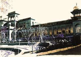
After Mughals Rana vansh of Jats become ruler of Dhaulpur, during British Raj, it was part of the Rajputana Agency, till the Independence of India. The former mansion of the ruler of the erstwhile Dholpur State, Kesarbagh palace, now houses the Dholpur Military School, while its official residence in New Delhi, Dholpur House, is used by the Union Public Service Commission.
Tourism and landmarks

The prime tourist attractions in Dholpur are:
- Nihal tower: Rana Ram Singh of Dholpur was the Jat ruler of the princely state Dholpur (1901–1911) in Rajasthan, India. He was from Bamraulia gotra of Jats. He was born on 26 May 1883 and succeeded Rana Nihal Singh in 1901 after his death. Rana Nihal Singh was not of age when ascended to the throne. He got full rights in March 1905. Nihal Singh constructed Nihal tower. His successor was Rana Udaybhanu Singh.
- The Machkund Temple: Muchchhkund is about 4 km from the town of Dholpur. It is an ancient sacred place. It commands a picturesque view. The place is named after Raja Muchchhukand, the 24th of the Suryavanshi Dynasty (the solar race) who is said to have reigned nineteen generations before Lord Ram. According to legend, Raja Muchchhkund was sleeping here when demon Kaal Yaman (while pursuing lord Krishna) accidentally woke him up. The demon Kaal Yaman was burnt to ashes because of a divine blessing to Raja Muchchhkund. It is now a sacred place for pilgrims.
- Chopra Shiv Temple: This temple was built in the 18th century. It is the oldest Shiv Temple in Dholpur. In the month of march on the occasion of Mahashiv Ratri this temple is full of pilgrims and devotees of lord Shiv. On Mondays much crowd come here to pay their offerings and prayers because Monday is considered as a day of lord Shiv according to the Hindu mythology. It is just 1/2 km from Dholpur new Bus stand so is at just a stone’s throw distance from bus stand and you can also hire a rickshaw to reach the temple. This ancient temple boasts of great architectural beauty.
- Sant Nagar: Sant Nagar, a Buddha temple is 2 km from Bari.
- Sher Shikar Gurudwara: a Sikh pilgrimage site in Machkund, Dholpur, associated with the history of sixth Sikh Guru Hargobind Sahib ji.
- Shergarh Fort: It is an old fort of historic importance, located toward the south of Dholpur tower. This monument was built by Sher Shah Suri on the site of an earlier Hindu fortress.
Economy
The economy of Dhaulpur is primarily agricultural. Dholpur sandstone is mined in the area, which is simply called "Dholpur", and was used in the construction of Rashtrapati Bhavan and Secretariat Building, New Delhi in the 1920s.[13] A gas-based thermal power plant of 330 Megawatt capacity has started working in Dholpur.
Dholpur Combined Power Station is located in Dholpur City and is situated above 7 km from district headquarters on the bari road near Chawani. Based on gas this project is compatively safe in view of environment and water pollution. A 70 Meter high stack has been provided to release fuel gases into the atmosphere so as to disperse the emitted matter over a widespread area. This is a project of Rajasthan Rajya Vidyut Utpadan Nigam Ltd. The installed capacity of three units of Dholpur Combined Power Station is 330MW.
Environment
- Damoye: A waterfall in Sarmathura. It is the main tourist spot in whole district. It is visible in rainy season [July–September]. Besides this, Damoye has a long and green forest range with wild animals.

- Talab-e-Shahi: 27 kilometres from Dholpur (and 5 kilometers from Bari) is a picturesque lake called Talab Shahi. The lake and the palace were built in 1617 A.D. as a shooting lodge for Prince Shah Jahan. The palace and the lake were later maintained by the ruler of Dholpur. The lake attracts a large number of winter migratory fowl such as pintail, shoveller, red crested pochard, common pochard, tufted duck, garganey teal, wigeon and fadwall.
- Ravines of Chambal: The Ravines of Chambal derives its name from Chambal River, has been a safe haven for gangs of dacoits for a number of decades. The Chambal ravine or 'beehad' (Hindi-बीहड़) has harbored dacoits (bandits) for centuries. One of the famous dacoits was Phoolan Devi, Lokman Dikshit, Man Singh & fakkad Baba who terrorised the entire Chambal valley. It is also known as the " Veer Bhoomi Chambal ".
- Ramsagar Sanctuary :Contains picturesque Ramsagar Lake, which supports rich aquatic life including fresh water crocodiles and a number of fishes and snakes. Water birds such as cormorants, white-breasted water hen, moor hen, jacanas, river tern, ringed plover, sand piper, and green and purple herons are quite common. During winter months migratory ducks and geese visit the lake in good numbers.
- Van Vihar Wild Life Sanctuary: Van Vihar, an old wildlife reserve of the rulers of Dholpur is spread over an area of 59.86 km2 over Vindhyan Plateau.
- National Chambal (Gharial) Wildlife Sanctuary: The Chambal river remains one of north India's most unpolluted rivers, home to a rich diversity of flora and fauna. National Chambal (Gharial) Wildlife Sanctuary contains the rare Ganges river dolphin. The sanctuary was founded in 1978 and is part of a large area co-administered by Rajasthan, Madhya Pradesh and Uttar Pradesh, within area of 5,400 km². Approximately 400 km of the river is within the reserve. Apart from the Ganges river dolphin, the other inhabitants of the sanctuary include mugger crocodiles and gharial (Gavialis gangeticus). Migratory birds from Siberia form its rich avian fauna.
Demographics
As of the 2011 census, Dhaulpur municipality had a population of 126,142[1] and the urban agglomeration had a population of 133,229.[2] The municipality had a sex ratio of 862 females per 1,000 males and 13.6% of the population were under six years old.[1] Effective literacy was 76.56%; male literacy was 84.22% and female literacy was 67.74%.[1]
Education
The notable Dholpur Military School is housed in Kesarbagh Palace, a magnificent mansion of the former ruler of the erstwhile Dholpur State. It is 10.5 kilometres away from Dholpur City and on Dholpur-Bari Road.
Climate
Dholpur is reputed to be the location of the highest recorded temperature in India, at 50 °C on June 3, 1995. The hottest months are May and June, which mark the oppressive summer season. Temperatures in summers are normally higher than 40 °C. Coldest months are December and January where temperatures sometimes reach near-zero and subzero levels. The lowest recorded temperature is -4.3 °C on January 29, 1990.[14]
| Climate data for Dholpur | |||||||||||||
|---|---|---|---|---|---|---|---|---|---|---|---|---|---|
| Month | Jan | Feb | Mar | Apr | May | Jun | Jul | Aug | Sep | Oct | Nov | Dec | Year |
| Record high °C (°F) | 32.6 (90.7) |
36.8 (98.2) |
42.8 (109) |
47.3 (117.1) |
49.8 (121.6) |
50.0 (122) |
46.0 (114.8) |
42.2 (108) |
41.7 (107.1) |
41.8 (107.2) |
37.7 (99.9) |
32.6 (90.7) |
50.0 (122) |
| Record low °C (°F) | −4.3 (24.3) |
0.2 (32.4) |
4.0 (39.2) |
11.0 (51.8) |
16.7 (62.1) |
18.4 (65.1) |
20.9 (69.6) |
17.4 (63.3) |
14.9 (58.8) |
8.9 (48) |
3.1 (37.6) |
−3.3 (26.1) |
−4.3 (24.3) |
| Source: India Meteorological Department[15] | |||||||||||||
References
- 1 2 3 4 "Provisional Population Totals, Census of India 2011; Cities having population 1 lakh and above" (pdf). Office of the Registrar General & Census Commissioner, India. Retrieved 27 March 2012.
- 1 2 "Provisional Population Totals, Census of India 2011; Urban Agglomerations/Cities having population 1 lakh and above" (pdf). Office of the Registrar General & Census Commissioner, India. Retrieved 27 March 2012.
- ↑ Google. "maplandia.com". Google. Retrieved 10 October 2014.
- ↑ "Introduction".
- ↑ John Murray (Firm), Edward Backhouse Eastwick -Handbook of the Bengal Presidency, page 370
- 1 2 3 John Murray (Firm), Edward Backhouse Eastwick - Handbook of the Bengal Presidency, page 370
- ↑ Dholpur The Riyazu-s-Salatin (Gardens of the Sultans), a History of Bengal, by Ghulam Husain Salim 'Zayadpuri'. 1787-8.
- ↑ GS Desai:Marathon kaavin Itihas,partIII,p.446-47
- 1 2 Dr. Ajay Kumar Agnihotri (1985) : "Gohad ke jaton ka Itihas" (Hindi), p.62
- ↑ Dr. Ajay Kumar Agnihotri (1985) : "Gohad ke jaton ka Itihas" (Hindi), p.63
- ↑ Dr. Ajay Kumar Agnihotri (1985) : "Gohad ke jaton ka Itihas" (Hindi), p.71
- ↑ Dr. Ajay Kumar Agnihotri (1985) : "Gohad ke jaton ka Itihas" (Hindi)
- ↑ "The building Blocks of British empire". Hindustan Times. June 7, 2011.
- ↑ "Ever recorded Maximum and minimum temperatures upto 2010". India Meteorological Department. Archived from the original on May 21, 2013. Retrieved 2013-05-21.
- ↑ "Ever recorded Maximum and minimum temperatures upto 2010" (PDF). India Meteorological Department. Retrieved 2013-05-21.
External links
| Wikimedia Commons has media related to Dholpur. |
| Outline | 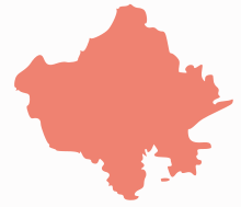 | ||||||||||||||||||||||||||
|---|---|---|---|---|---|---|---|---|---|---|---|---|---|---|---|---|---|---|---|---|---|---|---|---|---|---|---|
| Governance | |||||||||||||||||||||||||||
| Divisions and Districts |
| ||||||||||||||||||||||||||
| Major cities | |||||||||||||||||||||||||||
| Related templates |
| ||||||||||||||||||||||||||