Dhaulagiri
| Dhaulagiri | |
|---|---|
 | |
| Highest point | |
| Elevation |
8,167 m (26,795 ft) Ranked 7th |
| Prominence |
3,357 m (11,014 ft) [1] Ranked 55th |
| Isolation | 318 kilometres (198 mi) |
| Parent peak | K2 [2] |
| Listing |
Eight-thousander Ultra |
| Coordinates | 28°41′54″N 83°29′15″E / 28.69833°N 83.48750°ECoordinates: 28°41′54″N 83°29′15″E / 28.69833°N 83.48750°E |
| Geography | |
 Dhaulagiri | |
| Parent range | Dhaulagiri Himal |
| Climbing | |
| First ascent |
May 13, 1960 by Kurt Diemberger, A. Schelbert, E. Forrer, Nawang Dorje, Nyima Dorje (First winter ascent 21 January 1985 Jerzy Kukuczka and Andrzej Czok) |
| Easiest route | Northeast ridge |
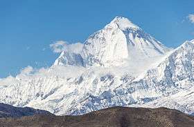
The Dhaulagiri massif in Nepal extends 120 km (70 mi) from the Kaligandaki River west to the Bheri. This massif is bounded on the north and southwest by tributaries of the Bheri River and on the southeast by Myagdi Khola. Dhaulagiri I is the seventh highest mountain in the world at 8,167 metres (26,795 ft) above sea level. It was first climbed on May 13, 1960 by a Swiss/Austrian/Nepali expedition.
The mountain's name is धौलागिरी (dhaulāgirī) in Nepali. This comes from Sanskrit where धवल (dhawala) means dazzling, white, beautiful[3] and गिरि (giri) means mountain.[4] Dhaulagiri I is also the highest point of the Gandaki river basin.
Annapurna I (8,091m/26,545 ft) is 34 km. east of Dhaulagiri I. The Kali Gandaki River flows between the two in the Kaligandaki Gorge, said to be the world's deepest. The town of Pokhara is south of the Annapurnas, an important regional center and the gateway for climbers and trekkers visiting both ranges as well as a tourist destination in its own right.
Geography

Looking north from the plains of India, most 8,000-metre peaks are obscured by nearer mountains, but in clear weather Dhaulagiri I is conspicuous from northern Bihar[5] and as far south as Gorakhpur in Uttar Pradesh. In 1808 A.D. survey computations showed it to be the highest mountain yet surveyed.[6][7] This lasted until 1838 when Kangchenjunga took its place, followed by Mount Everest in 1858.
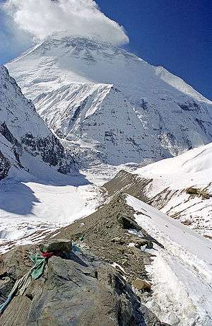
Dhaulagiri I's sudden rise from lower terrain is almost unequaled. It rises 7,000 m (22,970 ft) from the Kali Gandaki River 30 km to the southeast. The south and west faces rise precipitously over 4,000 m (13,120 ft). The south face of Gurja Himal in the same massif is also notably immense.
Dhaulagiri I climbing history
Most ascents have followed the northeast ridge route of the first ascent, but climbs have been made from most directions. As of 2007 there had been 358 successful ascents and 58 fatalities.[8] Between 1950 and 2006, 2.88% of 2,016 expedition members and staff going above base camp on Dhaulagiri I died. On all 8,000 metre peaks in Nepal the death rate was 1.63%, ranging from 0.65% on Cho Oyu to 4.04% on Annapurna I and 3.05% on Manaslu.[9]
Partial timeline
- 1950 – Dhaulagiri I reconnoitered by a French expedition led by Maurice Herzog. They do not see a feasible route and switch to Annapurna, where they make the first ascent of an 8000 m peak.[10]
- 1953–1958 – Five expeditions attempt the north face, or "Pear Buttress", route.
- 1959 – Austrian expedition led by Fritz Moravec makes the first attempt on the northeast ridge.
- 1960 – Swiss-Austrian expedition led by Max Eiselin, successful ascent by Kurt Diemberger, P. Diener, E. Forrer, A. Schelbert, Nyima Dorje Sherpa, Nawang Dorje Sherpa on May 13.[11] First Himalayan climb supported by a fixed-wing aircraft, which eventually crashed in Hidden Valley north of the mountain during takeoff and was abandoned.[12]
- 1969 – American team led by Boyd Everett attempt southeast ridge; seven team members, including Everett, are killed in an avalanche.[13]
- 1970 – second ascent, via the northeast ridge by a Japanese expedition led by Tokufu Ohta and Shoji Imanari. Tetsuji Kawada and Lhakpa Tenzing Sherpa reach the summit.[14]
- 1973 – American team led by James Morrissey makes third ascent via the northeast ridge. Summit team: John Roskelley, Louis Reichardt, and Nawang Samden Sherpa.[15]
- 1975 – Japanese team led by Takashi Amemiya attempts southwest ridge (also known as the south pillar). Six are killed in an avalanche.[16]
- 1976 – Italian expedition makes the fourth ascent.
- 1977 – International team led by Reinhold Messner attempts the south face.
- 1978, spring: Amemiya returns with an expedition that puts five members on the summit via the southwest ridge—the first ascent not using the northeast ridge. One team member dies during the ascent.
- 1978, autumn – Seiko Tanaka of Japan leads successful climb of the very difficult southeast ridge. Four are killed during the ascent. French team attempts the southwest buttress (also called the "south buttress"), only reaches 7,200 m.
- 1980 – A four-man team consisting of Polish climbers Voytek Kurtyka, Ludwik Wiczyczynski, Frenchman René Ghilini and Scotsman Alex MacIntyre climb the east face, topping out at 7,500 m on the northeast ridge. After a bivouac they descend back to base camp in a storm. One week later they climb the mountain via the northeast ridge reaching the summit on May 18.[17]
- 1981 – Yugoslav team reaches 7,950 m after putting up the first route on the true south face of the mountain, on the right side, connecting with the southeast ridge. They climb in alpine style but suffer four days of open bivouacs and six days without food before returning. Hironobu Kamuro of Japan reaches the summit alone, via the normal route.
- 1982, May 5 - Three members - Philip Cornelissen, Rudi Van Snick and Ang Rita Sherpa - of a Belgian-Nepali team reach the summit via the north-east ridge. A day later, four more climbers - Ang Jangbu Sherpa, Marnix Lefever, Lut Vivijs and Jan Vanhees - summit also. Miss Vivijs is the first woman to reach the top.[18]
- 1982, 13 December - Two members (Akio Koizumi and Wangchu Shelpa) of Japanese team led by Prof. Jun Arima of the Academic Alpine Club of Hokkaido University reach the summit. By the world calendar, winter begins December 21, so this was not a winter but a very-late-autumn-climb. However the climb was done under a winter climbing permit, which the Nepali government issues for climbs beginning on or after December 1.[19]
- 1984 – Three members of the Czechoslovakian expedition (J. Simon, K. Jakes, J. Stejskal) climb the west face to the summit. J. Simon died during the descent.
- 1985 – Polish expedition including Jerzy Kukuczka climbs the normal route in winter, reaching the summit on January 21.
- 1986 – A mostly Polish expedition puts up a second south face route, on the left side of the face connecting with the southwest ridge route. They go above 7,500 m but do not reach the summit.
- 1988 – Y. Moiseev and K. Valiev, in cooperation with a Slovak, Z. Demjan, succeed in climbing the southwest buttress. This 3,000-metre ascent, with difficult technical climbing at 6,800–7,300 m, was acknowledged as the year's best achievement at the UIAA Expedition Commission Conference.
- 1993 – Russian-British team puts up the direct north face route.
- 1998 – French climber Chantal Mauduit and Sherpa Ang Tshering die when an avalanche strikes their tent on the Northeast Ridge. On May 1 the Greek climber Nikolaos Papandreou is killed falling in a gorge. On October 2, the Greek Babis Tsoupras reaches the summit but does not return. The bodies of the Greek climbers were not found.[20][21]
- 1999 – On October 24, British climber Ginette Harrison dies in an avalanche on Dhaulagiri.[22] Days later, Slovenian Tomaz Humar climbs the south face solo but does not reach the summit. His ascent ended at 7,300 m due to a 300 m band of rotten rock. Humar traverses to the dangerous southeast ridge, re-enters the face briefly and exits c. 8000 m for a descent on the northeast ridge. Dhaulagiri's south face remains unclimbed, remaining one of the greatest remaining challenges in alpinism.
Other peaks in the Dhaulagiri Himalaya
† Only peaks above 7,200 m with more than 500 m (1,640.4 ft) of topographic prominence are ranked.
‡ The status of Churen Himal's three peaks is unclear and sources differ on their heights.[23][24][25]
The coordinates, heights and prominence values above are derived from the Finnmap.[25] The first ascent data is from Neate,[23] but it is unclear if the first ascent of Churen Himal East was actually an ascent of the highest of the three peaks, as Neate lists Churen Himal Central as a 7,320 m subpeak of Churen Himal East.
Most of the named 7,000 metre peaks are on a ridge extending WNW, separated from Dhaulagiri I by 5,355m French Pass at 28°46'55"N, 83°31'54"E.[26] In order they are Dhaulagiri II, III, V, IV, Junction Peak, Churens East, Central and West, Putha Hiunchuli and Hiunchuli Patan. False Junction Peak, Dhaulagiri VI and Gurja are on a ridge extending south from Junction Peak.[27] The British Alpine Club's[28] Himalayan Index lists 37 more peaks over 6,000 m.[29]
6,182m Pota Himal (FinnMap sheet 2883-01 "Chhedhul Gumba") stands north of the main ridge between Churen and Putha Hiunchuli. Pota has been informally renamed Peak Hawley after Elizabeth Hawley, a notable expedition chronicler and Kathmandu-based reporter.
Hiunchuli Patan at the western end nearest the Bheri River is locally called Sisne or Murkatta Himal. It was an iconic landmark to insurgents based in Rukum and Rolpa districts during the 1996-2006 Nepal Civil War.
Climbing history
- 1954 – J. O. M. Roberts and Ang Nyima Sherpa climb Putha Hiunchuli, first major summit ascent in the range.[30]
- 1955 – Dh.II attempted by J. O. M. Roberts and others[31]
- 1959
- Pre-monsoon[32] and post-monsoon[33] reconnaissances of Dh.II by Japanese expeditions.
- Hangde 6556m in Mukut section attempted.[34]
- 1962
- Churen attempt from north by Japanese Nihon University expedition. Climbed Hangde (~6600m), Tongu (~6250m), P6265 during approach/acclimation through Hidden Valley; also Kantokal (~6500m) north of Putha Hiunchili.[35]
- Churen and Dh.VI attempt from south by J. O. M. Roberts, thinking he was on Dh.IV due to inaccurate maps. Climbed a lower peak (6,529m) near Gurja, naming it Ghustang after the stream draining the cirque they climbed in.[36]
- 1963
- 1965
- Japanese expedition to Dh.II delayed two months by heavy snow in approach passes. Lost two porters to avalanche, then another porter was injured in a fall and needed evacuation. This left too little food to continue.[39]
- J. O. M. Roberts leads British R.A.F. expedition to Dh.VI, still believing it was Dh.IV. Defeated by late monsoon, then early winter storms creating excessive avalanche risk.[40]
- 1969
- Dh.IV attempt by Austrian Alpine Club. Five Austrians and one Nepali disappear, may have summited.[41]
- Gurja climbed by Japanese expedition.[42]
- First authorized ascents of Tukuche 6920m and Tukuche West 6800m.[43]
- 1970
- Japan's Kansai Mountaineering Club unsuccessful on Dh.IV in April but climbed Dh.VI[44] and False Junction Peak.[45]
- Korean expedition claims they summited Churen East on April 29. Questioned by same year Japanese expedition, see next.
- Japanese expedition climbs Churen Central and Churen West on October 24.[46]
- 1971
- First ascent of Dh.II on May 18 by German expedition.[47]
- Dh.IV attempt[48]
- Dh.V attempted by pre- and post-monsoon Japanese expeditions. Both ended by fatal accidents.[49]
- 1972 – Dh.IV attempted twice by Japanese expeditions. First attempt abandoned when a climber fell ill and died at 6200m. Second expedition climbed via crest from west, found route too long at high elevation (7,000m+). Climbed Dh.VI and Junction Peak.[50]
- 1973
- first ascent of Dh.III on October 20 by German expedition.[51]
- Dh.IV attempted by Austrians who reached 7250m on N face, then by British who quit after two deaths.[52]
- 1974
- Dh.IV attempt by British R.A.F. expedition abandoned after three Sherpas killed by falling ice.[53]
- In Mukut section: ascents of Parbat Rinchen 6200m, Parbat Talpari 6248m, West Himparkhal 6248m, East Himparkhal 6227m, Tashi Kang III 6157m[54]
- 1975
- Dh.IV climbed May 9 by S. Kawazu and E. Yusuda, who died on descent, bringing death toll on Dh.IV to 14. (Compared with 13 deaths on Mount Everest before it was successfully climbed in 1953.) Another Japanese expedition in October puts ten on summit without loss of life.[55]
- Dh.V climbed by M. Morioka and Pembu Tsering Sherpa on Japanese expedition.[56]
- 1979 – Japanese traverse Dh.II, III and V along 7,150m+ crest. Expedition led by a woman.[57]
- 2008 First ascent of Peak Hawley (AKA Pota Himal). Solo climb by François Damilano following expedition climb of Putha Hiunchuli.[58]
- 2013 First ascent of Hiunchuli Patan (known locally as Sisne or Murkatta Himal). Nepalese expedition led by Man Bahadur Khatri.[59]
See also
References
- Colebrooke, H.T. (January 1818), Thomson, Thomas, ed., "On the height of the Himalaya mountains", Annals of Philosophy, volume XI (number LXI), pp. 47–52, retrieved 21 April 2015
- Diemberger, Kurt (1999). The Kurt Diemberger Omnibus (Summits and Secrets). Seattle, WA, USA: The Mountaineers. ISBN 0-89886-606-5.
- Monier-Williams, Monier (1964) [1899]. A Sanskrit-English Dictionary. Oxford University Press. Retrieved 20 April 2011.
- Neate, Jill (990). High Asia: An Illustrated History of the 7,000 Metre Peaks. Mountaineers Books. ISBN 0-89886-238-8.
- Waller, Derek John (2004). The Pundits: British Exploration of Tibet & Central Asia. Lexington, KY, USA: University Press of Kentucky. ISBN 0-8131-9100-9. Retrieved 4 January 2014.
- Isserman, Maurice; Weaver, Stewart (2010). Fallen Giants: A History of Himalayan Mountaineering from the Age of Empire to the Age of Extremes. Yale University Press. ISBN 978-0300164206. Retrieved 19 October 2014.
- Notes
- ↑ "Dhaulāgiri, Nepal". Peakbagger.com. Retrieved 2011-04-26.
- ↑ "High Asia - All mountains and main peaks above 6750 m". 8000ers.com. Retrieved 2014-08-28.
- ↑ Monier-Williams, op. cit. p. 513
- ↑ Monier-Williams, op. cit. p. 355
- ↑ "Valmiki National Park, Bihar". indiamike.com. Retrieved 2011-04-21.
- ↑ Waller
- ↑ Colebrooke 1818.
- ↑ "Dhaulagiri I". 8000ers.com. Retrieved 4 January 2014.
- ↑ Salisbury, Richard; Hawley, Elizabeth (September 2007). "The Himalaya by the Numbers, a statistical analysis of mountaineering in the Nepal Himalaya" (PDF). Retrieved April 25, 2011.
- ↑ Fallen Giants, pp. 243-245
- ↑ Dangar, D.F.O (1984). "A Record of the First Ascents of the Fifty Highest Mountains" (PDF). Alpine Journal. Alpine Club. 89: 184–7. Retrieved April 24, 2011.
- ↑ Diemberger p. 209
- ↑ "American Dhaulagiri Expedition—1969". American Alpine Journal. American Alpine Club. 17 (1): 19. 1970. Retrieved 2016-10-28.
- ↑ American Alpine Journal, 1971, p. 438.
- ↑ Reichardt, Louis F. (1974). "Dhaulagiri 1973". American Alpine Journal. American Alpine Club. 19 (1): 1. Retrieved 2016-10-28.
- ↑ Cicogna, Antonella (2000). "The South Face of Dhaulagiri". American Alpine Journal. American Alpine Club. 42 (74): 13. Retrieved 2016-10-28.
- ↑ MacIntyre, Alex (1981). "Dhaulagiri's East Face" (PDF). American Alpine Journal: 45–50.
- ↑ Dhaulagiri I, himilayanpeaks.wordpress.com, accessed 2Aug2016.
- ↑ Xexplorers web:The meaning of winter in 8000+ climbing
- ↑ Νταουλαγκίρι (Dhaulagiri). Article in Greek Wikipedia in Greek language.
- ↑ Ministry of Tourism & Aviation, Gov. of Nepal (2010) Mountaineering in Nepal, Facts & Figures, List of summiteers of Mt. Dhaulagiri, No. 298
- ↑ "Ginette Harrison". The Guardian. October 28, 1999. Retrieved 2016-10-28.
- 1 2 Neate "High Asia"
- ↑ Carter, H. Adams (1985). "Classification of the Himalaya" (PDF). American Alpine Journal. American Alpine Club. 27 (59): 109–141. Retrieved April 29, 2011.
- 1 2 Finnmap (topographic map) of Dhaulagiri Himal
- ↑ "Terrain Map". Wikimapia. Retrieved April 21, 2011.
- ↑ Roberts, J.O.M.; Cheney, M.J. (1971). "Climbs and Regional Notes: Asia, Nepal" (PDF). Alpine Journal. London: Alpine Club. 76: 228. Retrieved April 21, 2011.
- ↑ "The Alpine Club". Retrieved April 21, 2011.
- ↑ "Himalayan Index". U.K. Alpine Club. Retrieved April 21, 2011.
- ↑ Roberts, J.O.M (1956) [1955]. "Round about Dhaulagiri". Himalayan Journal. New Dehli: Himalayan Club. 19. Retrieved April 21, 2011.
- ↑ Eidher, Egbert (1964). "The 1963 Austran Dhaula Himal expedition". Himalayan Journal. New Dehli: Himalayan Club. 25. Retrieved April 21, 2011.
- ↑ Kato, Kiichiro (1960). "Reconnaissance around Dhaulagiri II" (PDF). American Alpine Journal. American Alpine Club. 12 (34): 67–72. Retrieved April 21, 2011.
- ↑ Yamada, Jiro (1961). "Japanese Himalayan Expeditions". American Alpine Journal. American Alpine Club. 12 (35): 275. Retrieved April 21, 2011.
- ↑ Humphreys, John S. (1961). "North of Dhaulagiri" (PDF). American Alpine Journal. American Alpine Club. 12 (35): 249–62. Retrieved April 21, 2011.
- ↑ Shojiro Ishizaka (1963). "Mukut Himal and Churen Himal" (PDF). American Alpine Journal. American Alpine Club. 13 (37): 520–1. Retrieved April 21, 2011.
- ↑ J. O. M. Roberts (1966). "Expeditions and Notes, a note on the Dhaula Himal of central Nepal". Himalayan Journal. New Dehli: Himalayan Club. 27. Retrieved April 21, 2011.
- ↑ "Egbert Eidher, 1964 op. cit.".
- ↑ American Alpine Journal. American Alpine Club. 14 (38): 227–8. 1963. Missing or empty
|title=(help) - ↑ Hiroshi Sugita (1966). "Dhaulagiri II". Himalayan Journal. New Dehli: Himalayan Club. 27. Retrieved April 21, 2011.
- ↑ J.O.M. Roberts (1966). "With the Royal Air Force on Dhaulagiri IV". Himalayan Journal. New Dehli: Himalayan Club. 27. Retrieved April 21, 2011.
- ↑ Roberts, J.O.M. (1970). "Climbs and Regional Notes" (PDF). Alpine Journal. London: Alpine Club. 75: 196–8. Retrieved April 21, 2011.
- ↑ Yoshimi Yakushi (1970). "Gurja Himal: first ascent, 1969" (PDF). Alpine Journal. London: Alpine Club. 75: 17–24. Retrieved April 21, 2011.
- ↑ "Climbs and Expeditions, Nepal" (PDF). American Alpine Journal. American Alpine Club. 17 (44): 181–2. 1970. Retrieved April 21, 2011.
- ↑ D.F.O. Dangar (1979). "The highest mountains 1968–77" (PDF). Alpine Journal. London: Alpine Club. 84: 29. Retrieved April 21, 2011.
- ↑ Roberts, J. O. M.; Cheney, M. J. (1971). "Climbs and Regional Notes – Nepal" (PDF). Alpine Journal. London: Alpine Club. 76: 229. Retrieved April 21, 2011.
- ↑ Yamamoto, Ryozo (1972). "First ascent of Churen Himal" (PDF). Alpine Journal. London: Alpine Club. 77: 105–9. Retrieved April 21, 2011.
- ↑ Huber, Franz (1972). "Dhaulagiri 2" (PDF). Alpine Journal. London: Alpine Club. 77: 168–9. Retrieved April 21, 2011.
- ↑ Himalayan Journal. New Dehli: Himalayan Club. 31. 1971. Missing or empty
|title=(help) - ↑ Roberts, J. O. M.; Cheney, M. J. (1972). "Notes 1971 (Asia, Nepal)" (PDF). Alpine Journal. London: Alpine Club. 78: 248–9. Retrieved April 21, 2011.
- ↑ Lawford, Robert (1973). "Notes 1972 Asia" (PDF). Alpine Journal. London: Alpine Club. 78: 241. Retrieved April 21, 2011.
- ↑ Schreckenbach, Klaus; Gizycki, Peter von (1974). "Dhaulagiri III" (PDF). Alpine Journal. London: Alpine Club. 79: 198–201. Retrieved April 21, 2011.
- ↑ Robert Lawford (1974). "Notes 1973 Asia" (PDF). Alpine Journal. London: Alpine Club. 79: 255. Retrieved April 21, 2011.
- ↑ Edward Pyatt (1975). "Notes 1974 Asia" (PDF). Alpine Journal. London: Alpine Club. 80: 264. Retrieved April 21, 2011.
- ↑ Himalayan Club Newsletter (31): 3–4, 1976 Missing or empty
|title=(help) - ↑ Nishamae, Shiro. "First ascent and tragedy on Dhaulagiri IV, 1975". Himalayan Journal. New Dehli: Himalayan Club. 34. Retrieved April 21, 2011.
- ↑ Connor, T.M. (1976). "Regional Notes 1975" (PDF). Alpine Journal. London: Alpine Club. 81: 242. Retrieved April 21, 2011.
- ↑ Michiko Takahashi (1980). "Dhaulagiri II, III and V Traverse" (PDF). American Alpine Journal. American Alpine Club. 22 (54): 630–1. Retrieved April 21, 2011.
- ↑ Damilano, François (2009). "Asia, Nepal, Dhaulagiri Himal, Peak Hawley (6,182m)". American Alpine Journal. American Alpine Club. 51 (83): 321. Retrieved April 24, 2014.
- ↑ "Mt Sisne scaled for first time". The Himalayan Times. Kathmandu. May 28, 2013. Retrieved Jan 4, 2014.
Sources
- American Alpine Journal, 1974, 1976, 1977, 1979, 1986, 1987, 1994, 1999, 2000.
- Eiselin, Max, The Ascent of Dhaulagiri, OUP, 1961
- Ohmori, Koichiro (1994). Over the Himalaya. Cloudcap/The Mountaineers.
- Himalayan Index
External links
| Wikimedia Commons has media related to Dhaulagiri. |
- Dhaulagiri on Himalaya-Info.org (German)
- Dhaulagiri on Peakware
- Dhaulagiri on summitpost.org (Detailed description of trekking and of first ascent)
- Himalayan Index