Devonport, New Zealand
| Devonport | |
|---|---|
 | |
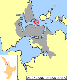 Location of Devonport in Auckland. | |
| Basic information | |
| Local authority | Auckland Council |
| Electoral ward | North Shore |
| Local board | Devonport-Takapuna |
| Date established | 1840s |
| Population | 5,337 (2006 census) |
| Postcode(s) | 0624 |
| Facilities | |
| Ferry terminal(s) | Devonport Wharf |
| Hospitals(s) | Navy Hospital |
| Surrounds | |
| North | Vauxhall |
| Northeast | Cheltenham |
| East | (North Head) |
| Southeast | (Waitemata Harbour) |
| South | (Waitemata Harbour) |
| Southwest | (Waitemata Harbour) |
| West | Stanley Bay |
| Northwest | (Duders Point) |
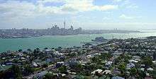
Devonport is a harbourside suburb of Auckland, New Zealand. It is located on the North Shore, at the southern end of a peninsula that runs southeast from near Lake Pupuke in Takapuna, forming the northern side of the Waitemata Harbour. East of Devonport lies North Head, the northern promontory guarding the mouth of the harbour.
The population of Devonport and the adjoining suburb of Cheltenham was 5,337 in the 2006 Census, an increase of 126 since 2001.[1] With the additional suburbs of Stanley Bay, Vauxhall and Narrow Neck, the 2006 population was 11,142.[2]
The suburb hosts the Devonport Naval Base of the Royal New Zealand Navy, the main facility for the country's naval vessels, but is best known for its harbourside dining and drinking establishments and its heritage charm. In its scenery and setting, Devonport has been compared to Sausalito, California.[3]
Character
The Devonport shops contain a fair array of antiques, gift & book shops as well a number of good cafes and restaurants making it a popular destination for tourists and Aucklanders. People often travel over from Auckland on the ferry for dinner, the starry sky and glittering lights of Auckland on the return trip being very beautiful.
Day trips combining a meal in Devonport with a trip up Mt Victoria or an exploration of the military emplacements on nearby North Head are also very popular. Devonport is also noted for the popular annual event, the Devonport Food & Wine Festival,[4] as well as for the Devonport Museum located near Mt. Cambria.
The navy base at Devonport features strongly in the local character, with the North Shore City Council having signed a Memorandum of Understanding with the Navy which recognises the developing partnership between them.[5] The Torpedo Bay Navy Museum is also located in Devonport.[6]
History
Overview
Around 40,000 years ago Devonport consisted of three islands of volcanic origin, Mount Victoria, North Head and between them Mount Cambria (now largely quarried away).[7]
The earliest evidence for (Māori) settlement dates from the mid-14th century (roughly during the same time as the supposed landing of the Tainui waka which is commemorated by a stone memorial on the foreshore).[8] The last remaining significant Māori settlement in the area, on North Head, was wiped out by rival tribes in the 1790s.[9]
Jules Dumont d'Urville, a French explorer, is thought to have gone ashore in the area in 1827, possibly as the first European.[8] The first permanent European inhabitant was a pilot and harbour master stationed on North Head in 1836.[9] The suburb of Devonport itself was first settled in 1840 and is one of the oldest in Auckland and the first on the North Shore. It was initially called Flagstaff because of the flagstaff raised on nearby Mount Victoria (Takarunga). For the first half century or so of its existence Devonport was geographically isolated from the rest of the North Shore, and was sometimes called "the island" by the local inhabitants.[10] Only a thin strip of land beside the beach at Narrow Neck connected Devonport to Belmont and the rest of the North Shore peninsula. In the late 19th century the mangrove swamp that stretched from Narrow Neck to Ngataringa Bay was filled in to form a racecourse, now a golf course.[10] A new road was built along the western edge of the racecourse allowing more direct travel to the north.
On the southern shore, to the west of the centre of Devonport, a nearby deep water anchorage suitable for Royal Navy vessels, the Devonport Naval Base was established. William Hobson, then the Governor of New Zealand, considered the sandspit-protected area a better choice for a naval installation than the shallower Tamaki waters on the southern side of the harbour.[8] While some facilities have expanded and shifted in location over time, the area is still the primary base for the Royal New Zealand Navy. The Calliope Dock at Stanley Bay, part of the base, was opened on 16 February 1888 and at the time was the largest dock in the Southern hemisphere. The suburb also had one of the oldest New Zealand shipyards, now part of the Devonport Yacht Club area.[8]
The main centre of the suburb slowly shifted west from Church Street and the original wharf at Torpedo Bay, to its current location around the ferry wharf.[8] The settlement itself was renamed Devonport by 1859 after the English naval town of Devonport.[11] Devonport achieved Borough status in 1886 and was incorporated into North Shore City in 1989.
Devonport played a special role in the nuclear free movement. In 1981 the Devonport Borough Council voted to declare Devonport a nuclear-free zone, the first local council in New Zealand to do so.[12]
In July 2007, Devonport was given permission to be excluded from a list of local Auckland growth node centres. The Auckland Regional Council accepted that while it was encouraging intensified growth (such as higher-density housing) around transport nodes such as Devonport, the character and historical nature of the Devonport Wharf area would make such a designation inappropriate in this case.[13]
In 2011 the Devonport community, led by parents and local publication the Devonport Flagstaff, launched a grassroots movement protesting the sale of the synthetic cannabis Kronic in local dairies. The battle was a success, and Kronic was banned from the area.[14]
Ferries
The first ferry services to Auckland city began in the 1840s. These were open sailing cutters operated by local seamen running passengers to the foot of Queen Street, Auckland's main road. In 1860 the first paddlesteamer ferries began operation.[7][10]
These were in turn replaced by double-ended, screw-driven ferries in 1904.[10] Both passenger and vehicle ferries operated on the Devonport run until the opening of the Auckland Harbour Bridge in 1959. Immediately after the opening of the bridge, passenger ferry services to other North Shore destinations (such as Northcote and Birkenhead) were cancelled, as were all vehicular ferries. The Devonport passenger ferry was retained on a much reduced timetable. The majority of the ferries were scrapped, only a handful being retained until being replaced by more modern vessels. The last of the old-style double-ended ferries, the diesel-engined Kestrel (built in 1905), was retired from the commuter run in 1988 and was then operated for cruises and sightseeing. In 2002 the Kestrel was moved to Tauranga to serve as a floating restaurant. The Kestrel changed hands again in 2010 and moved back to Auckland.[15] On 8 March 2016 the Kestrel broke up and sank while tethered in its Wynyard Quarter berth.[16]
Notable Cultural landmarks
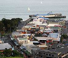
Devonport CBD
Between the wharf and Mt Victoria are the Devonport shops, here are located a number of interesting landmarks:
- The Esplanade Hotel; This is an elegant example of an 1890s seaside hotel, reminiscent of many an English seaside resort of the period. This had a modern extension added on in the 1950s which has now been replaced by an apartment complex. The Edwardian building has recently been renovated and restored.
- Windsor Reserve; located just to the east of the Devonport Wharf is this area of open lawn. It is notable for the 1980s toilet block and the Edwardian archway at the northern end.
- King Edward Parade Reserve; To the north of the Windsor Reserve on the other side of the road is the King Edward Parade Reserve; here are located the 1970s Public Library (currently 2014 being rebuilt), the War Memorial (a bronze soldier figure by Richard Gross ) and under the Moreton Bay Fig trees a charming 1950s styled bandstand.
- The Former Post Office. An Art Deco gem from the 1930s.
- The Left Bank. A 1920s neoclassical building now housing a cafe/bar/restaurant.
- The Victoria Cinema. Built in 1912 and remodelled in the 1930s internally and externally in the then fashionable Art Deco Style, this is apparently the oldest cinema in the Southern hemisphere in continuous use. Victoria Cinema has since opened after renovations, having been purchased in 2006 by the North Shore City Council on behalf of the city.[17]
Devonport Wharf
Today, ferry services to Devonport Wharf are more numerous again, and are subsidised by Auckland Transport, . A crossing between the Auckland CBD and Devonport takes about 12 minutes, usually on the 'Seabus Kea', a newer double-ended ferry.[10]
The Devonport Wharf / Ferry Terminal received a variety of maintenance and repairs during 2011 in advance of the Rugby World Cup. Further structural works are to be carried out in 2012.[18]
In 2015 a $24 million redevelopment project to upgrade parts of Devonport including the wharf began. The renovation of the Devonport wharf is all but complete, with applications for retail services currently underway. The project includes an improved car park and an overall modernization of the building itself, as well as structural improvements and refurbishments.[19]
| Broadcast area | Devonport, Auckland, New Zealand |
|---|---|
| Slogan | North Shore Community Radio |
| First air date | May 1999 |
| Owner | North Harbour Community Radio Trust |
| Website | theflea.co.nz |
The Flea FM
The Flea 88.2 FM &107.1FM is a community radio station in Auckland, New Zealand.[20] It broadcasts with a legally restricted 1000 milliwatts from Mount Victoria, Devonport & also from Takapuna. The station is widely heard because of superior aerial location, with a studio located in the Devonport Ferry Building. The station was created by Mike Baker, in May 1999. It was originally developed to serve Devonport and the neighbouring suburbs. In recent times a second transmitter was added in the Takapuna area and the station now covers the Takapuna and Milford suburbs as well. The station founder, Mike Baker, died on 4 April 2009, at the age of 71.[21]
Devonport Primary School
Devonport Primary School is a co-ed primary school located on the side of Mount Victoria with the address of 18 Kerr Street. The school was establish in 1870 on a plot of land given to them by the Trevarthen family for the purposes of a chapel, before it was later renegotiated to be used as a school.[22]
The decile 10 school plays host to students from year 0 to 6 and usually has 2 classes for each year group. As of 1 July 2016, the register is 307 students, including 167 male and 140 female.[23]
Sport
North Shore United AFC
North Shore United are an association football club that play their football at Allen Hill Stadium, located near the southern end of Lake Road. The club, founded in 1887, currently play in the NRFL Division 1, a league in the third tier of New Zealand Football. The club is the oldest in both New Zealand and Oceania, winning the Chatham Cup 6 times and the New Zealand Club Championship twice.
North Shore RFC
North Shore Rugby Football Club is a Rugby Union club located in Devonport that play their games at Devonport Domain. Founded in 1873, it is one of the oldest clubs in New Zealand.
Notable people
- Isabel Maude Peacocke - teacher, novelist, broadcaster, born in Devonport in 1881.[24]
- Sir Dove-Myer Robinson - former Auckland Mayor[25] born 1901, died 1989.
- A. R. D. Fairburn - poet, satirist, and critic. Born 1904
- Sir Peter Blake - international yachtsman, born 1948, died 2001.
- Tim Finn - musician and singer, current residence in Devonport, born 1952.
- Rikki Morris - musician and sound engineer, born 1960
- Debbie Harwood, musician and singer, notable as a member of When The Cat's Away.
- Tom Ashley - sailor, windsurfer. Gold Medal at 2008 Beijing Olympics in Mens' Sail Boarding. Born 1984.
- Gin Wigmore - singer-songwriter, born 1986.
- James Doyle - professional rugby player (Leicester Tigers Sale Sharks, Leeds Carnegie), born 1991.
- Lorde - pop artist born 1996. Attended Takapuna Grammar School.
- Eliza McCartney, NZ women's pole vault champion and women's pole vault World Junior Record holder. 2016 Olympics Pole Vault Bronze medal winner. Born 1996.
See also
- William C Daldy, a historical steam tug currently berthed in Devonport
References
- ↑ The statistical area used by the Census is called Mt Victoria. Quickstats about Mt Victoria
- ↑ "The North Shore". Te Ara Encyclopedia of New Zealand. Retrieved 2008-06-16.
- ↑ In Auckland, Life Is Alfresco – The New York Times, 5 October 1997
- ↑ Devonport Food & Wine Festival (official festival website)
- ↑ Navy and North Shore City Council Join Forces (from the Royal New Zealand Navy website. Accessed 2008-05-11.)
- ↑ "Visit us". Torpedo Bay Navy Museum. Retrieved 16 June 2012.
- 1 2 About Devonport 1 (from the devonpporttours.co.nz website)
- 1 2 3 4 5 Set sail for adventure on dry land – The New Zealand Herald, Travel: NZ Special Issue, Tuesday 6 November 2007, Page D7
- 1 2 About Devonport 2 (from the devonpporttours.co.nz website)
- 1 2 3 4 5 Destination History – Devonport (from the Fullers Ferries website. Retrieved 2007-09-14.)
- ↑ Wises New Zealand Guide, 7th Edition, 1979. Page 83
- ↑ "Shore now a Peace City". North Shore Times. 1 December 2009. Retrieved 30 March 2014.
- ↑ Development gets thumbs down – The New Zealand Herald, Tuesday 17 July 2007, Page A9
- ↑ http://tvnz.co.nz/national-news/grassroots-battle-against-kronic-proves-success-4271298
- ↑ "The Kestrel Plans A Return To Devonport". The Devonport Speculator. 24 August 2010. Retrieved 9 September 2011.
- ↑ "Historic Auckland ferry the Kestrel sinks". New Zealand Herald. 2016-03-08. ISSN 1170-0777. Retrieved 2016-03-07.
- ↑ "Victoria Theatre – FAQ's". Retrieved 2007-06-14.
- ↑ "Devonport Wharf's makeover completed". Media release from Auckland Transport. 9 September 2011. Retrieved 9 September 2011.
- ↑ Transport, Auckland. "Devonport Wharf redevelopment". at.govt.nz. Retrieved 2016-11-07.
- ↑ "Battle of the Auckland airwaves". New Zealand Herald. 12 December 2004. Retrieved 22 March 2009.
- ↑ "Dunedin radio identity dies", Otago Daily News, 6 April 2009, retrieved 4 August 2012
- ↑ "Archives". www.devonport.school.nz. Retrieved 2016-11-07.
- ↑ "Schools / Homepage - Te Kete Ipurangi (TKI)". www.tki.org.nz. Retrieved 2016-11-07.
- ↑ Peacocke, Isabel Maude (entry in the Dictionary of New Zealand Biography)
- ↑ Robinson, Dove-Myer (entry in the Dictionary of New Zealand Biography)
External links
| Wikimedia Commons has media related to Devonport, New Zealand. |
 Devonport (New Zealand) travel guide from Wikivoyage
- Devonport School
- Photographs of Devonport held in Auckland Libraries' heritage collections.
Coordinates: 36°49′54″S 174°47′47″E / 36.831667°S 174.796278°E