Devbhumi Dwarka district
This article is about the district. For its eponymous headquarters, see Khambhalia.
| Devbhumi Dwarka district દેવભૂમિ દ્વારકા જિલ્લો | |
|---|---|
| District of Gujarat | |
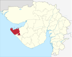 Location in Gujarat | |
| Coordinates: 22°12′N 69°39′E / 22.200°N 69.650°ECoordinates: 22°12′N 69°39′E / 22.200°N 69.650°E | |
| Country |
|
| State | Gujarat |
| District | Khambaliya |
| Area | |
| • Total | 4,051 km2 (1,564 sq mi) |
| Population (2011) | |
| • Total | 752,484 |
| • Density | 190/km2 (480/sq mi) |
| Languages | |
| • Official | Gujarati, Hindi |
| Time zone | IST (UTC+5:30) |
| Vehicle registration | GJ |
| Website | Official Website of Devbhumi Dwarka District |
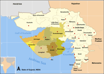
Districts of Saurastra, Gujarat
Devbhumi Dwarka District is a district of India located on the southern coast of the Gulf of Kutch in the state of Gujarat. Its headquarters are located in the city of Khambhalia. The district was created on August 15, 2013 from Jamnagar district.[1][2][3]
Talukas (Administrative Divisions)
- Dwarka
- Bhanvad
- Kalyanpur
- Khambhalia
Demographics
Devbhumi Dwarka district has a population of 7,52,484 area is 4,051 km2.[4]
References
- ↑ "Independence Day - new Dwarka district ~ Jamnagar News". jamnagar-news.blogspot.co.uk. Retrieved 25 April 2015.
- ↑ "Seven new districts as Gujarat's I-Day gift | Latest News & Updates at". Dnaindia.com. 2013-08-14. Retrieved 2014-03-04.
- ↑ "7 new districts to start functioning from Independence Day - The Times of India". Articles.timesofindia.indiatimes.com. 2013-08-14. Retrieved 2014-03-04.
- ↑ About Devbhumi Dwarka
External links
| Wikimedia Commons has media related to Devbhumi Dwarka district. |
 |
Gulf of Kutch | Gulf of Kutch | Gulf of Kutch | |
| Arabian Sea | |
Jamnagar district | ||
| ||||
| | ||||
| Arabian Sea | Porbandar district | Porbandar district |
| Topics |  | |
|---|---|---|
| Regions of Gujarat |
| |
| Districts | ||
| Major cities | ||
| Ecoregions | ||
| Economy |
| |
| ||
This article is issued from Wikipedia - version of the 10/28/2016. The text is available under the Creative Commons Attribution/Share Alike but additional terms may apply for the media files.