Daulatabad, Maharashtra
| Daulatabad दौलताबाद Devagiri | |
|---|---|
| Town | |
|
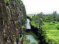
The Devagiri-Daulatabad fort with a tunnel entrance, cannon post, and narrow access bridge | |
 Daulatabad Location of Daulatabad (Devagiri) in Maharashtra | |
| Coordinates: 19°56′34″N 75°12′47″E / 19.942724°N 75.213164°ECoordinates: 19°56′34″N 75°12′47″E / 19.942724°N 75.213164°E | |
| Country | India |
| State | Maharashtra |
| Region | Marathwada |
| District | Aurangabad |
| Demonym(s) | Daulatabadi, Devagirikar |
| Language | |
| • Official | Marathi |
| Time zone | IST (UTC+5:30) |
| PIN | 431002 |
| Vehicle registration | MH-20 |
Daulatabad also known as Devagiri, is a town which includes the Devagiri-Daulatabad fort[1][2][3] It carries the distinction of remaining undefeated in battle. It is a 14th-century fort city in Maharashtra state of India, about 16 kilometres (9.9 mi) northwest of Aurangabad. The place was originally named Devagiri [4][5] when it was an important uplands city along caravan routes (ca. sixth century AD), but the intervening centuries have reduced it to a village. However it is also considered to be one of the seven wonders of Maharashtra and a developing tourist spot.[6][7][8][9]
The historical triangular fort of Daulatabad was built by first Yadav king Bhilan in 1187.[10]
Starting 1327, it famously remained the capital of Tughlaq dynasty, under Muhammad bin Tughluq (r. 1325-1351), who also changed its name, and forcibily moved the entire population of Delhi for two years before it was abandoned for lack of water and Tughluq was constantly known to shift the capital from Delhi to Daulatabad and Daulatabad to Delhi.[11]
There is a belief that Devagiri was built in 1203 AD by a Dhangar or herdsman who acquired vast wealth by his good fortune. He had a brother who was a shepherd named 'Raja Ram' and in correlation with it he assumed the rank of a Raja (King).[12]
Mythological origin
Lord Shiva is believed to have been stayed on the hills surrounding this region. Hence the fort was originally known as Devagiri literally (Hills of Gods).[13][14]
Fort of Daulatabad
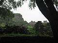
The area of the city includes the hill-fortress of Devagiri (Marathi) (sometimes Latinised to Deogiri). It stands on a conical hill, about 200 meters high. Much of the lower slopes of the hill has been cut away by Yadava dynasty rulers to leave 50 meter vertical sides to improve defenses. The fort is a place of extraordinary strength. The only means of access to the summit is by a narrow bridge, with passage for not more than two people abreast, and a long gallery, excavated in the rock, which has for the most part a very gradual upward slope.[15]
About midway along this gallery, the access gallery has steep stairs, the top of which is covered by a grating destined in time of war to form the hearth of a huge fire kept burning by the garrison above.[16] At the summit, and at intervals on the slope, are specimens of massive old cannon facing out over the surrounding countryside. Also at the mid way, there is a cave entrance meant to confuse the enemies.[17]
The City
Devagiri (190 57’ N; 750 15’ E) is located at a distance of 15 km northwest of Aurangabad, the district headquarters and midway to Ellora group of caves.[18] The original widespread capital city is now mostly unoccupied and has been reduced to a village. Much of its survival depends on the tourists to the old city and the adjacent fort.
.JPG)
.jpg)

History
The site had been occupied since at least 100 BCE, and now has remains of Buddhist temples similar to those at Ajanta and Ellora.
The city is said to have been founded c. 1187 by Bhillama V, a prince who renounced his allegiance to the Chalukyas and established the power of the Yadava dynasty in the west.[19]
Most of the fortification has been constructed under the Bahmanis and the Nizam Shahs of Ahmadnagar.[20] The Mughal Governor of the Deccan under Shah Jahan, captured the fortress in 1632 and imprisoned the Nizam Shahi prince Husain Shah.[21]
Monuments
The outer wall, 2.75 miles (4.43 km) in circumference, once enclosed the ancient city of Devagiri and between this and the base of the upper fort are three lines of defences.
Along with the fortifications, Devagiri contains several notable monuments, of which the chief are the Chand Minar and the Chini Mahal.[22] The Chand Minar is a tower 210 ft (64 m). high and 70 ft (21 m). in circumference at the base, and was originally covered with beautiful Persian glazed tiles. It was erected in 1445 by Ala-ud-din Bahmani to commemorate his capture of the fort. The Chini Mahal (literally: China Palace), is the ruin of a building once of great beauty. In it Abul Hasan Tana Shah, the last of the Qutb Shahi kings of Golconda, was imprisoned by Aurangzeb in 1687.[19]
Transport
Road Transport
Devagiri is in the outskirts of Aurangabad, and is on the Aurangabad - Ellora road (National Highway 2003). Aurangabad is well connected by road and 20 km away from Devagiri.[23]
Rail Transport
Daulatabad railway station is located on the Manmad-Purna section of Central Railways[24] and also on the Kachiguda-Manmad section of the Nanded Division of South Central Railway. Until reorganisation in 2012 ,it was a part of the Hyderabad Division Aurangabad is a major station near to Devagiri. The Devagiri Express regularly operates between Mumbai and Secunderabad via Aurangabad, Maharashtra
Gallery


.JPG) View from Pavilion
View from Pavilion.JPG) Canon pointing into distance from Pavilion
Canon pointing into distance from Pavilion.JPG) Pavilion, high up the fort
Pavilion, high up the fort.JPG) Track within Devgiri Fort
Track within Devgiri Fort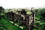 Devgiri Fort & Monument therein (i.e. Chand Minar)
See also
References
- ↑ "Devagiri-Daulatabad Fort". Maharashtra Tourism Development Corporation. Maharashtra, India. Retrieved May 2015. Check date values in:
|access-date=(help) - ↑ "मध्यकालीन भारत में सबसे ताकतवर था दौलताबाद किला" [Madhyakālīn Bhārat Mēṁ Sabsē Tākatavar Thā Daulatābād Kilā]. Aaj Tak (in Hindi). India. August 2012. Retrieved May 2015. Check date values in:
|access-date=(help) - ↑ "देवगिरी – दौलताबाद" [Dēvagirī - Daulatābād]. www.majhapaper.com (in Marathi). Maharashtra. September 2012. Retrieved May 2015. Check date values in:
|access-date=(help) - ↑ "Daulatabad Fort".
- ↑ Gopal, Madan (1990). K.S. Gautam, ed. India through the ages. Publication Division, Ministry of Information and Broadcasting, Government of India. p. 174.
- ↑ "ऑक्टोबरपासून हॉट बलून सफारी" [Octoberpāsūn Hot Balloon Safari]. Maharashtra Times (in Marathi). Khultabad. 25 May 2015. Retrieved 5 June 2015.
- ↑ Neha Madaan (March 2015). "Virtual walks through tourist spots may be a reality". The Times of India. Pune. Retrieved May 2015. Check date values in:
|access-date=(help) - ↑ "રાજ્યના 'સેવન વંડર્સ'માં અજંતા, સીએસટી, દૌલતાબાદ, લોનાર" [Rājyanā 'Seven Wonders'māṁ Ajantā, Sī'ēsaṭī, Daulatābād, Lōnār]. Divya Bhaskar (in Gujarati). India. November 2013. Retrieved May 2015. Check date values in:
|access-date=(help) - ↑ "स्वरध्यास फाउंडेशनच्या कलावंतांनी स्वच्छ केला दौलताबाद किल्ला" [Svaradhyās Foundationcyā Kalāvantānnī Svacch Kēlā Daulatābād Killā]. Divya Marathi. Aurangabad. 18 November 2014. Retrieved 5 June 2015.
- ↑ Bajwa, Jagir Singh; Kaur, Ravinder (2007). Tourism Management. APH Publishing. p. 249. ISBN 9788131300473. Retrieved 3 July 2016.
- ↑ Raj Goswami (May 2015). "UID યુનિક ઈન્ડિયન ડોન્કી!" [UID Unique Indian Delhi]. Mumbai Samachar (in Gujarati). India. Retrieved May 2015. Check date values in:
|access-date=(help) - ↑ The Asiatic journal and monthly register for British and foreign India, pg 355. Published in 1827.
- ↑ Vidya Shrinivas Dhoot (February 2012). "देवगिरी किल्ल्याच्या बुरुजावरून.." [Dēvagirī Killyācyā Burujāvarūn..]. Divya Marathi (in Marathi). Aurangabad, Maharashtra. Retrieved May 2015. Check date values in:
|access-date=(help) - ↑ Dayanand Pingale (February 2014). "अद्भुत देवगिरी" [Adbhut Dēvagirī]. Prahaar (in Marathi). Aurangabad, Maharashtra. Retrieved May 2015. Check date values in:
|access-date=(help) - ↑ Gopal, Madan (1990). K.S. Gautam, ed. India through the ages. Publication Division, Ministry of Information and Broadcasting, Government of India. p. 176.
- ↑
 One or more of the preceding sentences incorporates text from a publication now in the public domain: Chisholm, Hugh, ed. (1911). "Daulatabad". Encyclopædia Britannica. 7 (11th ed.). Cambridge University Press. pp. 848–849.
 - ↑ "दौलतीचे शहर दौलताबाद" [Daulatīcē śahar Daulatābād]. Maharashtra Times (in Marathi). Maharashtra. December 2007. Retrieved May 2015. Check date values in:
|access-date=(help) - ↑ "Ticketed Monuments - Maharashtra Daulatabad Fort". Archaeological Survey of India. Retrieved May 2015. Check date values in:
|access-date=(help) - 1 2 Qureshi, Dulari (2004). Fort of Daulatabad. New Delhi: Bharatiya Kala Prakashan. ISBN 81-8090-072-X. Retrieved March 7, 2010.
- ↑ Sohoni, Pushkar (2015). Aurangabad with Daulatabad, Khuldabad and Ahmadnagar. Mumbai ; London: Jaico Publishing House ; Deccan Heritage Foundation,. ISBN 9788184957020.
- ↑ Sen, Sailendra (2013). A Textbook of Medieval Indian History. Primus Books. p. 170. ISBN 978-9-38060-734-4.
- ↑ "अभेद्य थी दौलताबाद किले की सुरक्षा" [Abhēdya Thī Daulatābād Kilē Kī Surakṣā]. www.prabhasakshi.com (in Marathi). New Delhi. 22 May 2012. Retrieved 11 August 2015.
- ↑ "Devgiri-Daultabad Fort". www.aurangabadcity.com. Aurangabad, Maharashtra. Retrieved May 2015. Check date values in:
|access-date=(help) - ↑ Hārd Samā. "ઐતિહાસિક સ્થળો" [Aitihāsik Sthaḷō]. www.gujaratcentre.com (in Gujarati). India. Retrieved May 2015. Check date values in:
|access-date=(help)
External links
| Wikimedia Commons has media related to Daulatabad, Maharashtra. |
| History | 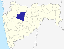 | |
|---|---|---|
| Geography | ||
| Monuments |
| |
| Culture | ||
| Education | ||
| Transport | ||
| Cities and towns | ||
| Neighbourhoods | ||
| Industrial Estates | ||
| Lok Sabha constituencies | ||
| Vidhan Sabha constituencies |
| |
| Judiciary | ||
| Sports | ||
| Other topics |
| |