Desire path
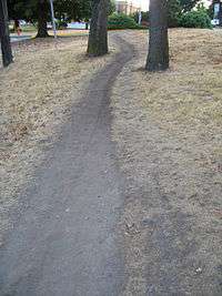
A desire path (formally referred to as desire line in transportation planning, also known as a game trail, social trail, herd path, cow path, goat track, pig trail or bootleg trail) can be a path created as a consequence of erosion caused by human or animal foot-fall or traffic. The path usually represents the shortest or most easily navigated route between an origin and destination. Width and erosion severity can be indicators of how much traffic a path receives. Desire paths emerge as shortcuts where constructed ways take a circuitous route, have gaps, or are non-existent.
Parks and nature areas

Desire paths sometimes cut through sensitive habitats and off-limit areas, threatening wildlife and park security. However, they also provide an indicator to park management of activity concentration. The National Park Service unit at the Yosemite National Park in the United States of America uses this indicator to help establish its General Management Plan.[1]
Trampling studies have consistently documented that impacts on soil and vegetation occur rapidly with initial use of desire paths. As few as 15 passages over a site can be enough to create a distinct trail, the existence of which then attracts further use.[2]:27 This finding contributed to the creation of the Leave No Trace education program, which, among other things, teaches that travelers in nature areas should either stay on designated trails or, when off trail, distribute their travel lines so as to not inadvertently create new trails in unsustainable locations.[3]
Land managers have devised a variety of techniques to block the creation of desire paths including fences, dense vegetation, or signage. However, hikers still penetrate these barriers. Because of this, state of the art trail design attempts to avoid the need for barriers and restrictions and instead seeks to bring trail layout and user desires in line with each other – both through physical design and through persuasive outreach to users.[2]:16
Accommodation
Landscapers sometimes accommodate desire paths by paving them and integrating them into the official path network rather than blocking them.[4][5]
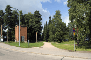
In some cases, land planners have deliberately left land fully or partially unpathed, waiting to see what desire paths are created, and then paving those.[4] In Finland, planners are known to visit their parks immediately after the first snowfall, when the existing paths are not visible.[6] People naturally choose desire paths, clearly marked by their footprints, which can be then used to guide the routing of new purpose-built paths.
In other cases, access to desired paths may be blocked in an attempt to enforce use of official paths. Remedies applied may include fencing off desired paths, erection of signs forbidding the use of desired paths and re-vegetating well worn paths.

Other uses of the concept
The image of a user-created path, in seeming defiance of authority, across the earth between the concrete, has captured the imagination of many as a metaphor for, variously, anarchism, intuitable design, individual creativity, or the wisdom of crowds.[7][8][9][10][11]
In urban planning, the concept of desire paths can be used when analyzing traffic patterns in any mode of travel. See, for example, its use in the 1959 Chicago Area Transportation Study to describe choices commuters made about railroad and subway trips.[12]
In software design, the term is used to describe the action of people widely adopting the same methods to overcome the limitations of the software they are using.[13] A representative example is Twitter, which has "paved" a number of desire paths by integrating them into the service, including @ mentions, hashtags, and group discussions.
See also
References
- ↑ Lubell, Mark. "ESP172 Lecture 9: National Parks" (PDF). University of California, Davis.
- 1 2 Hampton, Bruce; Cole, David (1988). Soft paths: how to enjoy the wilderness without harming it. Harrisburg, PA: Stackpole Books. ISBN 0-8117-2234-1.
- ↑ Marion, Jeffrey L.; Reid, Scott E. (January 2001). "Development of the U.S. Leave No Trace Program: An Historical Perspective" (PDF). Leave No Trace: Center for Outdoor Ethics.
- 1 2 Kurt Kohlstedt (January 30, 2016). "Least Resistance: How Desire Paths Can Lead to Better Design". 99% Invisible. Retrieved February 3, 2016.
- ↑ Bob Spieldenner (August 5, 2014). "Dirt paths on Drillfield to be paved". Virginia Tech News. Retrieved February 3, 2016.
- ↑ "Earls Court Project Application 1: The 21st Century High Street" (PDF). June 2011.
- ↑ Myhill, Carl (2004), "Commercial Success by Looking for Desire Lines", in Masodian, M; Jones, S; Rogers, B, 6th Asia Pacific Computer-Human Interaction Conference (APCHI 2004) (PDF), Rotorua, New Zealand: Springer-Verlag
- ↑ Lidwell, William; Holden, Katrina; Butler, Jill (2010). Universal principles of design: 125 ways to enhance usability, influence perception, increase appeal, make better design decisions, and teach through design. Rockport Publishers. ISBN 1-59253-587-9.
- ↑ Norman, Donald (2010). Living with Complexity. The MIT Press. ISBN 0-262-01486-6.
- ↑ Throgmorton, James; Eckstein, Barbara. "Desire Lines: The Chicago Area Transportation Study and the Paradox of Self in Post-War America". The 3Cities Project. Retrieved 26 May 2015.
- ↑ WGBH: A Cape Cod Notebook - Desire Lines by Robert Finch
- ↑ State of Illinois. (1959) "Chicago Area Transportation Study" p. 40. State of Illinois, Springfield, IL. Retrieved 14 March 2012 from Paul V. Galvin Library, Illinois Institute of Technology.
- ↑ Malone, Erin; Crumlish, Christian. "Pave the Cowpaths". Designing Social Interfaces. Retrieved 26 May 2015.
External links
| Wikimedia Commons has media related to Desire paths. |
- Wordspy: Desire Line
- https://www.flickr.com/groups/desire_paths/
- Desire Path subreddit
- Tom Hulme's TED Talk on using desire paths for better design and user experience