Derzhprom
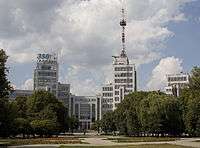


The Derzhprom or Gosprom (Ukrainian: Держпром; Russian: Госпром) building is a constructivist structure located in Freedom Square, Kharkiv, Ukraine. Its name is an abbreviation of two words that, taken together, mean State Industry. In English the structure is known as the State Industry Building or the Palace of Industry.
Overview
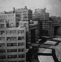
The building was one of a few showcase projects designed when Kharkiv was the capital of the Ukrainian SSR. Built by architects Sergei Serafimov, S.Kravets and M.Felger in only three years. It was to become the tallest structure in Europe for its time. The building also became the most spacious single structure in the world by the year of its completion in 1928 to be surpassed by New York's skyscrapers in 1930s. Its unique feature lies in the symmetry which can only be felt at one point, in the centre of the square.
The use of concrete in its construction and the system of overhead walkways and individual interlinked towers made it extremely innovative. It was rated by Reyner Banham as one of the major architectural achievements of the 1920s in his Theory and Design in the First Machine Age and comparable in scale only to the Dessau Bauhaus and the Van Nelle factory in Rotterdam.[1] This allowed the structure to fully survive any destruction attempts during the Second World War.
The Dezhprom complex was used as a symbol of modernity in films such as Dziga Vertov's Three Songs about Lenin and Sergei Eisenstein's The General Line. The building's notability was overshadowed following the 1936 move of the Ukrainian capital to Kiev, the later denunciation of Constructivism by Stalinist Architecture and the Second World War. More recently one of its towers was used as a television centre and a TV relay tower was built on its roof.
Interesting facts
- The height of the Derzhprom building is 63 m. With the television tower added in 1955 it was 108 m.
- The office area of the Derzhprom building is 60 000 m², the areas of the base is 10760 m².
- The decision to construct the building and to finance it from the Soviet budget was made by Felix Dzherzhynsky in 1926. The cost of the buildings construction was 9 million rubles.
- Initially the building was built by hand using primitive instruments such as shovels, wheelbarrows etc. By the time it was finished the construction techniques employed were mechanized 80%. 5000 workers were involved in its construction working in three shifts.
- At the time of its completion it was the largest "skyscraper" in the USSR and the second in Europe. 1315 carriages of cement, 9000 tonnes of metal, 2700 cars of granite and 40000 m² of glass were used.
- The interior walls, windows, door handles etc. were decorated with an exclusive relief of the letters DHP (ДГП) standing for Derzhprom.
- By the recommendation of the Kharkiv department of Hygiene, all of the door handles were made of copper which was thought at that time and is now known to have antibacterial characteristics to kill microbes.
- 7 of the 12 original elevators still function without being replaced since 1928.
- The length of the bridges that unite the 3 sections of the buildings is 26 metres.
- The 5th entrance has a museum created in 1980 dedicated to the building and to Kharkiv writer Z. Zvonytsky.
- The reconstruction and renovation of the Derzhprom building took more time (7 years) than the construction of the building itself. (3 years)
References
- ↑ (Architectural Press 1972, p. 297).
External links
- 1930s photographs by Robert Byron
- Article on the building (Russian)
- View during the war
- Photos by Luftwaffe pilots during World War II, some of the Derzhprom building
- Photo of the Derzhprom building
Coordinates: 50°0′23″N 36°13′38″E / 50.00639°N 36.22722°E